Property Record
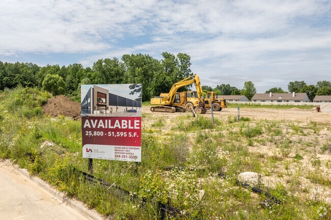
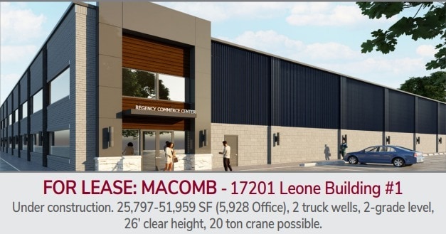
17201 Leone Dr, Macomb, MI 48042

Property Detail
17201 Leone Dr
20-08-17-344-027
REGENCY COMMERCE CENTER MCCP #653 UNIT 27
Industrialgeneral
MACOMB
M1
Michigan
B and X Area of moderate flood hazard, usually the area between the limits of the 100-year and 500-year floods.
5.11 AC
2025
Groesbeck North
2025
Detroit
223901
Detroit-Warren-Dearborn, MI
20,610 SF
NEARBY LISTINGS FOR SALE OR LEASE
DEMOGRAPHICS near 17201 Leone Dr
1 mile
3 mile
5 mile
2025 Total Population
6,233
78,001
174,773
2030 Population
6,254
78,643
176,703
Pop Growth 2025-2030
+ 0.34%
+ 0.82%
+ 1.10%
Average Age
47
41
42
2025 Total Households
2,470
26,403
66,196
HH Growth 2025-2030
+ 0.24%
+ 0.67%
+ 1.06%
Median Household Inc
$109,827
$121,060
$99,341
Avg Household Size
2.50
2.90
2.60
2025 Avg HH Vehicles
2.00
2.00
2.00
Median Home Value
$352,508
$385,363
$358,027
Median Year Built
1996
1997
1995
Nearby Places
Map Layers
Map Styles
 Street
 Aerial
Layers
 Traffic
 Biking
Places
Listings with unknown addresses are not visible on the map
- Restaurants
- Banks
- Shops
- Fitness
- Groceries
PUBLIC TRANSPORTATION
AIRPORT
Windsor International
Drive
Walk
Distance
Windsor International
70 min
42.6 mi
Nearby Properties
Address
Land Use
TOTAL SIZE
Lot Size
Zoning
Address
Land Use
TOTAL SIZE
Lot Size
Zoning
447,434 SF
23.29 AC
LM
Address
Land Use
TOTAL SIZE
Lot Size
Zoning
89,559 SF
44.54 AC
O2
Address
Land Use
TOTAL SIZE
Lot Size
Zoning
118,343 SF
7.33 AC
R1
Address
Land Use
TOTAL SIZE
Lot Size
Zoning
10.29 AC
LM
Address
Land Use
TOTAL SIZE
Lot Size
Zoning
90,185 SF
14.73 AC
C2
Address
Land Use
TOTAL SIZE
Lot Size
Zoning
79,942 SF
4.65 AC
M1
Address
Land Use
TOTAL SIZE
Lot Size
Zoning
120,658 SF
13.97 AC
C-3
Address
Land Use
TOTAL SIZE
Lot Size
Zoning
121,156 SF
9.40 AC
CK MAP
Address
Land Use
TOTAL SIZE
Lot Size
Zoning
293,800 SF
M1
Address
Land Use
TOTAL SIZE
Lot Size
Zoning
14.46 AC
R-7
Address
Land Use
TOTAL SIZE
Lot Size
Zoning
214,282 SF
22.26 AC
M1
Address
Land Use
TOTAL SIZE
Lot Size
Zoning
150,854 SF
8.50 AC
LM
Address
Land Use
TOTAL SIZE
Lot Size
Zoning
148,438 SF
4.82 AC
LM
Address
Land Use
TOTAL SIZE
Lot Size
Zoning
99,619 SF
8.24 AC
M1
Address
Land Use
TOTAL SIZE
Lot Size
Zoning
74,354 SF
10.62 AC
C3
Address
Land Use
TOTAL SIZE
Lot Size
Zoning
37.96 AC
AG
Address
Land Use
TOTAL SIZE
Lot Size
Zoning
312,087 SF
25.65 AC
M1
Address
Land Use
TOTAL SIZE
Lot Size
Zoning
56,766 SF
5.06 AC
C2
Address
Land Use
TOTAL SIZE
Lot Size
Zoning
99,188 SF
7.99 AC
LM
Address
Land Use
TOTAL SIZE
Lot Size
Zoning
4,064 SF
99.99 AC
R3
Address
Land Use
TOTAL SIZE
Lot Size
Zoning
104,455 SF
15.28 AC
LM
Address
Land Use
TOTAL SIZE
Lot Size
Zoning
74,858 SF
7.84 AC
CK MAP
Address
Land Use
TOTAL SIZE
Lot Size
Zoning
28,746 SF
10.70 AC
C3
Address
Land Use
TOTAL SIZE
Lot Size
Zoning
50,476 SF
7.53 AC
C-2
Address
Land Use
TOTAL SIZE
Lot Size
Zoning
85,339 SF
10.61 AC
C3
Address
Land Use
TOTAL SIZE
Lot Size
Zoning
101,647 SF
5.48 AC
LM
Address
Land Use
TOTAL SIZE
Lot Size
Zoning
99,634 SF
4.75 AC
LM
Address
Land Use
TOTAL SIZE
Lot Size
Zoning
130,899 SF
2.03 AC
M1
Address
Land Use
TOTAL SIZE
Lot Size
Zoning
64,308 SF
7.63 AC
C-2
Address
Land Use
TOTAL SIZE
Lot Size
Zoning
85,760 SF
4.44 AC
LM
The World's #1 Commercial Real Estate Marketplace
Connect with us
© 2026 CoStar Group
The information above has been obtained from sources believed reliable. While we do not doubt its accuracy we have not verified it and make no guarantee, warranty or representation about it. It is your responsibility to independently confirm its accuracy and completeness. Any projections, opinions, assumptions, or estimates used are for example only and do not represent the current or future performance of the property. The value of this transaction to you depends on tax and other factors which should be evaluated by your tax, financial, and legal advisors. You and your advisors should conduct a careful, independent investigation of the property to determine to your satisfaction the suitability of the property for your needs.