Property Record
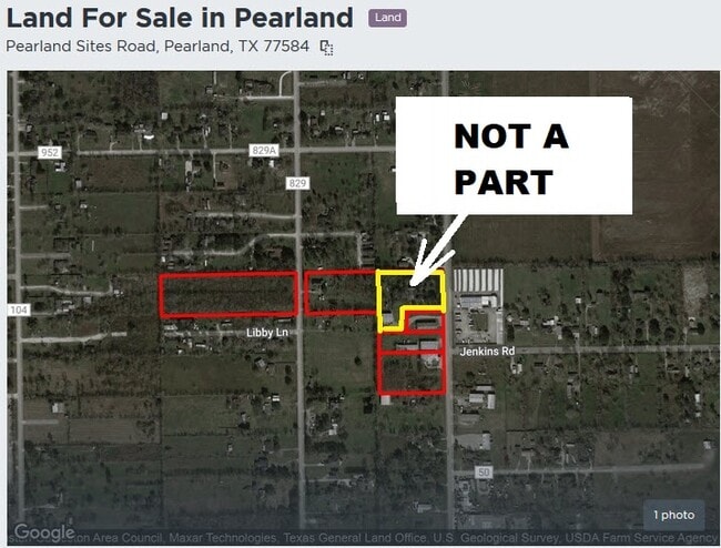
17202 Pearland Sites Rd, Pearland, TX 77584
NEARBY LISTINGS FOR SALE OR LEASE
Property Detail
17202 Pearland Sites Rd
Houston-The Woodlands-Sugar Land, TX
H T & B R R
0550-0070-000
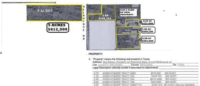
A0550 H T & B R R TRACT 25B2 (WELLBORN ACRES) ACRES 3.0
Commercialnec
Brazoria
X
Texas
48039C0043K
25b
2024
3 AC
2025
South
660902
Houston
6,062 SF
DEMOGRAPHICS near 17202 Pearland Sites Rd
1 Mile
3 Mile
5 Mile
2024 Total Population
4,480
39,395
115,278
2029 Population
4,938
43,486
126,027
Pop Growth 2024-2029
+ 10.22%
+ 10.38%
+ 9.32%
Average Age
36
37
37
2024 Total Households
1,401
13,218
38,486
HH Growth 2024-2029
+ 10.35%
+ 10.49%
+ 9.44%
Median Household Inc
$94,642
$93,419
$105,440
Avg Household Size
3.20
2.90
2.90
2024 Avg HH Vehicles
3.00
2.00
2.00
Median Home Value
$281,278
$279,269
$286,540
Median Year Built
1999
1997
1997
Nearby Places
Map Layers
Map Styles
 Street
 Aerial
- Restaurants
- Banks
- Shops
- Fitness
- Groceries
PUBLIC TRANSPORTATION
AIRPORT
William P Hobby
DRIVE
WALK
Distance
William P Hobby
21 min
9.8 mi
Freight Ports
Port of Houston
DRIVE
WALK
Distance
Port of Houston
32 min
18.0 mi
Nearby Properties
Address
Land Use
TOTAL SIZE
Lot Size
Zoning
Address
Land Use
TOTAL SIZE
Lot Size
Zoning
40.52 AC
0017
Address
Land Use
TOTAL SIZE
Lot Size
Zoning
83.37 AC
0004
Address
Land Use
TOTAL SIZE
Lot Size
Zoning
64.56 AC
0016
Address
Land Use
TOTAL SIZE
Lot Size
Zoning
236,642 SF
11.48 AC
Address
Land Use
TOTAL SIZE
Lot Size
Zoning
7.42 AC
Address
Land Use
TOTAL SIZE
Lot Size
Zoning
97,736 SF
16.49 AC
Address
Land Use
TOTAL SIZE
Lot Size
Zoning
252,472 SF
13.28 AC
Address
Land Use
TOTAL SIZE
Lot Size
Zoning
79.45 AC
1000
Address
Land Use
TOTAL SIZE
Lot Size
Zoning
144,879 SF
8.91 AC
Address
Land Use
TOTAL SIZE
Lot Size
Zoning
110,990 SF
18.25 AC
Address
Land Use
TOTAL SIZE
Lot Size
Zoning
89.23 AC
Address
Land Use
TOTAL SIZE
Lot Size
Zoning
155,524 SF
7.86 AC
Address
Land Use
TOTAL SIZE
Lot Size
Zoning
113,376 SF
9.80 AC
Address
Land Use
TOTAL SIZE
Lot Size
Zoning
148,902 SF
11.40 AC
Address
Land Use
TOTAL SIZE
Lot Size
Zoning
134,596 SF
7.21 AC
Address
Land Use
TOTAL SIZE
Lot Size
Zoning
67,595 SF
4.97 AC
Address
Land Use
TOTAL SIZE
Lot Size
Zoning
106,341 SF
12.12 AC
0550
Address
Land Use
TOTAL SIZE
Lot Size
Zoning
49.29 AC
0007
Address
Land Use
TOTAL SIZE
Lot Size
Zoning
80,715 SF
8.73 AC
Address
Land Use
TOTAL SIZE
Lot Size
Zoning
129,025 SF
7.02 AC
Address
Land Use
TOTAL SIZE
Lot Size
Zoning
63,615 SF
6.42 AC
0010
Address
Land Use
TOTAL SIZE
Lot Size
Zoning
86,550 SF
8.45 AC
Address
Land Use
TOTAL SIZE
Lot Size
Zoning
19.61 AC
Address
Land Use
TOTAL SIZE
Lot Size
Zoning
95,592 SF
5.93 AC
Address
Land Use
TOTAL SIZE
Lot Size
Zoning
151,863 SF
15.04 AC
Address
Land Use
TOTAL SIZE
Lot Size
Zoning
55,751 SF
5.04 AC
Address
Land Use
TOTAL SIZE
Lot Size
Zoning
45,108 SF
3.74 AC
Address
Land Use
TOTAL SIZE
Lot Size
Zoning
57,558 SF
3.96 AC
0061
Address
Land Use
TOTAL SIZE
Lot Size
Zoning
77,997 SF
19 AC
0065
Address
Land Use
TOTAL SIZE
Lot Size
Zoning
67,000 SF
28.97 AC
The World's #1 Commercial Real Estate Marketplace
Connect with us
© 2025 CoStar Group
The information above has been obtained from sources believed reliable. While we do not doubt its accuracy we have not verified it and make no guarantee, warranty or representation about it. It is your responsibility to independently confirm its accuracy and completeness. Any projections, opinions, assumptions, or estimates used are for example only and do not represent the current or future performance of the property. The value of this transaction to you depends on tax and other factors which should be evaluated by your tax, financial, and legal advisors. You and your advisors should conduct a careful, independent investigation of the property to determine to your satisfaction the suitability of the property for your needs.