Property Record
1721 James Madison Hwy, Haymarket, VA 20169
NEARBY LISTINGS FOR SALE OR LEASE
-
-
View all Haymarket listings for sale on LoopNet.com
Property Detail
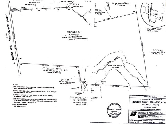
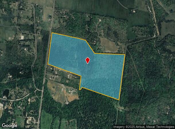
1721 James Madison Hwy
Washington-Arlington-Alexandria, DC-VA-MD-WV
School & Townsend Pc
7301-27-7569
JAMES MADISON HWY PT PAR 8 MP 166
Vacantlandnec
Prince William
A
Virginia
51107C0365E
7569
2024
118.95 AC
2025
Route 29/I-66 Corridor
901511
Washington, DC
DEMOGRAPHICS near 1721 James Madison Hwy
1 Mile
3 Mile
5 Mile
2024 Total Population
369
14,354
60,987
2029 Population
380
15,548
65,351
Pop Growth 2024-2029
+ 2.98%
+ 8.32%
+ 7.16%
Average Age
41
36
36
2024 Total Households
122
4,211
18,331
HH Growth 2024-2029
+ 3.28%
+ 8.07%
+ 7.05%
Median Household Inc
$188,043
$215,388
$183,770
Avg Household Size
3.00
3.40
3.30
2024 Avg HH Vehicles
3.00
2.00
2.00
Median Home Value
$600,806
$807,885
$753,555
Median Year Built
1980
2010
2010
Nearby Places
Map Layers
Map Styles
 Street
 Aerial
- Restaurants
- Banks
- Shops
- Fitness
- Groceries
PUBLIC TRANSPORTATION
AIRPORT
Washington Dulles International
DRIVE
WALK
Distance
Washington Dulles International
37 min
19.2 mi
Freight Ports
Port of Baltimore
DRIVE
WALK
Distance
Port of Baltimore
108 min
82.1 mi
SALE & LEASE HISTORY
LISTING DATE
SALE/LEASE

Jun 26, 2022
For Sale
Nearby Properties
Address
Land Use
TOTAL SIZE
Lot Size
Zoning
Address
Land Use
TOTAL SIZE
Lot Size
Zoning
536,602 SF
117.49 AC
TR3UBF
Address
Land Use
TOTAL SIZE
Lot Size
Zoning
192,413 SF
30.38 AC
TR3UBF
Address
Land Use
TOTAL SIZE
Lot Size
Zoning
39.24 AC
IP
Address
Land Use
TOTAL SIZE
Lot Size
Zoning
16,764 SF
17.76 AC
R1
Address
Land Use
TOTAL SIZE
Lot Size
Zoning
18,147 SF
6.91 AC
PDH3
Address
Land Use
TOTAL SIZE
Lot Size
Zoning
1,458 SF
34.43 AC
TR3UBF
Address
Land Use
TOTAL SIZE
Lot Size
Zoning
12,450 SF
168.09 AC
A1
Address
Land Use
TOTAL SIZE
Lot Size
Zoning
11,796 SF
2.47 AC
PDH3
Address
Land Use
TOTAL SIZE
Lot Size
Zoning
8,520 SF
10.03 AC
A3
Address
Land Use
TOTAL SIZE
Lot Size
Zoning
3,511 SF
2.32 AC
M1
Address
Land Use
TOTAL SIZE
Lot Size
Zoning
14.83 AC
AR2
Address
Land Use
TOTAL SIZE
Lot Size
Zoning
8,646 SF
11.96 AC
A1
Address
Land Use
TOTAL SIZE
Lot Size
Zoning
5,154 SF
191.12 AC
A1
Address
Land Use
TOTAL SIZE
Lot Size
Zoning
21.07 AC
A1
Address
Land Use
TOTAL SIZE
Lot Size
Zoning
7,168 SF
4.75 AC
TR1UBF
Address
Land Use
TOTAL SIZE
Lot Size
Zoning
6,942 SF
15.31 AC
A3
Address
Land Use
TOTAL SIZE
Lot Size
Zoning
6,290 SF
9.84 AC
A1
Address
Land Use
TOTAL SIZE
Lot Size
Zoning
7.46 AC
PDH3
Address
Land Use
TOTAL SIZE
Lot Size
Zoning
17,791 SF
3.03 AC
A1
Address
Land Use
TOTAL SIZE
Lot Size
Zoning
25.15 AC
AR2
Address
Land Use
TOTAL SIZE
Lot Size
Zoning
3,570 SF
41.99 AC
AR2
Address
Land Use
TOTAL SIZE
Lot Size
Zoning
360 SF
39.08 AC
A1
Address
Land Use
TOTAL SIZE
Lot Size
Zoning
27,850 SF
56.62 AC
A1
Address
Land Use
TOTAL SIZE
Lot Size
Zoning
7,662 SF
196.74 AC
A1
Address
Land Use
TOTAL SIZE
Lot Size
Zoning
30.35 AC
TR3UBF
Address
Land Use
TOTAL SIZE
Lot Size
Zoning
7,393 SF
232.26 AC
A1
Address
Land Use
TOTAL SIZE
Lot Size
Zoning
2,102 SF
62.78 AC
A1
Address
Land Use
TOTAL SIZE
Lot Size
Zoning
1,104 SF
64.51 AC
AR2
Address
Land Use
TOTAL SIZE
Lot Size
Zoning
6,678 SF
69.40 AC
A1
The World's #1 Commercial Real Estate Marketplace
Connect with us
© 2026 CoStar Group
The information above has been obtained from sources believed reliable. While we do not doubt its accuracy we have not verified it and make no guarantee, warranty or representation about it. It is your responsibility to independently confirm its accuracy and completeness. Any projections, opinions, assumptions, or estimates used are for example only and do not represent the current or future performance of the property. The value of this transaction to you depends on tax and other factors which should be evaluated by your tax, financial, and legal advisors. You and your advisors should conduct a careful, independent investigation of the property to determine to your satisfaction the suitability of the property for your needs.