Property Record
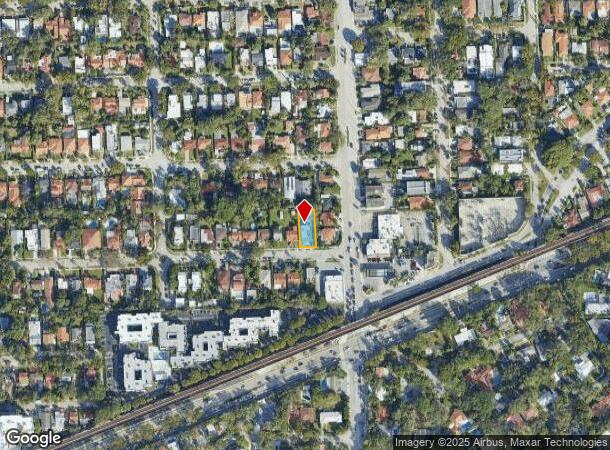
1721 Sw 24Th Ter, Miami, FL 33145

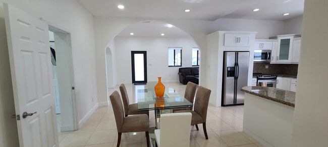
This Property Is For Sale
NEARBY LISTINGS FOR SALE OR LEASE
Property Detail
1721 Sw 24Th Ter
Miami-Miami Beach-Kendall, FL
Kensington Park
01-4115-044-0200
Miami/Dade
Duplex
Florida
X
0.17 AC
12086C0476L
Northeast Coconut Grove
1,951 SF
South Florida
DEMOGRAPHICS near 1721 Sw 24Th Ter
1 Mile
3 Mile
5 Mile
2024 Total Population
19,175
256,921
459,128
2029 Population
18,500
253,727
453,187
Pop Growth 2024-2029
(3.52%)
(1.24%)
(1.29%)
Average Age
45
42
41
2024 Total Households
7,725
113,894
193,454
HH Growth 2024-2029
(3.88%)
(1.34%)
(1.29%)
Median Household Inc
$76,987
$59,269
$58,243
Avg Household Size
2.40
2.20
2.20
2024 Avg HH Vehicles
2.00
1.00
1.00
Median Home Value
$658,199
$487,467
$481,312
Median Year Built
1955
1984
1979
Nearby Places
- Restaurants
- Banks
- Shops
- Fitness
- Groceries
PUBLIC TRANSPORTATION
TRANSIT/SUBWAY
Vizcaya (Metrorail Green Line - Miami-Dade Transit (Metrorail/Metromover))
DRIVE
WALK
Distance
Vizcaya (Metrorail Green Line - Miami-Dade Transit (Metrorail/Metromover))
3 min
15 min
0.8 mi
COMMUTER RAIL
Vizcaya (Metrorail Green Line - Miami-Dade Transit (Metrorail/Metromover))
DRIVE
WALK
Distance
Vizcaya (Metrorail Green Line - Miami-Dade Transit (Metrorail/Metromover))
3 min
14 min
0.7 mi
Coconut Grove (Metrorail Green Line - Miami-Dade Transit (Metrorail/Metromover))
DRIVE
WALK
Distance
Coconut Grove (Metrorail Green Line - Miami-Dade Transit (Metrorail/Metromover))
2 min
1.2 mi
AIRPORT
Miami International
DRIVE
WALK
Distance
Miami International
23 min
11.6 mi
Fort Lauderdale/Hollywood International
DRIVE
WALK
Distance
Fort Lauderdale/Hollywood International
37 min
25.9 mi
Freight Ports
Port of Miami
DRIVE
WALK
Distance
Port of Miami
12 min
5.5 mi
Nearby Properties
Address
Land Use
TOTAL SIZE
Lot Size
Zoning
Address
Land Use
TOTAL SIZE
Lot Size
Zoning
1,050,691 SF
0.83 AC
6408
Address
Land Use
TOTAL SIZE
Lot Size
Zoning
2,559,318 SF
2.21 AC
6407
Address
Land Use
TOTAL SIZE
Lot Size
Zoning
2,039,308 SF
2.46 AC
6401
Address
Land Use
TOTAL SIZE
Lot Size
Zoning
928,000 SF
14.30 AC
8000
Address
Land Use
TOTAL SIZE
Lot Size
Zoning
1,110,657 SF
3.83 AC
6407
Address
Land Use
TOTAL SIZE
Lot Size
Zoning
1,346,294 SF
1.89 AC
6408
Address
Land Use
TOTAL SIZE
Lot Size
Zoning
2,403,353 SF
7.37 AC
6100
Address
Land Use
TOTAL SIZE
Lot Size
Zoning
1,162,113 SF
1.92 AC
6407
Address
Land Use
TOTAL SIZE
Lot Size
Zoning
1,544,491 SF
0.97 AC
6401
Address
Land Use
TOTAL SIZE
Lot Size
Zoning
782,686 SF
0.06 AC
6401
Address
Land Use
TOTAL SIZE
Lot Size
Zoning
1,657,362 SF
1.15 AC
6401
Address
Land Use
TOTAL SIZE
Lot Size
Zoning
1,072,012 SF
1.78 AC
6407
Address
Land Use
TOTAL SIZE
Lot Size
Zoning
694,863 SF
1.90 AC
6407
Address
Land Use
TOTAL SIZE
Lot Size
Zoning
656,821 SF
2.06 AC
6407
Address
Land Use
TOTAL SIZE
Lot Size
Zoning
416,675 SF
6.48 AC
6401
Address
Land Use
TOTAL SIZE
Lot Size
Zoning
1,004,006 SF
0.92 AC
6401
Address
Land Use
TOTAL SIZE
Lot Size
Zoning
870,720 SF
1.90 AC
4800
Address
Land Use
TOTAL SIZE
Lot Size
Zoning
2.50 AC
6407
Address
Land Use
TOTAL SIZE
Lot Size
Zoning
491,308 SF
0.14 AC
6401
Address
Land Use
TOTAL SIZE
Lot Size
Zoning
872,245 SF
0.56 AC
6401
Address
Land Use
TOTAL SIZE
Lot Size
Zoning
727,757 SF
0.64 AC
6408
Address
Land Use
TOTAL SIZE
Lot Size
Zoning
2 AC
8000
Address
Land Use
TOTAL SIZE
Lot Size
Zoning
1,101,032 SF
5.18 AC
8000
Address
Land Use
TOTAL SIZE
Lot Size
Zoning
616,963 SF
0.75 AC
6401
Address
Land Use
TOTAL SIZE
Lot Size
Zoning
845,870 SF
1.30 AC
6412
Address
Land Use
TOTAL SIZE
Lot Size
Zoning
656,110 SF
1.75 AC
6401
Address
Land Use
TOTAL SIZE
Lot Size
Zoning
655,148 SF
0.30 AC
6401
Address
Land Use
TOTAL SIZE
Lot Size
Zoning
615,867 SF
1.87 AC
6402
Address
Land Use
TOTAL SIZE
Lot Size
Zoning
662,099 SF
3.54 AC
6405
Address
Land Use
TOTAL SIZE
Lot Size
Zoning
413,538 SF
3.07 AC
6408
The World's #1 Commercial Real Estate Marketplace
Connect with us
© 2025 CoStar Group
The information above has been obtained from sources believed reliable. While we do not doubt its accuracy we have not verified it and make no guarantee, warranty or representation about it. It is your responsibility to independently confirm its accuracy and completeness. Any projections, opinions, assumptions, or estimates used are for example only and do not represent the current or future performance of the property. The value of this transaction to you depends on tax and other factors which should be evaluated by your tax, financial, and legal advisors. You and your advisors should conduct a careful, independent investigation of the property to determine to your satisfaction the suitability of the property for your needs.