Property Record
17220 Highway 105 E, Conroe, TX 77306


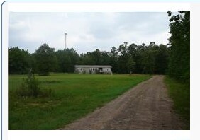
Property Detail
17220 Highway 105 E
8220-01-02000
POWELL 01 BLK 1 LOT 20 (AKA POWELL 02)
Commercialnec
Montgomery
1
Texas
B and X Area of moderate flood hazard, usually the area between the limits of the 100-year and 500-year floods.
20
2024
3 AC
2025
The Woodlands/Conroe
693001
Houston
7,563 SF
Houston-Pasadena-The Woodlands, TX
NEARBY LISTINGS FOR SALE OR LEASE
-
-
View all Conroe listings for sale on LoopNet.com
DEMOGRAPHICS near 17220 Highway 105 E
1 mile
3 mile
5 mile
2025 Total Population
5,150
17,732
31,069
2030 Population
6,141
21,219
37,079
Pop Growth 2025-2030
+ 19.24%
+ 19.67%
+ 19.34%
Average Age
33
35
36
2025 Total Households
1,514
5,416
9,869
HH Growth 2025-2030
+ 19.75%
+ 20.24%
+ 19.87%
Median Household Inc
$48,085
$59,192
$66,052
Avg Household Size
3.30
3.20
3.10
2025 Avg HH Vehicles
2.00
2.00
2.00
Median Home Value
$147,052
$191,094
$220,771
Median Year Built
2003
2005
2004
Nearby Places
Map Layers
Map Styles
 Street
 Aerial
Transit
 Traffic
 Biking
Places
Listings with unknown addresses are not visible on the map
- Restaurants
- Banks
- Shops
- Fitness
- Groceries
PUBLIC TRANSPORTATION
AIRPORT
George Bush Intcntl/Houston
Drive
Walk
Distance
George Bush Intcntl/Houston
52 min
40.5 mi
Freight Ports
Port of Houston
Drive
Walk
Distance
Port of Houston
75 min
56.2 mi
Nearby Properties
Address
Land Use
TOTAL SIZE
Lot Size
Zoning
Address
Land Use
TOTAL SIZE
Lot Size
Zoning
266,751 SF
12.95 AC
1
Address
Land Use
TOTAL SIZE
Lot Size
Zoning
124,209 SF
9.18 AC
1
Address
Land Use
TOTAL SIZE
Lot Size
Zoning
140,900 SF
83.24 AC
1
Address
Land Use
TOTAL SIZE
Lot Size
Zoning
84,192 SF
23.22 AC
1
Address
Land Use
TOTAL SIZE
Lot Size
Zoning
65,448 SF
10 AC
1
Address
Land Use
TOTAL SIZE
Lot Size
Zoning
9,120 SF
2.34 AC
Address
Land Use
TOTAL SIZE
Lot Size
Zoning
11,929 SF
35.97 AC
1
Address
Land Use
TOTAL SIZE
Lot Size
Zoning
50,652 SF
15 AC
1
Address
Land Use
TOTAL SIZE
Lot Size
Zoning
10,200 SF
1.06 AC
Address
Land Use
TOTAL SIZE
Lot Size
Zoning
28,920 SF
8.44 AC
1
Address
Land Use
TOTAL SIZE
Lot Size
Zoning
9,000 SF
1.10 AC
Address
Land Use
TOTAL SIZE
Lot Size
Zoning
43,371 SF
5.04 AC
Address
Land Use
TOTAL SIZE
Lot Size
Zoning
9,000 SF
1.15 AC
Address
Land Use
TOTAL SIZE
Lot Size
Zoning
13,960 SF
5 AC
Address
Land Use
TOTAL SIZE
Lot Size
Zoning
7,740 SF
1.07 AC
Address
Land Use
TOTAL SIZE
Lot Size
Zoning
8,356 SF
1.75 AC
Address
Land Use
TOTAL SIZE
Lot Size
Zoning
19,400 SF
5 AC
Address
Land Use
TOTAL SIZE
Lot Size
Zoning
5,000 SF
2 AC
1
Address
Land Use
TOTAL SIZE
Lot Size
Zoning
20,060 SF
7.20 AC
1
Address
Land Use
TOTAL SIZE
Lot Size
Zoning
7,725 SF
5.90 AC
1
Address
Land Use
TOTAL SIZE
Lot Size
Zoning
8,252 SF
40.31 AC
1
Address
Land Use
TOTAL SIZE
Lot Size
Zoning
33,170 SF
1.72 AC
1
Address
Land Use
TOTAL SIZE
Lot Size
Zoning
12,090 SF
1.04 AC
Address
Land Use
TOTAL SIZE
Lot Size
Zoning
15,900 SF
0.95 AC
1
Address
Land Use
TOTAL SIZE
Lot Size
Zoning
21,090 SF
3 AC
1
Address
Land Use
TOTAL SIZE
Lot Size
Zoning
10,380 SF
1.08 AC
1
Address
Land Use
TOTAL SIZE
Lot Size
Zoning
16,706 SF
3.56 AC
1
Address
Land Use
TOTAL SIZE
Lot Size
Zoning
6,600 SF
15.53 AC
1
The World's #1 Commercial Real Estate Marketplace
Connect with us
© 2026 CoStar Group
The information above has been obtained from sources believed reliable. While we do not doubt its accuracy we have not verified it and make no guarantee, warranty or representation about it. It is your responsibility to independently confirm its accuracy and completeness. Any projections, opinions, assumptions, or estimates used are for example only and do not represent the current or future performance of the property. The value of this transaction to you depends on tax and other factors which should be evaluated by your tax, financial, and legal advisors. You and your advisors should conduct a careful, independent investigation of the property to determine to your satisfaction the suitability of the property for your needs.