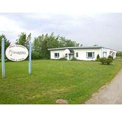
Property Record
1723 Hammond St, Hermon, ME 04401
NEARBY LISTINGS FOR SALE OR LEASE
-
-
View all Hermon listings for lease on LoopNet.com
Property Detail
1723 Hammond St
Commercialbuilding
Penobscot
X
Maine
23019C2111D
1.03 AC
2024
Maine North & Bangor
2024
Other Market Areas
010000
Bangor, ME
4,800 SF
HERM-000023-000001
DEMOGRAPHICS near 1723 Hammond St
1 mile
3 mile
5 mile
2024 Total Population
247
8,421
49,590
2029 Population
249
8,649
50,869
Pop Growth 2024-2029
+ 0.81%
+ 2.71%
+ 2.58%
Average Age
41
43
42
2024 Total Households
107
3,659
22,148
HH Growth 2024-2029
+ 1.87%
+ 2.84%
+ 2.71%
Median Household Inc
$63,333
$66,511
$57,206
Avg Household Size
2.30
2.20
2.10
2024 Avg HH Vehicles
2.00
2.00
2.00
Median Home Value
$231,250
$206,679
$217,471
Median Year Built
1989
1976
1967
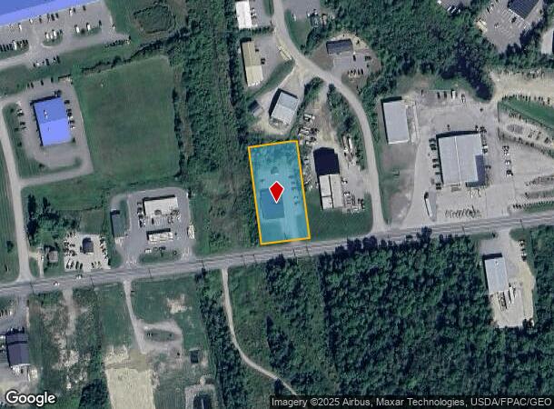
Nearby Places
Map Layers
Map Styles
 Street
 Aerial
Transit
 Traffic
 Biking
Places
Listings with unknown addresses are not visible on the map
- Restaurants
- Banks
- Shops
- Fitness
- Groceries
PUBLIC TRANSPORTATION
AIRPORT
Bangor International
Drive
Walk
Distance
Bangor International
6 min
1.7 mi
Freight Ports
Searsport, ME
Drive
Walk
Distance
Searsport, ME
49 min
33.4 mi
SALE & LEASE HISTORY
LISTING DATE
SALE/LEASE

Oct 12, 2016
For Sale
Dec 16, 2017
For Lease
Nearby Properties
Address
Land Use
TOTAL SIZE
Lot Size
Zoning
Address
Land Use
TOTAL SIZE
Lot Size
Zoning
466.65 AC
ADD
Address
Land Use
TOTAL SIZE
Lot Size
Zoning
87,750 SF
ADD
Address
Land Use
TOTAL SIZE
Lot Size
Zoning
38 AC
G&ISD
Address
Land Use
TOTAL SIZE
Lot Size
Zoning
Address
Land Use
TOTAL SIZE
Lot Size
Zoning
200,000 SF
40 AC
VILLAG
Address
Land Use
TOTAL SIZE
Lot Size
Zoning
119,930 SF
9.50 AC
S&PS
Address
Land Use
TOTAL SIZE
Lot Size
Zoning
144,000 SF
111.04 AC
32 - I
Address
Land Use
TOTAL SIZE
Lot Size
Zoning
111,000 SF
18.87 AC
HDR
Address
Land Use
TOTAL SIZE
Lot Size
Zoning
246,766 SF
22.44 AC
S&PS
Address
Land Use
TOTAL SIZE
Lot Size
Zoning
13.58 AC
Address
Land Use
TOTAL SIZE
Lot Size
Zoning
72,720 SF
14.11 AC
HDR
Address
Land Use
TOTAL SIZE
Lot Size
Zoning
56,910 SF
15 AC
G&ISD
Address
Land Use
TOTAL SIZE
Lot Size
Zoning
33,608 SF
18.10 AC
G&ISD
Address
Land Use
TOTAL SIZE
Lot Size
Zoning
66,333 SF
5.31 AC
GC&S
Address
Land Use
TOTAL SIZE
Lot Size
Zoning
76,143 SF
1.20 AC
ADD
Address
Land Use
TOTAL SIZE
Lot Size
Zoning
18,286 SF
12.48 AC
I&S
Address
Land Use
TOTAL SIZE
Lot Size
Zoning
21,030 SF
2.50 AC
S&PS
Address
Land Use
TOTAL SIZE
Lot Size
Zoning
186,836 SF
24.53 AC
UID
Address
Land Use
TOTAL SIZE
Lot Size
Zoning
466.65 AC
ADD
Address
Land Use
TOTAL SIZE
Lot Size
Zoning
134,304 SF
11.12 AC
INDUST
Address
Land Use
TOTAL SIZE
Lot Size
Zoning
4.23 AC
31 - I
Address
Land Use
TOTAL SIZE
Lot Size
Zoning
69,562 SF
8 AC
G&ISD
Address
Land Use
TOTAL SIZE
Lot Size
Zoning
38,280 SF
13 AC
31 - I
Address
Land Use
TOTAL SIZE
Lot Size
Zoning
57,020 SF
3.50 AC
HDR
Address
Land Use
TOTAL SIZE
Lot Size
Zoning
162,787 SF
7.09 AC
I&S
Address
Land Use
TOTAL SIZE
Lot Size
Zoning
45,904 SF
5.86 AC
T&SD
Address
Land Use
TOTAL SIZE
Lot Size
Zoning
46,318 SF
6.82 AC
GC&S
Address
Land Use
TOTAL SIZE
Lot Size
Zoning
111,548 SF
7.10 AC
I&S
Address
Land Use
TOTAL SIZE
Lot Size
Zoning
5.34 AC
INDUST
Address
Land Use
TOTAL SIZE
Lot Size
Zoning
64,704 SF
3.27 AC
GC&S
The World's #1 Commercial Real Estate Marketplace
Connect with us
© 2026 CoStar Group
The information above has been obtained from sources believed reliable. While we do not doubt its accuracy we have not verified it and make no guarantee, warranty or representation about it. It is your responsibility to independently confirm its accuracy and completeness. Any projections, opinions, assumptions, or estimates used are for example only and do not represent the current or future performance of the property. The value of this transaction to you depends on tax and other factors which should be evaluated by your tax, financial, and legal advisors. You and your advisors should conduct a careful, independent investigation of the property to determine to your satisfaction the suitability of the property for your needs.