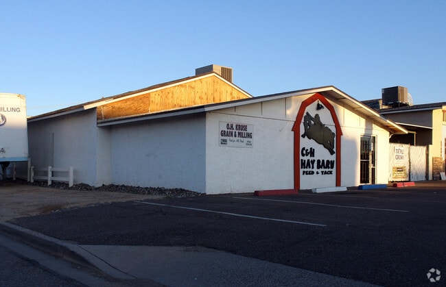
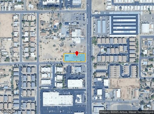
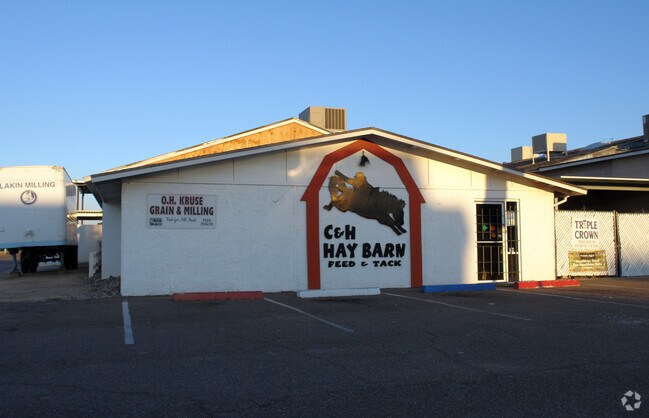
Property Record
17238 N Cave Creek Rd, Phoenix, AZ 85032
NEARBY LISTINGS FOR SALE OR LEASE
Property Detail
17238 N Cave Creek Rd
214-08-019C
S 130.725F OF NE4 NE4 SE4 SE4 EX S 25F & E 55F RD
Warehouse
Maricopa
X
Arizona
04013C1295M
0.67 AC
2025
East Phoenix
2025
Phoenix
619400
Phoenix-Mesa-Scottsdale, AZ
6,556 SF
DEMOGRAPHICS near 17238 N Cave Creek Rd
1 Mile
3 Mile
5 Mile
2024 Total Population
24,291
137,451
294,081
2029 Population
26,137
147,965
317,914
Pop Growth 2024-2029
+ 7.60%
+ 7.65%
+ 8.10%
Average Age
37
39
40
2024 Total Households
9,310
56,407
121,189
HH Growth 2024-2029
+ 7.67%
+ 7.74%
+ 8.25%
Median Household Inc
$59,019
$72,380
$77,190
Avg Household Size
2.50
2.40
2.40
2024 Avg HH Vehicles
2.00
2.00
2.00
Median Home Value
$278,664
$365,640
$403,822
Median Year Built
1988
1987
1986
Nearby Places
- Restaurants
- Banks
- Shops
- Fitness
- Groceries
PUBLIC TRANSPORTATION
AIRPORT
Phoenix Sky Harbor International
DRIVE
WALK
Distance
Phoenix Sky Harbor International
28 min
18.7 mi
Freight Ports
Port of San Diego
DRIVE
WALK
Distance
Port of San Diego
415 min
371.9 mi
Nearby Properties
Address
Land Use
TOTAL SIZE
Lot Size
Zoning
Address
Land Use
TOTAL SIZE
Lot Size
Zoning
281,880 SF
14.13 AC
Address
Land Use
TOTAL SIZE
Lot Size
Zoning
128,046 SF
9.97 AC
C2
Address
Land Use
TOTAL SIZE
Lot Size
Zoning
429,168 SF
9.52 AC
R-8
Address
Land Use
TOTAL SIZE
Lot Size
Zoning
342,574 SF
85.69 AC
R-18
Address
Land Use
TOTAL SIZE
Lot Size
Zoning
1,089,213 SF
53.03 AC
R-3
Address
Land Use
TOTAL SIZE
Lot Size
Zoning
336,494 SF
55.06 AC
R-43AG
Address
Land Use
TOTAL SIZE
Lot Size
Zoning
359,170 SF
37.47 AC
R-14
Address
Land Use
TOTAL SIZE
Lot Size
Zoning
482,581 SF
20.45 AC
C-C
Address
Land Use
TOTAL SIZE
Lot Size
Zoning
3.27 AC
C-C
Address
Land Use
TOTAL SIZE
Lot Size
Zoning
338,640 SF
10.39 AC
R-4A
Address
Land Use
TOTAL SIZE
Lot Size
Zoning
336,529 SF
11.23 AC
R4A
Address
Land Use
TOTAL SIZE
Lot Size
Zoning
211,239 SF
12.33 AC
M-M
Address
Land Use
TOTAL SIZE
Lot Size
Zoning
105,406 SF
22.69 AC
R-18
Address
Land Use
TOTAL SIZE
Lot Size
Zoning
355,606 SF
11.35 AC
C-C
Address
Land Use
TOTAL SIZE
Lot Size
Zoning
28,805 SF
2.67 AC
C-C
Address
Land Use
TOTAL SIZE
Lot Size
Zoning
255,482 SF
15.30 AC
M-H
Address
Land Use
TOTAL SIZE
Lot Size
Zoning
63,192 SF
94.91 AC
RE43
Address
Land Use
TOTAL SIZE
Lot Size
Zoning
316,766 SF
13.32 AC
M-H
Address
Land Use
TOTAL SIZE
Lot Size
Zoning
358,670 SF
18.14 AC
M-H
Address
Land Use
TOTAL SIZE
Lot Size
Zoning
127,252 SF
0.89 AC
C-C
Address
Land Use
TOTAL SIZE
Lot Size
Zoning
135,939 SF
19.35 AC
R1-8
Address
Land Use
TOTAL SIZE
Lot Size
Zoning
205,996 SF
20.50 AC
PAD-MD
Address
Land Use
TOTAL SIZE
Lot Size
Zoning
113,611 SF
1.43 AC
C-C
Address
Land Use
TOTAL SIZE
Lot Size
Zoning
120,494 SF
11.17 AC
C-C
Address
Land Use
TOTAL SIZE
Lot Size
Zoning
115,983 SF
4.85 AC
R-14
Address
Land Use
TOTAL SIZE
Lot Size
Zoning
286,650 SF
13.89 AC
M-L
Address
Land Use
TOTAL SIZE
Lot Size
Zoning
631 SF
83.59 AC
R-43AG
Address
Land Use
TOTAL SIZE
Lot Size
Zoning
247.81 AC
RE-43
Address
Land Use
TOTAL SIZE
Lot Size
Zoning
149,760 SF
16.13 AC
C-C
Address
Land Use
TOTAL SIZE
Lot Size
Zoning
362,106 SF
15.60 AC
M-H
The World's #1 Commercial Real Estate Marketplace
Connect with us
© 2025 CoStar Group
The information above has been obtained from sources believed reliable. While we do not doubt its accuracy we have not verified it and make no guarantee, warranty or representation about it. It is your responsibility to independently confirm its accuracy and completeness. Any projections, opinions, assumptions, or estimates used are for example only and do not represent the current or future performance of the property. The value of this transaction to you depends on tax and other factors which should be evaluated by your tax, financial, and legal advisors. You and your advisors should conduct a careful, independent investigation of the property to determine to your satisfaction the suitability of the property for your needs.