Property Record
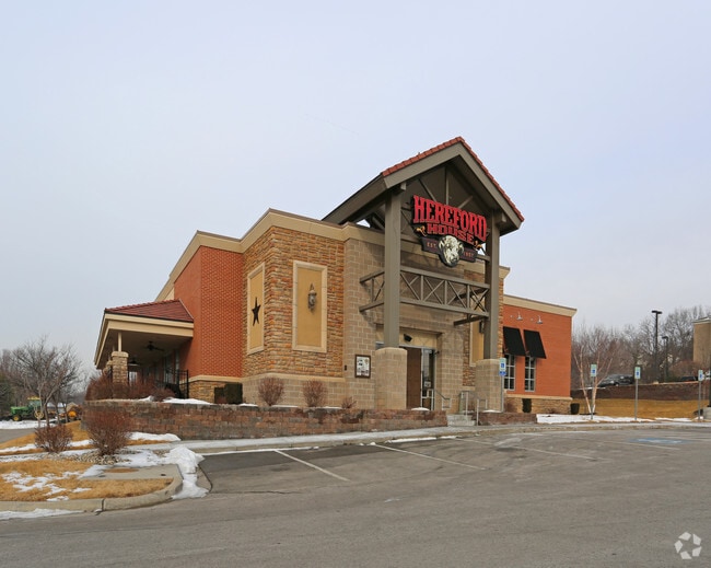
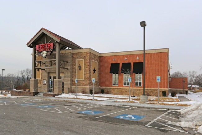
17244 Midland Dr, Shawnee, KS 66217

Property Detail
17244 Midland Dr
QP44250000-0002
MILL CREEK PLAZA SECOND PLAT LT 2 SHC 616 2 2
Restaurantbuilding
Johnson
PUDOC
Kansas
B and X Area of moderate flood hazard, usually the area between the limits of the 100-year and 500-year floods.
2
2024
1.83 AC
2025
Northwest Johnson County
052502
Kansas City
7,928 SF
Kansas City, MO-KS
NEARBY LISTINGS FOR SALE OR LEASE
DEMOGRAPHICS near 17244 Midland Dr
1 mile
3 mile
5 mile
2025 Total Population
2,122
45,220
137,495
2030 Population
2,176
46,531
141,854
Pop Growth 2025-2030
+ 2.54%
+ 2.90%
+ 3.17%
Average Age
44
41
40
2025 Total Households
976
18,386
55,387
HH Growth 2025-2030
+ 2.56%
+ 3.04%
+ 3.30%
Median Household Inc
$86,513
$110,884
$96,582
Avg Household Size
2.10
2.40
2.40
2025 Avg HH Vehicles
2.00
2.00
2.00
Median Home Value
$425,961
$395,043
$360,896
Median Year Built
1990
1991
1987
Nearby Places
Map Layers
Map Styles
 Street
 Aerial
Layers
 Traffic
 Biking
Places
Listings with unknown addresses are not visible on the map
- Restaurants
- Banks
- Shops
- Fitness
- Groceries
PUBLIC TRANSPORTATION
AIRPORT
Kansas City International
Drive
Walk
Distance
Kansas City International
38 min
31.5 mi
Freight Ports
Tulsa Port Of Catoosa
Drive
Walk
Distance
Tulsa Port Of Catoosa
259 min
230.8 mi
Nearby Properties
Address
Land Use
TOTAL SIZE
Lot Size
Zoning
Address
Land Use
TOTAL SIZE
Lot Size
Zoning
202,842 SF
10.20 AC
PD
Address
Land Use
TOTAL SIZE
Lot Size
Zoning
133,932 SF
3.29 AC
CC
Address
Land Use
TOTAL SIZE
Lot Size
Zoning
304,926 SF
7.87 AC
CC
Address
Land Use
TOTAL SIZE
Lot Size
Zoning
83,537 SF
27.65 AC
AG
Address
Land Use
TOTAL SIZE
Lot Size
Zoning
69,872 SF
1.91 AC
CC
Address
Land Use
TOTAL SIZE
Lot Size
Zoning
120,492 SF
10 AC
R1
Address
Land Use
TOTAL SIZE
Lot Size
Zoning
12,097 SF
56.85 AC
PI
Address
Land Use
TOTAL SIZE
Lot Size
Zoning
141,340 SF
19.92 AC
R1
Address
Land Use
TOTAL SIZE
Lot Size
Zoning
75,010 SF
24.78 AC
RP2
Address
Land Use
TOTAL SIZE
Lot Size
Zoning
49,282 SF
11.89 AC
RP1
Address
Land Use
TOTAL SIZE
Lot Size
Zoning
36,903 SF
0.55 AC
CC
Address
Land Use
TOTAL SIZE
Lot Size
Zoning
88,866 SF
21.54 AC
RS
Address
Land Use
TOTAL SIZE
Lot Size
Zoning
56,347 SF
0.76 AC
CC
Address
Land Use
TOTAL SIZE
Lot Size
Zoning
35,848 SF
74.74 AC
R1
Address
Land Use
TOTAL SIZE
Lot Size
Zoning
186,546 SF
20.42 AC
CP2
Address
Land Use
TOTAL SIZE
Lot Size
Zoning
83,186 SF
28.33 AC
RP-4
Address
Land Use
TOTAL SIZE
Lot Size
Zoning
34,641 SF
14.33 AC
AG
Address
Land Use
TOTAL SIZE
Lot Size
Zoning
42,603 SF
17.67 AC
AG
Address
Land Use
TOTAL SIZE
Lot Size
Zoning
83,915 SF
12.61 AC
R1
Address
Land Use
TOTAL SIZE
Lot Size
Zoning
79,716 SF
13 AC
R1
Address
Land Use
TOTAL SIZE
Lot Size
Zoning
77,375 SF
9.22 AC
R-1
Address
Land Use
TOTAL SIZE
Lot Size
Zoning
203,515 SF
13.10 AC
CC
Address
Land Use
TOTAL SIZE
Lot Size
Zoning
151,185 SF
33.99 AC
RP3
Address
Land Use
TOTAL SIZE
Lot Size
Zoning
29,365 SF
20.45 AC
RP4
Address
Land Use
TOTAL SIZE
Lot Size
Zoning
30,025 SF
148.34 AC
AG
Address
Land Use
TOTAL SIZE
Lot Size
Zoning
52,710 SF
29.55 AC
AG
Address
Land Use
TOTAL SIZE
Lot Size
Zoning
152,721 SF
14.47 AC
PI
Address
Land Use
TOTAL SIZE
Lot Size
Zoning
235,783 SF
10.44 AC
619458
Address
Land Use
TOTAL SIZE
Lot Size
Zoning
63,754 SF
9.41 AC
R1
Address
Land Use
TOTAL SIZE
Lot Size
Zoning
21,168 SF
20.50 AC
RP4
The World's #1 Commercial Real Estate Marketplace
Connect with us
© 2026 CoStar Group
The information above has been obtained from sources believed reliable. While we do not doubt its accuracy we have not verified it and make no guarantee, warranty or representation about it. It is your responsibility to independently confirm its accuracy and completeness. Any projections, opinions, assumptions, or estimates used are for example only and do not represent the current or future performance of the property. The value of this transaction to you depends on tax and other factors which should be evaluated by your tax, financial, and legal advisors. You and your advisors should conduct a careful, independent investigation of the property to determine to your satisfaction the suitability of the property for your needs.