Property Record
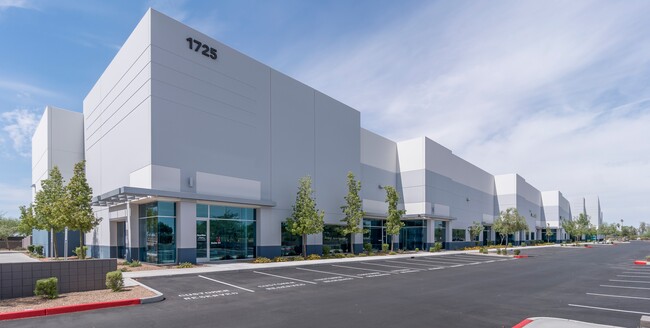
1725 E Germann Rd, Chandler, AZ 85286


Property Detail
1725 E Germann Rd
303-33-981
METRO CHANDLER AIRPORT CENTER MCR 1267-33
Warehouse
Maricopa
PAD
Arizona
AH Areas with a 1% annual chance of shallow flooding, usually in the form of a pond, withan average depth ranging from 1 to 3 feet. These areas have a 26% chance of flooding over the life of a 30-year mortgage.
1
2025
10.11 AC
2025
Chandler Airport
812400
Phoenix
122,609 SF
Phoenix-Mesa-Chandler, AZ
NEARBY LISTINGS FOR SALE OR LEASE
DEMOGRAPHICS near 1725 E Germann Rd
1 mile
3 mile
5 mile
2025 Total Population
6,705
106,924
298,627
2030 Population
7,015
110,605
309,982
Pop Growth 2025-2030
+ 4.62%
+ 3.44%
+ 3.80%
Average Age
36
37
39
2025 Total Households
2,753
36,004
106,692
HH Growth 2025-2030
+ 4.76%
+ 3.52%
+ 3.87%
Median Household Inc
$113,847
$118,014
$114,560
Avg Household Size
2.40
2.90
2.70
2025 Avg HH Vehicles
2.00
2.00
2.00
Median Home Value
$570,652
$615,932
$601,000
Median Year Built
2010
2002
2000
Nearby Places
Map Layers
Map Styles
 Street
 Aerial
Transit
 Traffic
 Biking
Places
Listings with unknown addresses are not visible on the map
- Restaurants
- Banks
- Shops
- Fitness
- Groceries
PUBLIC TRANSPORTATION
AIRPORT
Phoenix-Mesa Gateway
Drive
Walk
Distance
Phoenix-Mesa Gateway
17 min
10.0 mi
Phoenix Sky Harbor International
Drive
Walk
Distance
Phoenix Sky Harbor International
30 min
21.8 mi
Freight Ports
Port of San Diego
Drive
Walk
Distance
Port of San Diego
400 min
364.9 mi
SALE & LEASE HISTORY
LISTING DATE
SALE/LEASE

Sep 25, 2016
For Lease
Mar 13, 2023
For Lease
Jul 02, 2024
For Lease
Nearby Properties
Address
Land Use
TOTAL SIZE
Lot Size
Zoning
Address
Land Use
TOTAL SIZE
Lot Size
Zoning
10.02 AC
Address
Land Use
TOTAL SIZE
Lot Size
Zoning
1.13 AC
Address
Land Use
TOTAL SIZE
Lot Size
Zoning
30,414 SF
97.19 AC
PAD
Address
Land Use
TOTAL SIZE
Lot Size
Zoning
434,857 SF
36.73 AC
PF
Address
Land Use
TOTAL SIZE
Lot Size
Zoning
1.83 AC
Address
Land Use
TOTAL SIZE
Lot Size
Zoning
288,023 SF
48.20 AC
PAD
Address
Land Use
TOTAL SIZE
Lot Size
Zoning
498,377 SF
29.12 AC
Address
Land Use
TOTAL SIZE
Lot Size
Zoning
1.64 AC
Address
Land Use
TOTAL SIZE
Lot Size
Zoning
263,599 SF
18.33 AC
PAD
Address
Land Use
TOTAL SIZE
Lot Size
Zoning
416,954 SF
9.59 AC
PF
Address
Land Use
TOTAL SIZE
Lot Size
Zoning
416,098 SF
22.48 AC
Address
Land Use
TOTAL SIZE
Lot Size
Zoning
348,249 SF
6.42 AC
M-H
Address
Land Use
TOTAL SIZE
Lot Size
Zoning
363,785 SF
46.73 AC
Address
Land Use
TOTAL SIZE
Lot Size
Zoning
374,847 SF
20.84 AC
PAD
Address
Land Use
TOTAL SIZE
Lot Size
Zoning
445,862 SF
36.70 AC
LI
Address
Land Use
TOTAL SIZE
Lot Size
Zoning
563,460 SF
33.65 AC
Address
Land Use
TOTAL SIZE
Lot Size
Zoning
425,886 SF
19.08 AC
MFM
Address
Land Use
TOTAL SIZE
Lot Size
Zoning
465,645 SF
30.78 AC
PAD
Address
Land Use
TOTAL SIZE
Lot Size
Zoning
300,885 SF
37.63 AC
AG
Address
Land Use
TOTAL SIZE
Lot Size
Zoning
444,707 SF
21.62 AC
I-2
Address
Land Use
TOTAL SIZE
Lot Size
Zoning
329,305 SF
18.06 AC
PAD
Address
Land Use
TOTAL SIZE
Lot Size
Zoning
308,238 SF
36.64 AC
PAD
Address
Land Use
TOTAL SIZE
Lot Size
Zoning
324,283 SF
18.75 AC
PAD
Address
Land Use
TOTAL SIZE
Lot Size
Zoning
180,117 SF
28.41 AC
PF
Address
Land Use
TOTAL SIZE
Lot Size
Zoning
317,959 SF
23.86 AC
Address
Land Use
TOTAL SIZE
Lot Size
Zoning
159,419 SF
10.11 AC
RC
Address
Land Use
TOTAL SIZE
Lot Size
Zoning
199,808 SF
48.05 AC
PAD
Address
Land Use
TOTAL SIZE
Lot Size
Zoning
316,658 SF
47.91 AC
PAD
Address
Land Use
TOTAL SIZE
Lot Size
Zoning
128,416 SF
8.28 AC
C-BP
Address
Land Use
TOTAL SIZE
Lot Size
Zoning
325,445 SF
15.28 AC
PAD
The World's #1 Commercial Real Estate Marketplace
Connect with us
© 2026 CoStar Group
The information above has been obtained from sources believed reliable. While we do not doubt its accuracy we have not verified it and make no guarantee, warranty or representation about it. It is your responsibility to independently confirm its accuracy and completeness. Any projections, opinions, assumptions, or estimates used are for example only and do not represent the current or future performance of the property. The value of this transaction to you depends on tax and other factors which should be evaluated by your tax, financial, and legal advisors. You and your advisors should conduct a careful, independent investigation of the property to determine to your satisfaction the suitability of the property for your needs.