Property Record
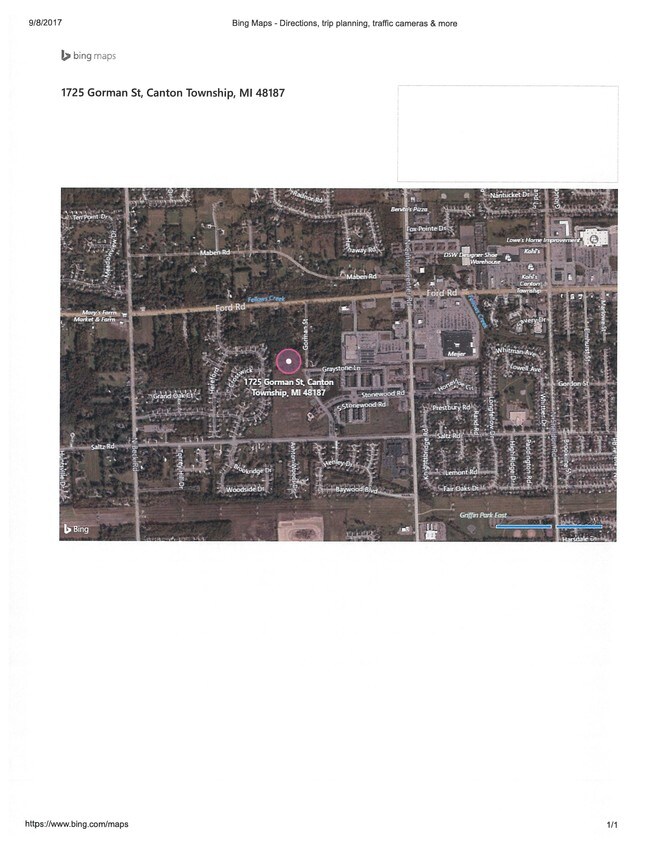
1725 Gorman St, Canton, MI 48187


Save to a Folder
{{folder.Name}}
{{folder.ListingIds.length}} Properties
{{folder.ListingIds.length}} Property
Create a New Folder
This Property Is For Sale
Property Detail
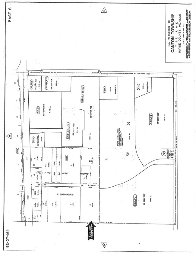
1725 Gorman St
Detroit-Warren-Dearborn, MI
16A6 LOT 6 SUPERVISORS CANTON PLAT NO 1 T2S R8E L64 P86 WCR
71-036-01-0006-000
WAYNE
Residentialacreage
Michigan
R-1
6
B and X Area of moderate flood hazard, usually the area between the limits of the 100-year and 500-year floods.
4.90 AC
2025
Southern I-275 Corridor
2025
Detroit
564402
NEARBY LISTINGS FOR SALE OR LEASE
DEMOGRAPHICS near 1725 Gorman St
1 mile
3 mile
5 mile
2025 Total Population
8,667
79,807
152,842
2030 Population
8,621
78,414
150,388
Pop Growth 2025-2030
(0.53%)
(1.75%)
(1.61%)
Average Age
41
41
41
2025 Total Households
3,066
28,566
59,475
HH Growth 2025-2030
(0.42%)
(1.78%)
(1.62%)
Median Household Inc
$143,993
$127,980
$107,184
Avg Household Size
2.80
2.70
2.50
2025 Avg HH Vehicles
2.00
2.00
2.00
Median Home Value
$385,155
$376,602
$348,460
Median Year Built
1993
1990
1985
Nearby Places
Map Layers
Map Styles
 Street
 Aerial
Layers
 Traffic
 Biking
Places
Listings with unknown addresses are not visible on the map
- Restaurants
- Banks
- Shops
- Fitness
- Groceries
PUBLIC TRANSPORTATION
AIRPORT
Detroit Metro Wayne County
Drive
Walk
Distance
Detroit Metro Wayne County
22 min
16.3 mi
Windsor International
Drive
Walk
Distance
Windsor International
59 min
39.7 mi
Freight Ports
Port of Toledo
Drive
Walk
Distance
Port of Toledo
72 min
57.9 mi
Nearby Properties
Address
Land Use
TOTAL SIZE
Lot Size
Zoning
Address
Land Use
TOTAL SIZE
Lot Size
Zoning
17.50 AC
R-2
Address
Land Use
TOTAL SIZE
Lot Size
Zoning
400,857 SF
27.44 AC
RP
Address
Land Use
TOTAL SIZE
Lot Size
Zoning
176,796 SF
17.08 AC
C-2
Address
Land Use
TOTAL SIZE
Lot Size
Zoning
167,491 SF
18.59 AC
Address
Land Use
TOTAL SIZE
Lot Size
Zoning
21.71 AC
MR
Address
Land Use
TOTAL SIZE
Lot Size
Zoning
311,556 SF
23.17 AC
C-3
Address
Land Use
TOTAL SIZE
Lot Size
Zoning
24.63 AC
MR
Address
Land Use
TOTAL SIZE
Lot Size
Zoning
20.91 AC
Address
Land Use
TOTAL SIZE
Lot Size
Zoning
206,896 SF
19.49 AC
R-6
Address
Land Use
TOTAL SIZE
Lot Size
Zoning
190,344 SF
18.24 AC
R-6
Address
Land Use
TOTAL SIZE
Lot Size
Zoning
123,225 SF
9 AC
CJ/ARC
Address
Land Use
TOTAL SIZE
Lot Size
Zoning
Address
Land Use
TOTAL SIZE
Lot Size
Zoning
169,968 SF
12.46 AC
MR
Address
Land Use
TOTAL SIZE
Lot Size
Zoning
186,967 SF
9.75 AC
Address
Land Use
TOTAL SIZE
Lot Size
Zoning
11.40 AC
MR
Address
Land Use
TOTAL SIZE
Lot Size
Zoning
147,968 SF
16.68 AC
Address
Land Use
TOTAL SIZE
Lot Size
Zoning
66,670 SF
11.20 AC
C-3
Address
Land Use
TOTAL SIZE
Lot Size
Zoning
269,649 SF
18.27 AC
LI-1
Address
Land Use
TOTAL SIZE
Lot Size
Zoning
78,205 SF
14.66 AC
RR
Address
Land Use
TOTAL SIZE
Lot Size
Zoning
100,098 SF
10.52 AC
C-2
Address
Land Use
TOTAL SIZE
Lot Size
Zoning
73,056 SF
7.44 AC
C-3
Address
Land Use
TOTAL SIZE
Lot Size
Zoning
187,281 SF
26.35 AC
C-2
Address
Land Use
TOTAL SIZE
Lot Size
Zoning
51,550 SF
6.49 AC
O-1
Address
Land Use
TOTAL SIZE
Lot Size
Zoning
5.80 AC
MR
Address
Land Use
TOTAL SIZE
Lot Size
Zoning
85,612 SF
17.66 AC
R-1
Address
Land Use
TOTAL SIZE
Lot Size
Zoning
17.38 AC
MR
Address
Land Use
TOTAL SIZE
Lot Size
Zoning
5.43 AC
R-2
Address
Land Use
TOTAL SIZE
Lot Size
Zoning
14.32 AC
R-6
Address
Land Use
TOTAL SIZE
Lot Size
Zoning
6.44 AC
R-2
Address
Land Use
TOTAL SIZE
Lot Size
Zoning
41.45 AC
C-3
The World's #1 Commercial Real Estate Marketplace
Connect with us
© 2026 CoStar Group
The information above has been obtained from sources believed reliable. While we do not doubt its accuracy we have not verified it and make no guarantee, warranty or representation about it. It is your responsibility to independently confirm its accuracy and completeness. Any projections, opinions, assumptions, or estimates used are for example only and do not represent the current or future performance of the property. The value of this transaction to you depends on tax and other factors which should be evaluated by your tax, financial, and legal advisors. You and your advisors should conduct a careful, independent investigation of the property to determine to your satisfaction the suitability of the property for your needs.