Property Record
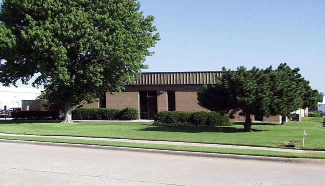
1725 Jay Ell Dr, Richardson, TX 75081

NEARBY LISTINGS FOR SALE OR LEASE
Property Detail
1725 Jay Ell Dr
Dallas-Fort Worth-Arlington, TX
Central Park
420415000B0010000
CENTRAL PARK BLK B LT 1 ACS 1.670 INT200503627552 DD12052005 CO-DC 0415000B00100 3CR0415000B
Warehouse
Dallas
X
Texas
48085C0505K
1
2024
1.67 AC
2025
Richardson
019053
Dallas/Ft Worth
19,385 SF
DEMOGRAPHICS near 1725 Jay Ell Dr
1 Mile
3 Mile
5 Mile
2024 Total Population
6,616
119,141
386,081
2029 Population
6,662
125,412
411,277
Pop Growth 2024-2029
+ 0.70%
+ 5.26%
+ 6.53%
Average Age
37
38
38
2024 Total Households
3,197
46,215
149,422
HH Growth 2024-2029
+ 0.59%
+ 6.48%
+ 7.20%
Median Household Inc
$79,917
$82,697
$68,186
Avg Household Size
2.00
2.40
2.50
2024 Avg HH Vehicles
2.00
2.00
2.00
Median Home Value
$459,130
$324,776
$328,840
Median Year Built
2000
1980
1981
Nearby Places
Map Layers
Map Styles
 Street
 Aerial
- Restaurants
- Banks
- Shops
- Fitness
- Groceries
PUBLIC TRANSPORTATION
AIRPORT
Dallas Love Field
DRIVE
WALK
Distance
Dallas Love Field
26 min
17.0 mi
Dallas-Fort Worth International
DRIVE
WALK
Distance
Dallas-Fort Worth International
33 min
25.8 mi
Nearby Properties
Address
Land Use
TOTAL SIZE
Lot Size
Zoning
Address
Land Use
TOTAL SIZE
Lot Size
Zoning
1,049,441 SF
Address
Land Use
TOTAL SIZE
Lot Size
Zoning
1,283,376 SF
11.62 AC
Address
Land Use
TOTAL SIZE
Lot Size
Zoning
1,050,550 SF
18.24 AC
Address
Land Use
TOTAL SIZE
Lot Size
Zoning
641,243 SF
20.67 AC
Z109
Address
Land Use
TOTAL SIZE
Lot Size
Zoning
766,245 SF
49.94 AC
COMM
Address
Land Use
TOTAL SIZE
Lot Size
Zoning
567,715 SF
4.75 AC
LC/PD-A
Address
Land Use
TOTAL SIZE
Lot Size
Zoning
1,105,509 SF
92.46 AC
A
Address
Land Use
TOTAL SIZE
Lot Size
Zoning
686,032 SF
9 AC
R2000
Address
Land Use
TOTAL SIZE
Lot Size
Zoning
369,694 SF
Address
Land Use
TOTAL SIZE
Lot Size
Zoning
384,538 SF
2.63 AC
LI-1
Address
Land Use
TOTAL SIZE
Lot Size
Zoning
490,285 SF
29.66 AC
LC/PD-A
Address
Land Use
TOTAL SIZE
Lot Size
Zoning
445,071 SF
107.94 AC
2493-A TO-
Address
Land Use
TOTAL SIZE
Lot Size
Zoning
595,150 SF
17.20 AC
MF-H
Address
Land Use
TOTAL SIZE
Lot Size
Zoning
487,093 SF
6.28 AC
MF-E
Address
Land Use
TOTAL SIZE
Lot Size
Zoning
394,287 SF
14.96 AC
Address
Land Use
TOTAL SIZE
Lot Size
Zoning
507,693 SF
32.50 AC
MFL
Address
Land Use
TOTAL SIZE
Lot Size
Zoning
393,416 SF
Address
Land Use
TOTAL SIZE
Lot Size
Zoning
377,152 SF
3.91 AC
O-S
Address
Land Use
TOTAL SIZE
Lot Size
Zoning
428,956 SF
18.76 AC
Z291
Address
Land Use
TOTAL SIZE
Lot Size
Zoning
509,566 SF
34.05 AC
PD
Address
Land Use
TOTAL SIZE
Lot Size
Zoning
289,093 SF
8.87 AC
R/O-2
Address
Land Use
TOTAL SIZE
Lot Size
Zoning
284,830 SF
2.98 AC
Address
Land Use
TOTAL SIZE
Lot Size
Zoning
386,448 SF
Address
Land Use
TOTAL SIZE
Lot Size
Zoning
324,000 SF
6.67 AC
O-S
Address
Land Use
TOTAL SIZE
Lot Size
Zoning
129,810 SF
14.93 AC
Z236
Address
Land Use
TOTAL SIZE
Lot Size
Zoning
421,532 SF
4.29 AC
Address
Land Use
TOTAL SIZE
Lot Size
Zoning
795,714 SF
5.36 AC
Z109
Address
Land Use
TOTAL SIZE
Lot Size
Zoning
296,337 SF
3.28 AC
Address
Land Use
TOTAL SIZE
Lot Size
Zoning
355,408 SF
3.08 AC
LI-1
The World's #1 Commercial Real Estate Marketplace
Connect with us
© 2025 CoStar Group
The information above has been obtained from sources believed reliable. While we do not doubt its accuracy we have not verified it and make no guarantee, warranty or representation about it. It is your responsibility to independently confirm its accuracy and completeness. Any projections, opinions, assumptions, or estimates used are for example only and do not represent the current or future performance of the property. The value of this transaction to you depends on tax and other factors which should be evaluated by your tax, financial, and legal advisors. You and your advisors should conduct a careful, independent investigation of the property to determine to your satisfaction the suitability of the property for your needs.