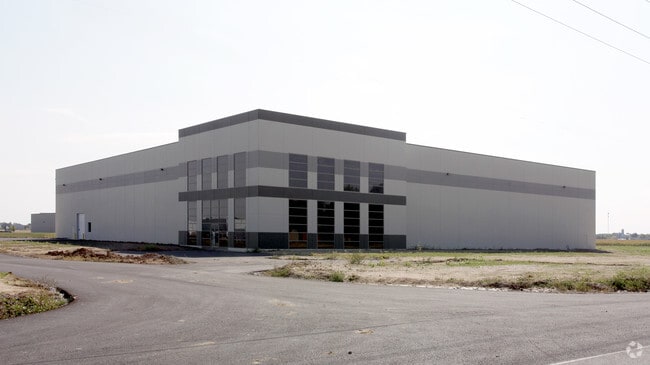
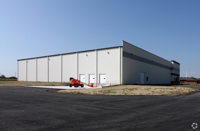
Property Record
1725 N Graham Rd, Franklin, IN 46131
NEARBY LISTINGS FOR SALE OR LEASE
Property Detail
1725 N Graham Rd
Indianapolis-Carmel-Anderson, IN
Franklin Bus Park
41-08-11-042-002.000-009
FRANKLIN BUSINESS PARK LOT 1 MP FRANKLIN COMMUNI
Warehouse
Johnson
X
Indiana
18081C0231E
1
2024
11.20 AC
2025
Johnson County
610802
Indianapolis
52,284 SF
DEMOGRAPHICS near 1725 N Graham Rd
1 Mile
3 Mile
5 Mile
2024 Total Population
6,852
27,648
40,310
2029 Population
7,320
29,588
43,153
Pop Growth 2024-2029
+ 6.83%
+ 7.02%
+ 7.05%
Average Age
38
40
39
2024 Total Households
2,575
10,232
14,822
HH Growth 2024-2029
+ 6.95%
+ 7.18%
+ 7.20%
Median Household Inc
$71,617
$69,647
$72,800
Avg Household Size
2.60
2.50
2.60
2024 Avg HH Vehicles
2.00
2.00
2.00
Median Home Value
$180,240
$189,560
$182,068
Median Year Built
1988
1991
1990
Nearby Places
Map Layers
Map Styles
 Street
 Aerial
- Restaurants
- Banks
- Shops
- Fitness
- Groceries
PUBLIC TRANSPORTATION
AIRPORT
Indianapolis International
DRIVE
WALK
Distance
Indianapolis International
44 min
33.5 mi
SALE & LEASE HISTORY
LISTING DATE
SALE/LEASE

Sep 24, 2016
For Sale
Nov 16, 2016
For Sale
May 24, 2019
For Sale
Jan 07, 2019
For Sale
Nearby Properties
Address
Land Use
TOTAL SIZE
Lot Size
Zoning
Address
Land Use
TOTAL SIZE
Lot Size
Zoning
2,908 SF
216.91 AC
Address
Land Use
TOTAL SIZE
Lot Size
Zoning
1,103,760 SF
84.07 AC
Address
Land Use
TOTAL SIZE
Lot Size
Zoning
35,382 SF
42.11 AC
Address
Land Use
TOTAL SIZE
Lot Size
Zoning
933,504 SF
42.07 AC
Address
Land Use
TOTAL SIZE
Lot Size
Zoning
588,200 SF
44.31 AC
Address
Land Use
TOTAL SIZE
Lot Size
Zoning
806,916 SF
42.56 AC
Address
Land Use
TOTAL SIZE
Lot Size
Zoning
519,376 SF
53.98 AC
Address
Land Use
TOTAL SIZE
Lot Size
Zoning
553,152 SF
35.86 AC
Address
Land Use
TOTAL SIZE
Lot Size
Zoning
160.96 AC
PUD
Address
Land Use
TOTAL SIZE
Lot Size
Zoning
18.95 AC
Address
Land Use
TOTAL SIZE
Lot Size
Zoning
8,504 SF
31.42 AC
Address
Land Use
TOTAL SIZE
Lot Size
Zoning
1,792 SF
66.50 AC
Address
Land Use
TOTAL SIZE
Lot Size
Zoning
146,505 SF
30.71 AC
Address
Land Use
TOTAL SIZE
Lot Size
Zoning
232,709 SF
51.30 AC
Address
Land Use
TOTAL SIZE
Lot Size
Zoning
193,378 SF
20.55 AC
Address
Land Use
TOTAL SIZE
Lot Size
Zoning
7,304 SF
15.32 AC
Address
Land Use
TOTAL SIZE
Lot Size
Zoning
136,760 SF
31.47 AC
Address
Land Use
TOTAL SIZE
Lot Size
Zoning
119,499 SF
11.54 AC
Address
Land Use
TOTAL SIZE
Lot Size
Zoning
54,436 SF
18.83 AC
Address
Land Use
TOTAL SIZE
Lot Size
Zoning
207,310 SF
17.20 AC
Address
Land Use
TOTAL SIZE
Lot Size
Zoning
20.19 AC
Address
Land Use
TOTAL SIZE
Lot Size
Zoning
86,082 SF
8.14 AC
Address
Land Use
TOTAL SIZE
Lot Size
Zoning
193,690 SF
47 AC
Address
Land Use
TOTAL SIZE
Lot Size
Zoning
2,516 SF
7.87 AC
Address
Land Use
TOTAL SIZE
Lot Size
Zoning
2,304 SF
14.05 AC
Address
Land Use
TOTAL SIZE
Lot Size
Zoning
66,906 SF
2.92 AC
Address
Land Use
TOTAL SIZE
Lot Size
Zoning
119,416 SF
11.51 AC
Address
Land Use
TOTAL SIZE
Lot Size
Zoning
26,208 SF
3.74 AC
PUD
Address
Land Use
TOTAL SIZE
Lot Size
Zoning
539,190 SF
33.27 AC
Address
Land Use
TOTAL SIZE
Lot Size
Zoning
39.94 AC
PUD
The World's #1 Commercial Real Estate Marketplace
Connect with us
© 2026 CoStar Group
The information above has been obtained from sources believed reliable. While we do not doubt its accuracy we have not verified it and make no guarantee, warranty or representation about it. It is your responsibility to independently confirm its accuracy and completeness. Any projections, opinions, assumptions, or estimates used are for example only and do not represent the current or future performance of the property. The value of this transaction to you depends on tax and other factors which should be evaluated by your tax, financial, and legal advisors. You and your advisors should conduct a careful, independent investigation of the property to determine to your satisfaction the suitability of the property for your needs.