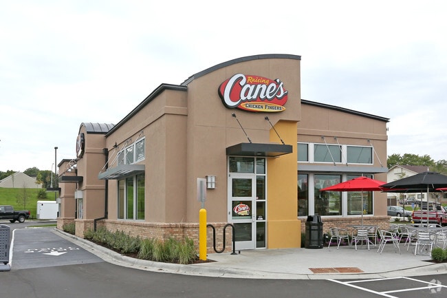
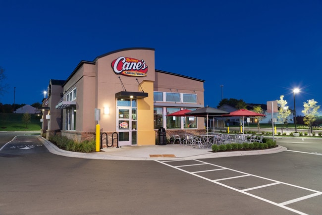
Property Record
1715 Robert St S, Saint Paul, MN 55118

NEARBY LISTINGS FOR SALE OR LEASE
Property Detail
1715 Robert St S
Minneapolis-St. Paul-Bloomington, MN-WI
Robert Street Riley Addition
42-64780-01-010
ROBERT STREET RILEY ADDITION 1 1
Commercialnec
Dakota
X
Minnesota
27037C0040E
10
2023
1.01 AC
2024
West St Paul
060104
Minneapolis/St Paul
2,905 SF
DEMOGRAPHICS near 1715 Robert St S
1 Mile
3 Mile
5 Mile
2024 Total Population
11,436
75,749
220,349
2029 Population
11,843
76,770
219,544
Pop Growth 2024-2029
+ 3.56%
+ 1.35%
(0.37%)
Average Age
42
40
39
2024 Total Households
5,494
31,314
91,778
HH Growth 2024-2029
+ 3.86%
+ 1.50%
(0.38%)
Median Household Inc
$52,553
$73,435
$70,772
Avg Household Size
2.00
2.30
2.30
2024 Avg HH Vehicles
1.00
2.00
2.00
Median Home Value
$271,457
$277,072
$294,863
Median Year Built
1977
1968
1965
Nearby Places
Map Layers
Map Styles
 Street
 Aerial
- Restaurants
- Banks
- Shops
- Fitness
- Groceries
PUBLIC TRANSPORTATION
COMMUTER RAIL
St. Paul-Minneapolis (Empire Builder - Amtrak)
DRIVE
WALK
Distance
St. Paul-Minneapolis (Empire Builder - Amtrak)
9 min
4.2 mi
AIRPORT
Minneapolis-St Paul International/Wold-Chamberlain
DRIVE
WALK
Distance
Minneapolis-St Paul International/Wold-Chamberlain
16 min
9.1 mi
Freight Ports
Port Milwaukee
DRIVE
WALK
Distance
Port Milwaukee
367 min
332.7 mi
SALE & LEASE HISTORY
LISTING DATE
SALE/LEASE

Oct 24, 2017
For Sale
Nearby Properties
Address
Land Use
TOTAL SIZE
Lot Size
Zoning
Address
Land Use
TOTAL SIZE
Lot Size
Zoning
63.12 AC
Address
Land Use
TOTAL SIZE
Lot Size
Zoning
Address
Land Use
TOTAL SIZE
Lot Size
Zoning
146,085 SF
46.83 AC
Address
Land Use
TOTAL SIZE
Lot Size
Zoning
329,070 SF
5.75 AC
Address
Land Use
TOTAL SIZE
Lot Size
Zoning
265,736 SF
6.67 AC
Address
Land Use
TOTAL SIZE
Lot Size
Zoning
247,470 SF
2.21 AC
Address
Land Use
TOTAL SIZE
Lot Size
Zoning
217,703 SF
3.51 AC
Address
Land Use
TOTAL SIZE
Lot Size
Zoning
293,970 SF
31.92 AC
Address
Land Use
TOTAL SIZE
Lot Size
Zoning
381,158 SF
11.86 AC
Address
Land Use
TOTAL SIZE
Lot Size
Zoning
317,235 SF
32.38 AC
Address
Land Use
TOTAL SIZE
Lot Size
Zoning
228,050 SF
0.32 AC
Address
Land Use
TOTAL SIZE
Lot Size
Zoning
243,847 SF
5.24 AC
Address
Land Use
TOTAL SIZE
Lot Size
Zoning
245,570 SF
2.85 AC
Address
Land Use
TOTAL SIZE
Lot Size
Zoning
210,540 SF
5.35 AC
Address
Land Use
TOTAL SIZE
Lot Size
Zoning
Address
Land Use
TOTAL SIZE
Lot Size
Zoning
163,985 SF
7.06 AC
Address
Land Use
TOTAL SIZE
Lot Size
Zoning
381,395 SF
15.31 AC
Address
Land Use
TOTAL SIZE
Lot Size
Zoning
163,561 SF
41.09 AC
Address
Land Use
TOTAL SIZE
Lot Size
Zoning
293,717 SF
33.30 AC
Address
Land Use
TOTAL SIZE
Lot Size
Zoning
482,008 SF
23.78 AC
Address
Land Use
TOTAL SIZE
Lot Size
Zoning
452,836 SF
17.81 AC
Address
Land Use
TOTAL SIZE
Lot Size
Zoning
Address
Land Use
TOTAL SIZE
Lot Size
Zoning
229,442 SF
9.50 AC
Address
Land Use
TOTAL SIZE
Lot Size
Zoning
163,847 SF
2.97 AC
Address
Land Use
TOTAL SIZE
Lot Size
Zoning
532,778 SF
4.99 AC
Address
Land Use
TOTAL SIZE
Lot Size
Zoning
160,669 SF
5.10 AC
Address
Land Use
TOTAL SIZE
Lot Size
Zoning
Address
Land Use
TOTAL SIZE
Lot Size
Zoning
41,040 SF
11.38 AC
Address
Land Use
TOTAL SIZE
Lot Size
Zoning
Address
Land Use
TOTAL SIZE
Lot Size
Zoning
236,378 SF
7.57 AC
The World's #1 Commercial Real Estate Marketplace
Connect with us
© 2026 CoStar Group
The information above has been obtained from sources believed reliable. While we do not doubt its accuracy we have not verified it and make no guarantee, warranty or representation about it. It is your responsibility to independently confirm its accuracy and completeness. Any projections, opinions, assumptions, or estimates used are for example only and do not represent the current or future performance of the property. The value of this transaction to you depends on tax and other factors which should be evaluated by your tax, financial, and legal advisors. You and your advisors should conduct a careful, independent investigation of the property to determine to your satisfaction the suitability of the property for your needs.