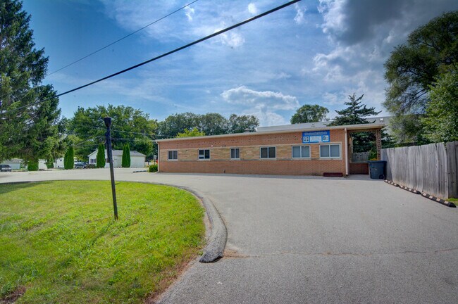
Property Record
1725 S Fairview Ave, Decatur, IL 62521


Save to a Folder
{{folder.Name}}
{{folder.ListingIds.length}} Properties
{{folder.ListingIds.length}} Property
Create a New Folder
Property Detail
1725 S Fairview Ave
Decatur, IL
SUB PT OF NW1/4 SE1/4 SEC 21 THE N341.81 OF THE E 100 OF LT 1 96BK2638/499
04-12-21-404-006
Macon
Animalhospitalvet
Illinois
MUNICIPAL
1
B and X Area of moderate flood hazard, usually the area between the limits of the 100-year and 500-year floods.
0.84 AC
2025
Springfield/Decatur
2025
Other Market Areas
001500
NEARBY LISTINGS FOR SALE OR LEASE
DEMOGRAPHICS near 1725 S Fairview Ave
1 mile
3 mile
5 mile
2025 Total Population
2,294
38,731
64,587
2030 Population
2,255
38,578
63,881
Pop Growth 2025-2030
(1.70%)
(0.40%)
(1.09%)
Average Age
41
39
41
2025 Total Households
957
16,307
28,228
HH Growth 2025-2030
(1.78%)
(0.43%)
(1.17%)
Median Household Inc
$52,083
$44,470
$47,792
Avg Household Size
2.20
2.20
2.10
2025 Avg HH Vehicles
2.00
2.00
2.00
Median Home Value
$88,051
$82,159
$90,752
Median Year Built
1953
1954
1958
Nearby Places
Map Layers
Map Styles
 Street
 Aerial
Layers
 Traffic
 Biking
Places
Listings with unknown addresses are not visible on the map
- Restaurants
- Banks
- Shops
- Fitness
- Groceries
SALE & LEASE HISTORY
LISTING DATE
SALE/LEASE

Nov 09, 2017
For Sale
May 26, 2022
For Lease
Jan 15, 2022
For Sale
Nearby Properties
Address
Land Use
TOTAL SIZE
Lot Size
Zoning
Address
Land Use
TOTAL SIZE
Lot Size
Zoning
1.40 AC
MUNICIPAL
Address
Land Use
TOTAL SIZE
Lot Size
Zoning
8.48 AC
MUNICIPAL
Address
Land Use
TOTAL SIZE
Lot Size
Zoning
Address
Land Use
TOTAL SIZE
Lot Size
Zoning
6.68 AC
MUNICIPAL
Address
Land Use
TOTAL SIZE
Lot Size
Zoning
7.82 AC
MUNICIPAL
Address
Land Use
TOTAL SIZE
Lot Size
Zoning
1.10 AC
MUNICIPAL
Address
Land Use
TOTAL SIZE
Lot Size
Zoning
3.93 AC
MUNICIPAL
Address
Land Use
TOTAL SIZE
Lot Size
Zoning
1.72 AC
MUNICIPAL
Address
Land Use
TOTAL SIZE
Lot Size
Zoning
4.30 AC
MUNICIPAL
Address
Land Use
TOTAL SIZE
Lot Size
Zoning
14.33 AC
MUNICIPAL
Address
Land Use
TOTAL SIZE
Lot Size
Zoning
0.73 AC
MUNICIPAL
Address
Land Use
TOTAL SIZE
Lot Size
Zoning
4 AC
MUNICIPAL
Address
Land Use
TOTAL SIZE
Lot Size
Zoning
Address
Land Use
TOTAL SIZE
Lot Size
Zoning
2.62 AC
MUNICIPAL
Address
Land Use
TOTAL SIZE
Lot Size
Zoning
7.55 AC
MUNICIPAL
Address
Land Use
TOTAL SIZE
Lot Size
Zoning
2.59 AC
MUNICIPAL
Address
Land Use
TOTAL SIZE
Lot Size
Zoning
1 AC
MUNICIPAL
Address
Land Use
TOTAL SIZE
Lot Size
Zoning
4.38 AC
MUNICIPAL
Address
Land Use
TOTAL SIZE
Lot Size
Zoning
3.54 AC
MUNICIPAL
Address
Land Use
TOTAL SIZE
Lot Size
Zoning
1.54 AC
MUNICIPAL
Address
Land Use
TOTAL SIZE
Lot Size
Zoning
2.50 AC
MUNICIPAL
Address
Land Use
TOTAL SIZE
Lot Size
Zoning
0.45 AC
MUNICIPAL
Address
Land Use
TOTAL SIZE
Lot Size
Zoning
13.97 AC
MUNICIPAL
Address
Land Use
TOTAL SIZE
Lot Size
Zoning
16.25 AC
MUNICIPAL
Address
Land Use
TOTAL SIZE
Lot Size
Zoning
26.06 AC
MUNICIPAL
Address
Land Use
TOTAL SIZE
Lot Size
Zoning
6.81 AC
MUNICIPAL
Address
Land Use
TOTAL SIZE
Lot Size
Zoning
0.55 AC
MUNICIPAL
Address
Land Use
TOTAL SIZE
Lot Size
Zoning
0.72 AC
MUNICIPAL
The World's #1 Commercial Real Estate Marketplace
Connect with us
© 2026 CoStar Group
The information above has been obtained from sources believed reliable. While we do not doubt its accuracy we have not verified it and make no guarantee, warranty or representation about it. It is your responsibility to independently confirm its accuracy and completeness. Any projections, opinions, assumptions, or estimates used are for example only and do not represent the current or future performance of the property. The value of this transaction to you depends on tax and other factors which should be evaluated by your tax, financial, and legal advisors. You and your advisors should conduct a careful, independent investigation of the property to determine to your satisfaction the suitability of the property for your needs.