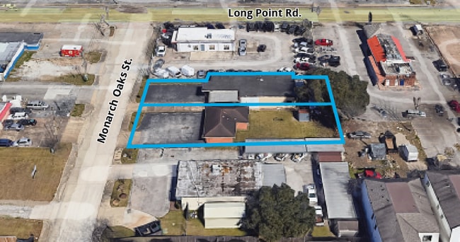
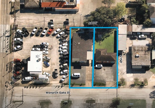
Property Record
1726 Monarch Oaks St, Houston, TX 77055
NEARBY LISTINGS FOR SALE OR LEASE
-
-
No Photo
-
-
-
-
-
-
-
-
-
-
-
-
-
-
-
-
-
View all Houston listings for sale on LoopNet.com
Property Detail
1726 Monarch Oaks St
Houston-The Woodlands-Sugar Land, TX
Monarch Oaks
0761070020017
N 1/2 LT 2 BLK 2 MONARCH OAKS
Sfr
Harris
X
Texas
48201C0665M
2
2024
0.17 AC
2025
Katy Freeway East
520700
Houston
750 SF
DEMOGRAPHICS near 1726 Monarch Oaks St
1 Mile
3 Mile
5 Mile
2024 Total Population
22,857
136,318
402,809
2029 Population
23,467
140,881
416,387
Pop Growth 2024-2029
+ 2.67%
+ 3.35%
+ 3.37%
Average Age
36
37
38
2024 Total Households
8,161
51,802
171,552
HH Growth 2024-2029
+ 2.73%
+ 3.43%
+ 3.51%
Median Household Inc
$59,231
$61,836
$74,117
Avg Household Size
2.70
2.50
2.30
2024 Avg HH Vehicles
2.00
2.00
2.00
Median Home Value
$510,138
$398,057
$421,094
Median Year Built
1977
1976
1982
Nearby Places
Map Layers
Map Styles
 Street
 Aerial
- Restaurants
- Banks
- Shops
- Fitness
- Groceries
PUBLIC TRANSPORTATION
AIRPORT
William P Hobby
DRIVE
WALK
Distance
William P Hobby
36 min
22.6 mi
George Bush Intcntl/Houston
DRIVE
WALK
Distance
George Bush Intcntl/Houston
32 min
24.0 mi
Freight Ports
Port of Houston
DRIVE
WALK
Distance
Port of Houston
30 min
19.3 mi
SALE & LEASE HISTORY
LISTING DATE
SALE/LEASE

May 11, 2023
For Sale
Nearby Properties
Address
Land Use
TOTAL SIZE
Lot Size
Zoning
Address
Land Use
TOTAL SIZE
Lot Size
Zoning
743,954 SF
2.97 AC
Address
Land Use
TOTAL SIZE
Lot Size
Zoning
487,073 SF
44.12 AC
Address
Land Use
TOTAL SIZE
Lot Size
Zoning
402,886 SF
17.95 AC
Address
Land Use
TOTAL SIZE
Lot Size
Zoning
497,932 SF
3.97 AC
Address
Land Use
TOTAL SIZE
Lot Size
Zoning
224,114 SF
4.24 AC
Address
Land Use
TOTAL SIZE
Lot Size
Zoning
714,049 SF
25.73 AC
Address
Land Use
TOTAL SIZE
Lot Size
Zoning
504,256 SF
6.09 AC
Address
Land Use
TOTAL SIZE
Lot Size
Zoning
199,423 SF
Address
Land Use
TOTAL SIZE
Lot Size
Zoning
366,386 SF
10.85 AC
Address
Land Use
TOTAL SIZE
Lot Size
Zoning
726,444 SF
7.29 AC
Address
Land Use
TOTAL SIZE
Lot Size
Zoning
375,693 SF
9.16 AC
Address
Land Use
TOTAL SIZE
Lot Size
Zoning
324,600 SF
2.06 AC
Address
Land Use
TOTAL SIZE
Lot Size
Zoning
605,420 SF
7.51 AC
Address
Land Use
TOTAL SIZE
Lot Size
Zoning
350,655 SF
16.76 AC
Address
Land Use
TOTAL SIZE
Lot Size
Zoning
279,934 SF
8 AC
Address
Land Use
TOTAL SIZE
Lot Size
Zoning
721,788 SF
10.14 AC
Address
Land Use
TOTAL SIZE
Lot Size
Zoning
211,190 SF
2.53 AC
Address
Land Use
TOTAL SIZE
Lot Size
Zoning
251,980 SF
2.55 AC
Address
Land Use
TOTAL SIZE
Lot Size
Zoning
292,292 SF
10.36 AC
Address
Land Use
TOTAL SIZE
Lot Size
Zoning
151,313 SF
1.21 AC
Address
Land Use
TOTAL SIZE
Lot Size
Zoning
478,524 SF
5.68 AC
Address
Land Use
TOTAL SIZE
Lot Size
Zoning
750,156 SF
22.95 AC
Address
Land Use
TOTAL SIZE
Lot Size
Zoning
311,485 SF
142.25 AC
Address
Land Use
TOTAL SIZE
Lot Size
Zoning
293,407 SF
9.19 AC
Address
Land Use
TOTAL SIZE
Lot Size
Zoning
378,225 SF
11.51 AC
Address
Land Use
TOTAL SIZE
Lot Size
Zoning
418,456 SF
5.72 AC
Address
Land Use
TOTAL SIZE
Lot Size
Zoning
802,913 SF
27.11 AC
Address
Land Use
TOTAL SIZE
Lot Size
Zoning
247,490 SF
2 AC
Address
Land Use
TOTAL SIZE
Lot Size
Zoning
185,068 SF
21.92 AC
Address
Land Use
TOTAL SIZE
Lot Size
Zoning
387,788 SF
17.95 AC
The World's #1 Commercial Real Estate Marketplace
Connect with us
© 2026 CoStar Group
The information above has been obtained from sources believed reliable. While we do not doubt its accuracy we have not verified it and make no guarantee, warranty or representation about it. It is your responsibility to independently confirm its accuracy and completeness. Any projections, opinions, assumptions, or estimates used are for example only and do not represent the current or future performance of the property. The value of this transaction to you depends on tax and other factors which should be evaluated by your tax, financial, and legal advisors. You and your advisors should conduct a careful, independent investigation of the property to determine to your satisfaction the suitability of the property for your needs.