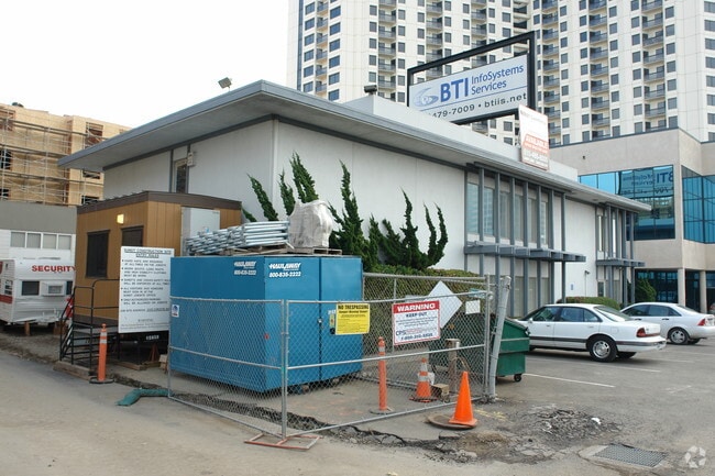
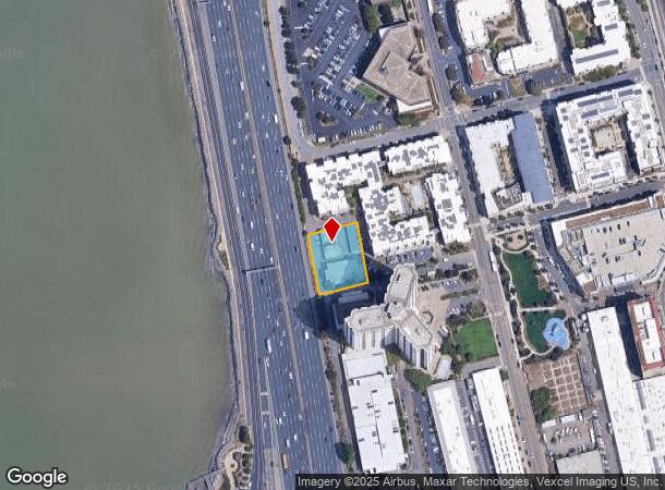
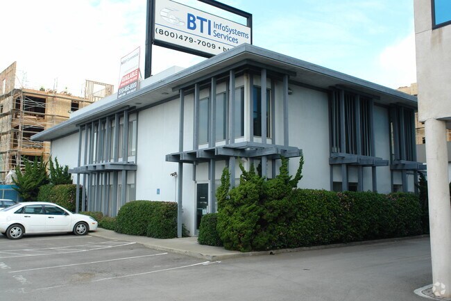
Property Record
1719 64Th St, Emeryville, CA 94608
NEARBY LISTINGS FOR SALE OR LEASE
Property Detail
1719 64Th St
049-1492-001-00
Map No 4 Of Salt Marsh And Tide Land Sit
Officebuilding
LOT: 00001 BLK: AR: 0049 PAGE: 1492
X
Alameda
06001C0058H
California
2024
0.58 AC
2025
Emeryville
425102
East Bay/Oakland
16,023 SF
Oakland-Hayward-Berkeley, CA
DEMOGRAPHICS near 1719 64Th St
1 Mile
3 Mile
5 Mile
2024 Total Population
16,032
217,219
410,647
2029 Population
15,599
212,023
400,496
Pop Growth 2024-2029
(2.70%)
(2.39%)
(2.47%)
Average Age
40
39
40
2024 Total Households
8,062
91,861
171,713
HH Growth 2024-2029
(2.88%)
(2.44%)
(2.53%)
Median Household Inc
$107,327
$93,136
$101,523
Avg Household Size
1.90
2.10
2.20
2024 Avg HH Vehicles
1.00
1.00
1.00
Median Home Value
$811,029
$1,037,142
$1,061,208
Median Year Built
1980
1956
1954
Nearby Places
- Restaurants
- Banks
- Shops
- Fitness
- Groceries
PUBLIC TRANSPORTATION
COMMUTER RAIL
DRIVE
WALK
Distance
4 min
10 min
0.5 mi
DRIVE
WALK
Distance
7 min
3.1 mi
AIRPORT
Metro Oakland International
DRIVE
WALK
Distance
Metro Oakland International
22 min
14.1 mi
San Francisco International
DRIVE
WALK
Distance
San Francisco International
34 min
21.7 mi
Norman Y Mineta San Jose International
DRIVE
WALK
Distance
Norman Y Mineta San Jose International
58 min
45.5 mi
Freight Ports
Port of Oakland
DRIVE
WALK
Distance
Port of Oakland
10 min
5.4 mi
Nearby Properties
Address
Land Use
TOTAL SIZE
Lot Size
Zoning
Address
Land Use
TOTAL SIZE
Lot Size
Zoning
409,266 SF
1.76 AC
Address
Land Use
TOTAL SIZE
Lot Size
Zoning
1,028,501 SF
2.74 AC
Address
Land Use
TOTAL SIZE
Lot Size
Zoning
767,791 SF
1.38 AC
Address
Land Use
TOTAL SIZE
Lot Size
Zoning
373,594 SF
16.16 AC
Address
Land Use
TOTAL SIZE
Lot Size
Zoning
488,781 SF
0.63 AC
Address
Land Use
TOTAL SIZE
Lot Size
Zoning
490,000 SF
1.44 AC
Address
Land Use
TOTAL SIZE
Lot Size
Zoning
432,352 SF
Address
Land Use
TOTAL SIZE
Lot Size
Zoning
525,866 SF
1.38 AC
Address
Land Use
TOTAL SIZE
Lot Size
Zoning
354,263 SF
4.06 AC
Address
Land Use
TOTAL SIZE
Lot Size
Zoning
358,014 SF
5.03 AC
Address
Land Use
TOTAL SIZE
Lot Size
Zoning
423,577 SF
1.04 AC
Address
Land Use
TOTAL SIZE
Lot Size
Zoning
167,071 SF
0.70 AC
Address
Land Use
TOTAL SIZE
Lot Size
Zoning
540,434 SF
14.37 AC
Address
Land Use
TOTAL SIZE
Lot Size
Zoning
621,432 SF
1.31 AC
C
Address
Land Use
TOTAL SIZE
Lot Size
Zoning
395,549 SF
17.05 AC
Address
Land Use
TOTAL SIZE
Lot Size
Zoning
0.73 AC
Address
Land Use
TOTAL SIZE
Lot Size
Zoning
703,758 SF
3.44 AC
Address
Land Use
TOTAL SIZE
Lot Size
Zoning
371,322 SF
1.62 AC
Address
Land Use
TOTAL SIZE
Lot Size
Zoning
240,633 SF
1.59 AC
Address
Land Use
TOTAL SIZE
Lot Size
Zoning
261,134 SF
2.23 AC
Address
Land Use
TOTAL SIZE
Lot Size
Zoning
350,741 SF
1.08 AC
Address
Land Use
TOTAL SIZE
Lot Size
Zoning
169,157 SF
10.20 AC
Address
Land Use
TOTAL SIZE
Lot Size
Zoning
224,160 SF
5.03 AC
Address
Land Use
TOTAL SIZE
Lot Size
Zoning
245,717 SF
0.65 AC
Address
Land Use
TOTAL SIZE
Lot Size
Zoning
303,063 SF
1.27 AC
Address
Land Use
TOTAL SIZE
Lot Size
Zoning
226,800 SF
4.63 AC
Address
Land Use
TOTAL SIZE
Lot Size
Zoning
370,806 SF
2.24 AC
Address
Land Use
TOTAL SIZE
Lot Size
Zoning
177,530 SF
0.46 AC
Address
Land Use
TOTAL SIZE
Lot Size
Zoning
252,080 SF
0.94 AC
Address
Land Use
TOTAL SIZE
Lot Size
Zoning
4.77 AC
The World's #1 Commercial Real Estate Marketplace
Connect with us
© 2025 CoStar Group
The information above has been obtained from sources believed reliable. While we do not doubt its accuracy we have not verified it and make no guarantee, warranty or representation about it. It is your responsibility to independently confirm its accuracy and completeness. Any projections, opinions, assumptions, or estimates used are for example only and do not represent the current or future performance of the property. The value of this transaction to you depends on tax and other factors which should be evaluated by your tax, financial, and legal advisors. You and your advisors should conduct a careful, independent investigation of the property to determine to your satisfaction the suitability of the property for your needs.