Property Record
1711 Bridleton Woods, Fenton, MO 63026
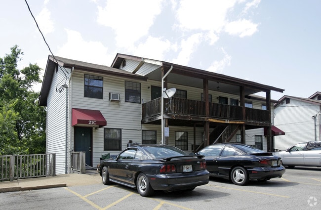
This Property Is For Sale
NEARBY LISTINGS FOR SALE OR LEASE
-
-
View all Fenton listings for sale on LoopNet.com
Property Detail
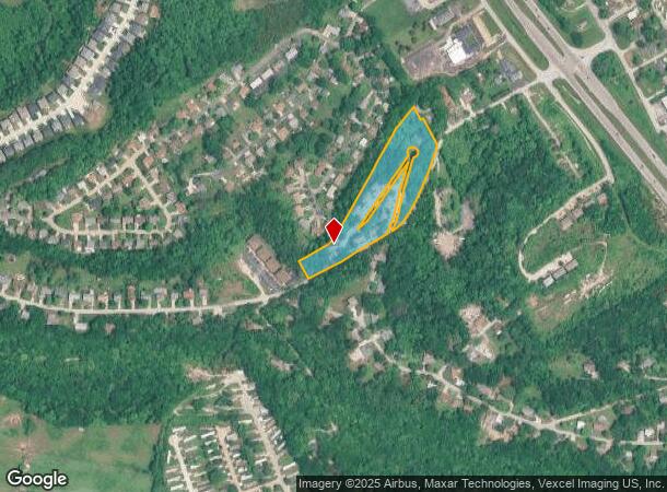
1711 Bridleton Woods
St. Louis, MO-IL
Bridleton Woods
02-2.0-10.0-4-002-064
BRIDLETON WOODS; LTS 1-3 5-10 12-17 PT 11 & BRIDLETON WOODS LT SPLIT; LT 4; & PT USS 3011
Apartment
Jefferson
X
Missouri
29099C0102F
1-3,4
2024
5.70 AC
2025
Fenton
221424
St. Louis
47,294 SF
DEMOGRAPHICS near 1711 Bridleton Woods
1 Mile
3 Mile
5 Mile
2024 Total Population
6,238
35,012
112,958
2029 Population
6,479
35,599
113,963
Pop Growth 2024-2029
+ 3.86%
+ 1.68%
+ 0.89%
Average Age
39
42
42
2024 Total Households
2,433
14,072
44,676
HH Growth 2024-2029
+ 3.99%
+ 1.70%
+ 0.91%
Median Household Inc
$66,915
$74,098
$79,694
Avg Household Size
2.40
2.40
2.50
2024 Avg HH Vehicles
2.00
2.00
2.00
Median Home Value
$172,113
$244,175
$257,048
Median Year Built
1992
1987
1983
Nearby Places
Map Layers
Map Styles
 Street
 Aerial
- Restaurants
- Banks
- Shops
- Fitness
- Groceries
PUBLIC TRANSPORTATION
AIRPORT
St Louis Lambert International
DRIVE
WALK
Distance
St Louis Lambert International
40 min
26.2 mi
Freight Ports
Tulsa Port of Inola
DRIVE
WALK
Distance
Tulsa Port of Inola
411 min
372.2 mi
Nearby Properties
Address
Land Use
TOTAL SIZE
Lot Size
Zoning
Address
Land Use
TOTAL SIZE
Lot Size
Zoning
258,312 SF
16.34 AC
CC2
Address
Land Use
TOTAL SIZE
Lot Size
Zoning
139,212 SF
15.58 AC
21C-1
Address
Land Use
TOTAL SIZE
Lot Size
Zoning
154,844 SF
13.29 AC
21OT-3
Address
Land Use
TOTAL SIZE
Lot Size
Zoning
129,090 SF
17.78 AC
21C-1
Address
Land Use
TOTAL SIZE
Lot Size
Zoning
211,612 SF
41.36 AC
PB
Address
Land Use
TOTAL SIZE
Lot Size
Zoning
221,724 SF
21.98 AC
21OT-4
Address
Land Use
TOTAL SIZE
Lot Size
Zoning
265,291 SF
14.91 AC
PR2
Address
Land Use
TOTAL SIZE
Lot Size
Zoning
164,166 SF
16.88 AC
21C-1
Address
Land Use
TOTAL SIZE
Lot Size
Zoning
118,820 SF
13.30 AC
Address
Land Use
TOTAL SIZE
Lot Size
Zoning
156,592 SF
9.80 AC
PR2
Address
Land Use
TOTAL SIZE
Lot Size
Zoning
90,300 SF
9.42 AC
21OT-3
Address
Land Use
TOTAL SIZE
Lot Size
Zoning
94,421 SF
10.94 AC
21OT-2
Address
Land Use
TOTAL SIZE
Lot Size
Zoning
134,885 SF
16.91 AC
21C-1
Address
Land Use
TOTAL SIZE
Lot Size
Zoning
125,762 SF
10.42 AC
21C-1
Address
Land Use
TOTAL SIZE
Lot Size
Zoning
15.82 AC
NU
Address
Land Use
TOTAL SIZE
Lot Size
Zoning
85,150 SF
8.62 AC
21R-6A
Address
Land Use
TOTAL SIZE
Lot Size
Zoning
88,379 SF
8.97 AC
C-8
Address
Land Use
TOTAL SIZE
Lot Size
Zoning
41,284 SF
5.25 AC
Address
Land Use
TOTAL SIZE
Lot Size
Zoning
71,437 SF
5.88 AC
21C-3
Address
Land Use
TOTAL SIZE
Lot Size
Zoning
91,293 SF
8.35 AC
21OT-2
Address
Land Use
TOTAL SIZE
Lot Size
Zoning
94,833 SF
10.45 AC
R6A
Address
Land Use
TOTAL SIZE
Lot Size
Zoning
83,960 SF
7.18 AC
21C-1
Address
Land Use
TOTAL SIZE
Lot Size
Zoning
71,112 SF
3.78 AC
R6A
Address
Land Use
TOTAL SIZE
Lot Size
Zoning
10.64 AC
21R-1
Address
Land Use
TOTAL SIZE
Lot Size
Zoning
5.98 AC
21IP-1
Address
Land Use
TOTAL SIZE
Lot Size
Zoning
95,200 SF
11.61 AC
21C-1
Address
Land Use
TOTAL SIZE
Lot Size
Zoning
29,432 SF
1.92 AC
21C-1
Address
Land Use
TOTAL SIZE
Lot Size
Zoning
104,892 SF
8.11 AC
Address
Land Use
TOTAL SIZE
Lot Size
Zoning
35,000 SF
7.24 AC
C-8
Address
Land Use
TOTAL SIZE
Lot Size
Zoning
30,189 SF
7.80 AC
CC2
The World's #1 Commercial Real Estate Marketplace
Connect with us
© 2025 CoStar Group
The information above has been obtained from sources believed reliable. While we do not doubt its accuracy we have not verified it and make no guarantee, warranty or representation about it. It is your responsibility to independently confirm its accuracy and completeness. Any projections, opinions, assumptions, or estimates used are for example only and do not represent the current or future performance of the property. The value of this transaction to you depends on tax and other factors which should be evaluated by your tax, financial, and legal advisors. You and your advisors should conduct a careful, independent investigation of the property to determine to your satisfaction the suitability of the property for your needs.