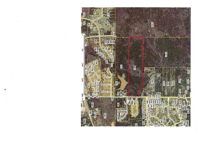
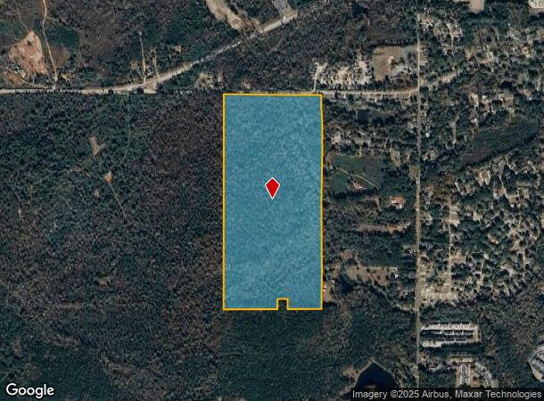
Property Record
1727 W Poplar St, Griffin, GA 30224
NEARBY LISTINGS FOR SALE OR LEASE
Property Detail
1727 W Poplar St
235-01-005
104.1 AC
Agriculturalland
Spalding
A
Georgia
13255C0180D
103.26 AC
2025
Spalding County
2025
Atlanta
160702
Atlanta-Sandy Springs-Roswell, GA
DEMOGRAPHICS near 1727 W Poplar St
1 Mile
3 Mile
5 Mile
2024 Total Population
3,577
19,520
47,911
2029 Population
3,763
20,672
51,063
Pop Growth 2024-2029
+ 5.20%
+ 5.90%
+ 6.58%
Average Age
36
38
38
2024 Total Households
1,293
7,259
17,994
HH Growth 2024-2029
+ 4.87%
+ 5.83%
+ 6.45%
Median Household Inc
$55,544
$50,838
$50,438
Avg Household Size
2.50
2.50
2.60
2024 Avg HH Vehicles
2.00
2.00
2.00
Median Home Value
$144,674
$174,841
$172,145
Median Year Built
1991
1984
1978
Nearby Places
Map Layers
Map Styles
 Street
 Aerial
- Restaurants
- Banks
- Shops
- Fitness
- Groceries
PUBLIC TRANSPORTATION
AIRPORT
Hartsfield - Jackson Atlanta International
DRIVE
WALK
Distance
Hartsfield - Jackson Atlanta International
54 min
32.7 mi
Freight Ports
Georgia Ports - Savannah
DRIVE
WALK
Distance
Georgia Ports - Savannah
254 min
221.2 mi
SALE & LEASE HISTORY
LISTING DATE
SALE/LEASE

Jul 19, 2017
For Sale
Nearby Properties
Address
Land Use
TOTAL SIZE
Lot Size
Zoning
Address
Land Use
TOTAL SIZE
Lot Size
Zoning
210,196 SF
14.92 AC
PCD
Address
Land Use
TOTAL SIZE
Lot Size
Zoning
112,554 SF
40.27 AC
C2
Address
Land Use
TOTAL SIZE
Lot Size
Zoning
46,074 SF
30.36 AC
OI
Address
Land Use
TOTAL SIZE
Lot Size
Zoning
56,415 SF
0.56 AC
PCD
Address
Land Use
TOTAL SIZE
Lot Size
Zoning
31,328 SF
58.43 AC
PID
Address
Land Use
TOTAL SIZE
Lot Size
Zoning
31,328 SF
58.43 AC
PID
Address
Land Use
TOTAL SIZE
Lot Size
Zoning
89,096 SF
22.41 AC
PCD
Address
Land Use
TOTAL SIZE
Lot Size
Zoning
133.41 AC
INST
Address
Land Use
TOTAL SIZE
Lot Size
Zoning
305,123 SF
37 AC
C2
Address
Land Use
TOTAL SIZE
Lot Size
Zoning
125,587 SF
11.87 AC
HDRA
Address
Land Use
TOTAL SIZE
Lot Size
Zoning
221,554 SF
23.89 AC
PCD
Address
Land Use
TOTAL SIZE
Lot Size
Zoning
89.45 AC
INST
Address
Land Use
TOTAL SIZE
Lot Size
Zoning
96,787 SF
13.42 AC
LDRB
Address
Land Use
TOTAL SIZE
Lot Size
Zoning
99,469 SF
12.51 AC
AR-1
Address
Land Use
TOTAL SIZE
Lot Size
Zoning
2,374 SF
38.28 AC
HDRB
Address
Land Use
TOTAL SIZE
Lot Size
Zoning
10,000 SF
11.82 AC
PCD
Address
Land Use
TOTAL SIZE
Lot Size
Zoning
52,636 SF
2.69 AC
PCD
Address
Land Use
TOTAL SIZE
Lot Size
Zoning
118,410 SF
15.42 AC
LDRB
Address
Land Use
TOTAL SIZE
Lot Size
Zoning
3,069 SF
15 AC
HDR-B
Address
Land Use
TOTAL SIZE
Lot Size
Zoning
55.08 AC
R-1
Address
Land Use
TOTAL SIZE
Lot Size
Zoning
3,716 SF
12.03 AC
PRD
Address
Land Use
TOTAL SIZE
Lot Size
Zoning
74,910 SF
25 AC
AR-1
Address
Land Use
TOTAL SIZE
Lot Size
Zoning
20,383 SF
2.93 AC
HDRA/PCD
Address
Land Use
TOTAL SIZE
Lot Size
Zoning
47,652 SF
2.59 AC
PCD
Address
Land Use
TOTAL SIZE
Lot Size
Zoning
74,412 SF
11.87 AC
HDRA
Address
Land Use
TOTAL SIZE
Lot Size
Zoning
57,929 SF
11.90 AC
Address
Land Use
TOTAL SIZE
Lot Size
Zoning
1,537 SF
7 AC
HDRA
Address
Land Use
TOTAL SIZE
Lot Size
Zoning
43,440 SF
23.20 AC
AR-1
Address
Land Use
TOTAL SIZE
Lot Size
Zoning
102,102 SF
10.84 AC
PCD
Address
Land Use
TOTAL SIZE
Lot Size
Zoning
65,058 SF
3.74 AC
The World's #1 Commercial Real Estate Marketplace
Connect with us
© 2026 CoStar Group
The information above has been obtained from sources believed reliable. While we do not doubt its accuracy we have not verified it and make no guarantee, warranty or representation about it. It is your responsibility to independently confirm its accuracy and completeness. Any projections, opinions, assumptions, or estimates used are for example only and do not represent the current or future performance of the property. The value of this transaction to you depends on tax and other factors which should be evaluated by your tax, financial, and legal advisors. You and your advisors should conduct a careful, independent investigation of the property to determine to your satisfaction the suitability of the property for your needs.