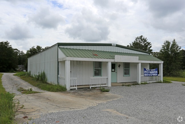
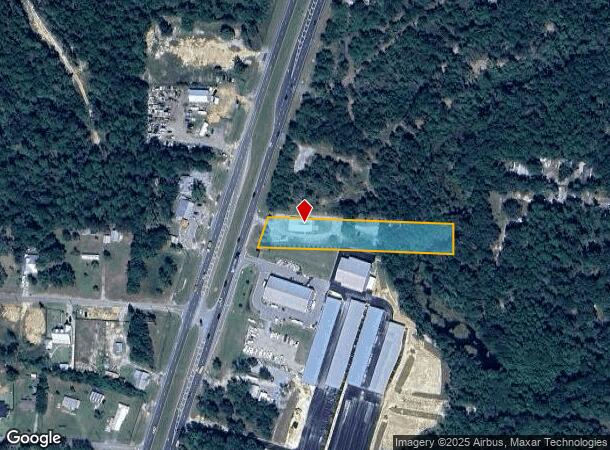
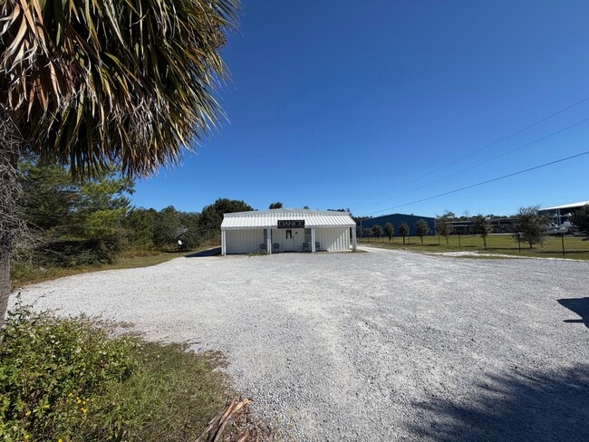
Property Record
17287 Us Highway 331 S, Freeport, FL 32439
Current Lease Availabilities
NEARBY LISTINGS FOR SALE OR LEASE
Property Detail
17287 Us Highway 331 S
Crestview-Fort Walton Beach-Destin, FL
Santa Rosa Plantation
22-1S-19-23000-018-0020
COM AT SE/C OF SEC 22-1S-19W, N 00 DEG 2613E 996.14FT TO POB; N 87 DEG 0617W 636.51FT TO PT ON ELY ROW LINE OF SAID US HWY 331 (120 FT ROW), N 18 DEG 0100E ALG SAID ELY ROW LINE 103.59FT, DPRT SAID ELY ROW LINE S 87 DEG 0617E 605.19FT TO PT ON E LINE
Storemultistory
Walton
A
Florida
12131C0557H
20
2025
1.40 AC
2025
Florida Panhandle Area
950501
Other Market Areas
4,668 SF
DEMOGRAPHICS near 17287 Us Highway 331 S
1 Mile
3 Mile
5 Mile
2024 Total Population
741
7,120
10,074
2029 Population
910
8,835
12,500
Pop Growth 2024-2029
+ 22.81%
+ 24.09%
+ 24.08%
Average Age
38
38
38
2024 Total Households
273
2,614
3,714
HH Growth 2024-2029
+ 23.08%
+ 24.41%
+ 24.37%
Median Household Inc
$59,999
$50,469
$50,026
Avg Household Size
2.60
2.60
2.60
2024 Avg HH Vehicles
2.00
2.00
2.00
Median Home Value
$289,285
$287,765
$283,189
Median Year Built
2001
2007
2007
Nearby Places
- Restaurants
- Banks
- Shops
- Fitness
- Groceries
PUBLIC TRANSPORTATION
AIRPORT
Eglin AFB/Destin-Ft Walton Beach
DRIVE
WALK
Distance
Eglin AFB/Destin-Ft Walton Beach
64 min
31.0 mi
Northwest Florida Beaches International
DRIVE
WALK
Distance
Northwest Florida Beaches International
43 min
31.6 mi
Freight Ports
Port of Panama City
DRIVE
WALK
Distance
Port of Panama City
59 min
40.1 mi
Nearby Properties
Address
Land Use
TOTAL SIZE
Lot Size
Zoning
Address
Land Use
TOTAL SIZE
Lot Size
Zoning
176,047 SF
29.75 AC
Address
Land Use
TOTAL SIZE
Lot Size
Zoning
469,205 SF
21.39 AC
BYLAGR
Address
Land Use
TOTAL SIZE
Lot Size
Zoning
334,804 SF
13.94 AC
MUNI
Address
Land Use
TOTAL SIZE
Lot Size
Zoning
311,974 SF
7.28 AC
Address
Land Use
TOTAL SIZE
Lot Size
Zoning
161,667 SF
26.97 AC
3310
Address
Land Use
TOTAL SIZE
Lot Size
Zoning
63,166 SF
9.06 AC
3310
Address
Land Use
TOTAL SIZE
Lot Size
Zoning
306.09 AC
3310
Address
Land Use
TOTAL SIZE
Lot Size
Zoning
87,549 SF
11 AC
Address
Land Use
TOTAL SIZE
Lot Size
Zoning
1,759 SF
0.63 AC
Address
Land Use
TOTAL SIZE
Lot Size
Zoning
88.24 AC
3310
Address
Land Use
TOTAL SIZE
Lot Size
Zoning
81,765 SF
5.51 AC
BYLAGR
Address
Land Use
TOTAL SIZE
Lot Size
Zoning
46,904 SF
93.38 AC
BYLAGR
Address
Land Use
TOTAL SIZE
Lot Size
Zoning
2,072 SF
23.08 AC
MUNI
Address
Land Use
TOTAL SIZE
Lot Size
Zoning
5,624 SF
1.35 AC
3310
Address
Land Use
TOTAL SIZE
Lot Size
Zoning
31,217 SF
5.45 AC
3310
Address
Land Use
TOTAL SIZE
Lot Size
Zoning
12,472 SF
10.63 AC
Address
Land Use
TOTAL SIZE
Lot Size
Zoning
51,885 SF
8.65 AC
3310
Address
Land Use
TOTAL SIZE
Lot Size
Zoning
16,297 SF
13.93 AC
Address
Land Use
TOTAL SIZE
Lot Size
Zoning
4,400 SF
6.04 AC
3310
Address
Land Use
TOTAL SIZE
Lot Size
Zoning
16,804 SF
2.07 AC
Address
Land Use
TOTAL SIZE
Lot Size
Zoning
12,290 SF
1.45 AC
Address
Land Use
TOTAL SIZE
Lot Size
Zoning
30,164 SF
2.23 AC
3310
Address
Land Use
TOTAL SIZE
Lot Size
Zoning
10.84 AC
MUNI
Address
Land Use
TOTAL SIZE
Lot Size
Zoning
12,080 SF
3.50 AC
3310
Address
Land Use
TOTAL SIZE
Lot Size
Zoning
924 SF
11.89 AC
3310
Address
Land Use
TOTAL SIZE
Lot Size
Zoning
17,730 SF
2.68 AC
Address
Land Use
TOTAL SIZE
Lot Size
Zoning
9,475 SF
8.45 AC
3310
Address
Land Use
TOTAL SIZE
Lot Size
Zoning
5,040 SF
36.94 AC
Address
Land Use
TOTAL SIZE
Lot Size
Zoning
38,148 SF
4.04 AC
3310
Address
Land Use
TOTAL SIZE
Lot Size
Zoning
59,516 SF
4.84 AC
MUNI
The World's #1 Commercial Real Estate Marketplace
Connect with us
© 2025 CoStar Group
The information above has been obtained from sources believed reliable. While we do not doubt its accuracy we have not verified it and make no guarantee, warranty or representation about it. It is your responsibility to independently confirm its accuracy and completeness. Any projections, opinions, assumptions, or estimates used are for example only and do not represent the current or future performance of the property. The value of this transaction to you depends on tax and other factors which should be evaluated by your tax, financial, and legal advisors. You and your advisors should conduct a careful, independent investigation of the property to determine to your satisfaction the suitability of the property for your needs.