Property Record
1729 Nc 42 Hwy, Willow Spring, NC 27592
NEARBY LISTINGS FOR SALE OR LEASE
Property Detail
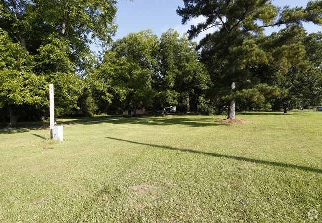
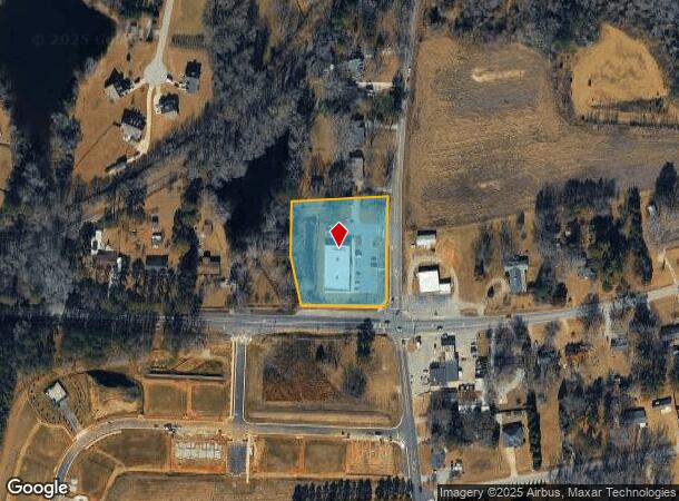
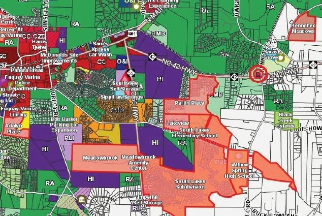
1729 Nc 42 Hwy
Raleigh/Durham
Rlb Holdings
Raleigh, NC
RLB HOLDINGS 21 LLC RCMB BM2021-01923
0677.04-90-3142-000
Wake
Commercialnec
North Carolina
2025
1
2025
1.87 AC
052901
Southeast Wake County
8,875 SF
DEMOGRAPHICS near 1729 Nc 42 Hwy
1 Mile
3 Mile
5 Mile
2024 Total Population
2,508
25,627
80,266
2029 Population
2,772
28,291
88,533
Pop Growth 2024-2029
+ 10.53%
+ 10.40%
+ 10.30%
Average Age
39
39
39
2024 Total Households
909
9,059
28,523
HH Growth 2024-2029
+ 10.56%
+ 10.42%
+ 10.31%
Median Household Inc
$92,968
$88,946
$89,890
Avg Household Size
2.70
2.80
2.80
2024 Avg HH Vehicles
2.00
2.00
2.00
Median Home Value
$371,401
$351,383
$349,307
Median Year Built
2007
2004
2003
Nearby Places
- Restaurants
- Banks
- Shops
- Fitness
- Groceries
PUBLIC TRANSPORTATION
AIRPORT
Raleigh-Durham International
DRIVE
WALK
Distance
Raleigh-Durham International
40 min
26.4 mi
Freight Ports
Port of Wilmington
DRIVE
WALK
Distance
Port of Wilmington
146 min
124.1 mi
SALE & LEASE HISTORY
LISTING DATE
SALE/LEASE

Aug 23, 2017
For Sale
Apr 12, 2019
For Sale
Nearby Properties
Address
Land Use
TOTAL SIZE
Lot Size
Zoning
Address
Land Use
TOTAL SIZE
Lot Size
Zoning
435,576 SF
29.37 AC
RHD-C
Address
Land Use
TOTAL SIZE
Lot Size
Zoning
207,800 SF
7.18 AC
NMU
Address
Land Use
TOTAL SIZE
Lot Size
Zoning
346,384 SF
56.12 AC
HI
Address
Land Use
TOTAL SIZE
Lot Size
Zoning
125,079 SF
15.15 AC
OI-CZ
Address
Land Use
TOTAL SIZE
Lot Size
Zoning
158,656 SF
10.31 AC
CC-CZ
Address
Land Use
TOTAL SIZE
Lot Size
Zoning
79,799 SF
25.53 AC
OI-CZ
Address
Land Use
TOTAL SIZE
Lot Size
Zoning
237,750 SF
41.18 AC
RLI
Address
Land Use
TOTAL SIZE
Lot Size
Zoning
290,054 SF
34.18 AC
HI
Address
Land Use
TOTAL SIZE
Lot Size
Zoning
83,208 SF
27.68 AC
O&I
Address
Land Use
TOTAL SIZE
Lot Size
Zoning
101,680 SF
2.36 AC
UMU
Address
Land Use
TOTAL SIZE
Lot Size
Zoning
83,283 SF
14.79 AC
GC
Address
Land Use
TOTAL SIZE
Lot Size
Zoning
99,307 SF
10.91 AC
CC
Address
Land Use
TOTAL SIZE
Lot Size
Zoning
79,212 SF
4.10 AC
CC-CZ
Address
Land Use
TOTAL SIZE
Lot Size
Zoning
30,043 SF
12.77 AC
GC
Address
Land Use
TOTAL SIZE
Lot Size
Zoning
112,700 SF
15.84 AC
HI
Address
Land Use
TOTAL SIZE
Lot Size
Zoning
149,975 SF
18.73 AC
GC
Address
Land Use
TOTAL SIZE
Lot Size
Zoning
73,410 SF
21.97 AC
O&I
Address
Land Use
TOTAL SIZE
Lot Size
Zoning
183,855 SF
19.67 AC
HI
Address
Land Use
TOTAL SIZE
Lot Size
Zoning
69,135 SF
13.58 AC
RA
Address
Land Use
TOTAL SIZE
Lot Size
Zoning
130,000 SF
8 AC
CC-CZ
Address
Land Use
TOTAL SIZE
Lot Size
Zoning
56,940 SF
7.20 AC
GC
Address
Land Use
TOTAL SIZE
Lot Size
Zoning
107,689 SF
10.18 AC
CC
Address
Land Use
TOTAL SIZE
Lot Size
Zoning
85,396 SF
4.98 AC
RLI-C
Address
Land Use
TOTAL SIZE
Lot Size
Zoning
140,592 SF
10.04 AC
RLI
Address
Land Use
TOTAL SIZE
Lot Size
Zoning
1,120 SF
224.11 AC
RA
Address
Land Use
TOTAL SIZE
Lot Size
Zoning
48,333 SF
5.69 AC
CC
Address
Land Use
TOTAL SIZE
Lot Size
Zoning
67,473 SF
5.16 AC
RHD
Address
Land Use
TOTAL SIZE
Lot Size
Zoning
41.53 AC
CMU
Address
Land Use
TOTAL SIZE
Lot Size
Zoning
86,111 SF
6.61 AC
CC
Address
Land Use
TOTAL SIZE
Lot Size
Zoning
97,059 SF
12.67 AC
GC
The World's #1 Commercial Real Estate Marketplace
Connect with us
© 2025 CoStar Group
The information above has been obtained from sources believed reliable. While we do not doubt its accuracy we have not verified it and make no guarantee, warranty or representation about it. It is your responsibility to independently confirm its accuracy and completeness. Any projections, opinions, assumptions, or estimates used are for example only and do not represent the current or future performance of the property. The value of this transaction to you depends on tax and other factors which should be evaluated by your tax, financial, and legal advisors. You and your advisors should conduct a careful, independent investigation of the property to determine to your satisfaction the suitability of the property for your needs.