Property Record
1729 Oceanside Blvd, Oceanside, CA 92054
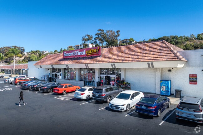

Property Detail
1729 Oceanside Blvd
151-310-26
TCT 101 0.51 AC M/L IN PAR 3 PER R&T MAP 326 IN TR 000622
Regionalshoppingcenterormallwithanchorstore
SAN DIEGO
CS-HO
California
AE The base floodplain where base flood elevations are provided. AE Zones are now used on new format FIRMs instead of A1-A30 Zones.
101
2025
3.37 AC
2025
Oceanside
018509
San Diego
23,384 SF
San Diego-Chula Vista-Carlsbad, CA
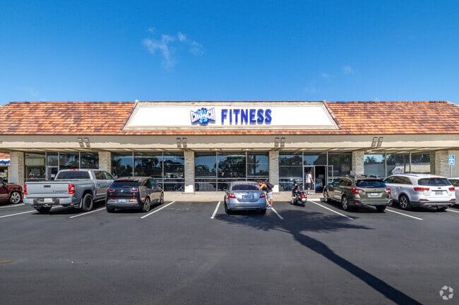
NEARBY LISTINGS FOR SALE OR LEASE
DEMOGRAPHICS near 1729 Oceanside Blvd
1 mile
3 mile
5 mile
2025 Total Population
19,302
95,900
196,018
2030 Population
19,505
97,499
197,999
Pop Growth 2025-2030
+ 1.05%
+ 1.67%
+ 1.01%
Average Age
40
39
39
2025 Total Households
7,554
36,724
70,757
HH Growth 2025-2030
+ 1.09%
+ 1.95%
+ 1.16%
Median Household Inc
$86,010
$86,790
$94,241
Avg Household Size
2.50
2.40
2.60
2025 Avg HH Vehicles
2.00
2.00
2.00
Median Home Value
$952,735
$891,775
$825,318
Median Year Built
1972
1978
1983
Nearby Places
Map Layers
Map Styles
 Street
 Aerial
Layers
 Traffic
 Biking
Places
Listings with unknown addresses are not visible on the map
- Restaurants
- Banks
- Shops
- Fitness
- Groceries
PUBLIC TRANSPORTATION
TRANSIT/SUBWAY
Crouch Street (Sprinter - San Diego North County Transit District (Coaster/Sprinter/Breeze))
Drive
Walk
Distance
Crouch Street (Sprinter - San Diego North County Transit District (Coaster/Sprinter/Breeze))
3 min
12 min
0.6 mi
COMMUTER RAIL
Oceanside Transit Center (Orange County Line - Southern California Regional Rail Authority (Metrolink))
Drive
Walk
Distance
Oceanside Transit Center (Orange County Line - Southern California Regional Rail Authority (Metrolink))
7 min
2.2 mi
Carlsbad Village (Coaster - San Diego North County Transit District (Coaster/Sprinter/Breeze))
Drive
Walk
Distance
Carlsbad Village (Coaster - San Diego North County Transit District (Coaster/Sprinter/Breeze))
8 min
3.3 mi
AIRPORT
San Diego International
Drive
Walk
Distance
San Diego International
46 min
35.4 mi
Freight Ports
Port of San Diego
Drive
Walk
Distance
Port of San Diego
51 min
39.7 mi
SALE & LEASE HISTORY
LISTING DATE
SALE/LEASE

Sep 25, 2016
For Lease
Mar 23, 2018
For Lease
Mar 19, 2018
For Lease
Jan 25, 2017
For Lease
Feb 07, 2023
For Sale
Nearby Properties
Address
Land Use
TOTAL SIZE
Lot Size
Zoning
Address
Land Use
TOTAL SIZE
Lot Size
Zoning
1.38 AC
C
Address
Land Use
TOTAL SIZE
Lot Size
Zoning
9,999 SF
5.28 AC
C2
Address
Land Use
TOTAL SIZE
Lot Size
Zoning
16 AC
P-C
Address
Land Use
TOTAL SIZE
Lot Size
Zoning
1.38 AC
C
Address
Land Use
TOTAL SIZE
Lot Size
Zoning
12 AC
SP-1-09
Address
Land Use
TOTAL SIZE
Lot Size
Zoning
4.26 AC
C-2
Address
Land Use
TOTAL SIZE
Lot Size
Zoning
1.77 AC
C-2
Address
Land Use
TOTAL SIZE
Lot Size
Zoning
1.14 AC
C
Address
Land Use
TOTAL SIZE
Lot Size
Zoning
96,240 SF
22.25 AC
PD-2
Address
Land Use
TOTAL SIZE
Lot Size
Zoning
85,000 SF
4.40 AC
CC
Address
Land Use
TOTAL SIZE
Lot Size
Zoning
5.24 AC
SP-1-09
Address
Land Use
TOTAL SIZE
Lot Size
Zoning
19.51 AC
C-2-Q
Address
Land Use
TOTAL SIZE
Lot Size
Zoning
10.63 AC
RD-M
Address
Land Use
TOTAL SIZE
Lot Size
Zoning
1.02 AC
D-1
Address
Land Use
TOTAL SIZE
Lot Size
Zoning
2.30 AC
V-R
Address
Land Use
TOTAL SIZE
Lot Size
Zoning
4.68 AC
D-6B
Address
Land Use
TOTAL SIZE
Lot Size
Zoning
6.63 AC
RD-M
Address
Land Use
TOTAL SIZE
Lot Size
Zoning
57,905 SF
2.16 AC
R-3
Address
Land Use
TOTAL SIZE
Lot Size
Zoning
1.34 AC
V-B
Address
Land Use
TOTAL SIZE
Lot Size
Zoning
64,722 SF
2.17 AC
D-1
Address
Land Use
TOTAL SIZE
Lot Size
Zoning
6,024 SF
6.92 AC
VC
Address
Land Use
TOTAL SIZE
Lot Size
Zoning
92,481 SF
9.53 AC
CG-PBD
Address
Land Use
TOTAL SIZE
Lot Size
Zoning
9.59 AC
RD-M-Q
Address
Land Use
TOTAL SIZE
Lot Size
Zoning
59,587 SF
0.69 AC
V-R
Address
Land Use
TOTAL SIZE
Lot Size
Zoning
8,630 SF
1.30 AC
C-2
Address
Land Use
TOTAL SIZE
Lot Size
Zoning
96,942 SF
4.49 AC
R-3
Address
Land Use
TOTAL SIZE
Lot Size
Zoning
15.53 AC
SP-1-09 (R
Address
Land Use
TOTAL SIZE
Lot Size
Zoning
66,816 SF
9.55 AC
RH
Address
Land Use
TOTAL SIZE
Lot Size
Zoning
9.52 AC
CS-HO
Address
Land Use
TOTAL SIZE
Lot Size
Zoning
10.15 AC
P-C
The World's #1 Commercial Real Estate Marketplace
Connect with us
© 2026 CoStar Group
The information above has been obtained from sources believed reliable. While we do not doubt its accuracy we have not verified it and make no guarantee, warranty or representation about it. It is your responsibility to independently confirm its accuracy and completeness. Any projections, opinions, assumptions, or estimates used are for example only and do not represent the current or future performance of the property. The value of this transaction to you depends on tax and other factors which should be evaluated by your tax, financial, and legal advisors. You and your advisors should conduct a careful, independent investigation of the property to determine to your satisfaction the suitability of the property for your needs.