No Photo
Property Record
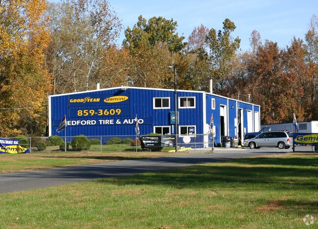
1729 Route 70, Southampton, NJ 08088

Property Detail
1729 Route 70
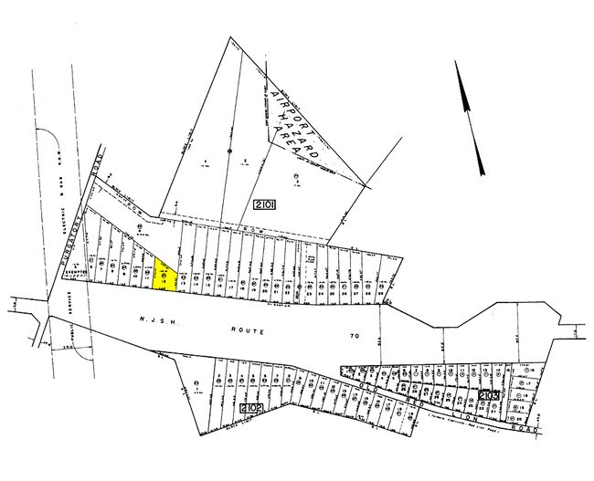
33-02101-0000-00012
Burlington
Autorepair
New Jersey
HC
12
A Areas with a 1% annual chance of flooding and a 26% chance of flooding over the life of a 30-year mortgage.
0.84 AC
2024
South Burlington County
2025
Philadelphia
703202
Philadelphia-Camden-Wilmington, PA-NJ-DE-MD
NEARBY LISTINGS FOR SALE OR LEASE
DEMOGRAPHICS near 1729 Route 70
1 mile
3 mile
5 mile
2025 Total Population
219
11,449
43,091
2030 Population
223
11,801
44,339
Pop Growth 2025-2030
+ 1.83%
+ 3.07%
+ 2.90%
Average Age
42
46
45
2025 Total Households
74
4,478
16,616
HH Growth 2025-2030
+ 1.35%
+ 3.24%
+ 3.02%
Median Household Inc
$164,285
$118,452
$126,814
Avg Household Size
2.90
2.50
2.60
2025 Avg HH Vehicles
3.00
2.00
2.00
Median Home Value
$600,000
$426,904
$445,827
Median Year Built
1980
1978
1977
Nearby Places
Map Layers
Map Styles
 Street
 Aerial
Layers
 Traffic
 Biking
Places
Listings with unknown addresses are not visible on the map
- Restaurants
- Banks
- Shops
- Fitness
- Groceries
PUBLIC TRANSPORTATION
AIRPORT
Philadelphia International
Drive
Walk
Distance
Philadelphia International
45 min
32.0 mi
Trenton Mercer
Drive
Walk
Distance
Trenton Mercer
46 min
33.2 mi
Freight Ports
Port of Philadelphia
Drive
Walk
Distance
Port of Philadelphia
30 min
22.1 mi
Nearby Properties
Address
Land Use
TOTAL SIZE
Lot Size
Zoning
Address
Land Use
TOTAL SIZE
Lot Size
Zoning
103.84 AC
PPE
Address
Land Use
TOTAL SIZE
Lot Size
Zoning
62.20 AC
GMN
Address
Land Use
TOTAL SIZE
Lot Size
Zoning
49.38 AC
PPE
Address
Land Use
TOTAL SIZE
Lot Size
Zoning
75,619 SF
57.38 AC
PPE
Address
Land Use
TOTAL SIZE
Lot Size
Zoning
23.70 AC
HM
Address
Land Use
TOTAL SIZE
Lot Size
Zoning
67,508 SF
18.55 AC
LI
Address
Land Use
TOTAL SIZE
Lot Size
Zoning
157.02 AC
VRD
Address
Land Use
TOTAL SIZE
Lot Size
Zoning
20,460 SF
23.95 AC
AR
Address
Land Use
TOTAL SIZE
Lot Size
Zoning
1.64 AC
SGRA
Address
Land Use
TOTAL SIZE
Lot Size
Zoning
42,060 SF
15.49 AC
CC
Address
Land Use
TOTAL SIZE
Lot Size
Zoning
83,228 SF
17 AC
HC-2
Address
Land Use
TOTAL SIZE
Lot Size
Zoning
40.08 AC
Address
Land Use
TOTAL SIZE
Lot Size
Zoning
18,184 SF
3.50 AC
CC
Address
Land Use
TOTAL SIZE
Lot Size
Zoning
26,203 SF
3.06 AC
CC
Address
Land Use
TOTAL SIZE
Lot Size
Zoning
12,151 SF
2.17 AC
CC
Address
Land Use
TOTAL SIZE
Lot Size
Zoning
1,750 SF
7.91 AC
I
Address
Land Use
TOTAL SIZE
Lot Size
Zoning
8,334 SF
1.42 AC
CC
Address
Land Use
TOTAL SIZE
Lot Size
Zoning
5,522 SF
5.14 AC
HM
Address
Land Use
TOTAL SIZE
Lot Size
Zoning
13,316 SF
2.20 AC
CC
Address
Land Use
TOTAL SIZE
Lot Size
Zoning
8.30 AC
GMN
Address
Land Use
TOTAL SIZE
Lot Size
Zoning
75,000 SF
3.96 AC
HC-2
Address
Land Use
TOTAL SIZE
Lot Size
Zoning
5.63 AC
HC
Address
Land Use
TOTAL SIZE
Lot Size
Zoning
15.20 AC
Address
Land Use
TOTAL SIZE
Lot Size
Zoning
21,420 SF
5.23 AC
CC
Address
Land Use
TOTAL SIZE
Lot Size
Zoning
12,768 SF
1.69 AC
LC
Address
Land Use
TOTAL SIZE
Lot Size
Zoning
13,650 SF
1.74 AC
CC
Address
Land Use
TOTAL SIZE
Lot Size
Zoning
1,404 SF
16.50 AC
PPE
Address
Land Use
TOTAL SIZE
Lot Size
Zoning
8.38 AC
HC
Address
Land Use
TOTAL SIZE
Lot Size
Zoning
10,998 SF
1 AC
RS-2
Address
Land Use
TOTAL SIZE
Lot Size
Zoning
14,132 SF
74.21 AC
LSR
The World's #1 Commercial Real Estate Marketplace
Connect with us
© 2026 CoStar Group
The information above has been obtained from sources believed reliable. While we do not doubt its accuracy we have not verified it and make no guarantee, warranty or representation about it. It is your responsibility to independently confirm its accuracy and completeness. Any projections, opinions, assumptions, or estimates used are for example only and do not represent the current or future performance of the property. The value of this transaction to you depends on tax and other factors which should be evaluated by your tax, financial, and legal advisors. You and your advisors should conduct a careful, independent investigation of the property to determine to your satisfaction the suitability of the property for your needs.