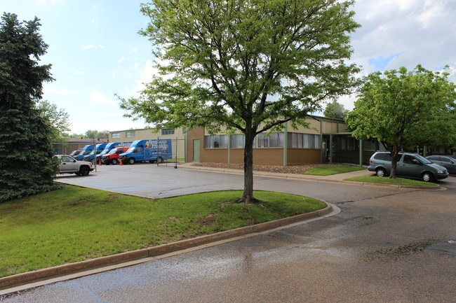
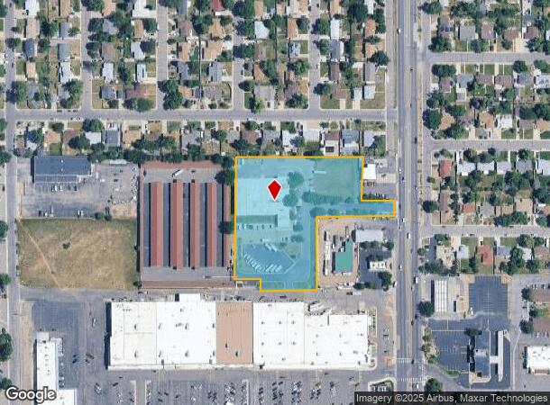
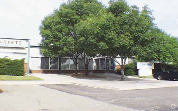
Property Record
1729 S Wadsworth Blvd, Lakewood, CO 80232

Current Lease Availabilities
NEARBY LISTINGS FOR SALE OR LEASE
Property Detail
1729 S Wadsworth Blvd
Denver-Aurora-Centennial, CO
Williamsburg Business Center Flg # 1
49-233-17-020
SECTION 23 TOWNSHIP 04 RANGE 69 QTR SW SUBDIVISIONCD 837400 SUBDIVISIONNAME WILLIAMSBURG BUSINESS CENTER FLG # 1 BLOCK 001 LOT 0002 SIZE: 155250 TRACT VALUE: 3.564 SECTION 23 TOWNSHIP 04 RANGE 69 QTR SW SUBDIVISIONCD 837400 SUBDIVISIONNAME WILLIAMSBU
Industrialgeneral
Jefferson
X
Colorado
08059C0312G
1,2,
2023
3.57 AC
2024
Lakewood
011702
Denver
23,673 SF
DEMOGRAPHICS near 1729 S Wadsworth Blvd
1 Mile
3 Mile
5 Mile
2024 Total Population
14,920
135,051
330,847
2029 Population
14,692
133,780
329,932
Pop Growth 2024-2029
(1.53%)
(0.94%)
(0.28%)
Average Age
43
40
39
2024 Total Households
5,992
52,977
132,230
HH Growth 2024-2029
(1.64%)
(1.06%)
(0.30%)
Median Household Inc
$88,127
$75,010
$74,154
Avg Household Size
2.40
2.40
2.40
2024 Avg HH Vehicles
2.00
2.00
2.00
Median Home Value
$472,827
$456,259
$465,072
Median Year Built
1969
1971
1973
Nearby Places
Map Layers
Map Styles
 Street
 Aerial
- Restaurants
- Banks
- Shops
- Fitness
- Groceries
PUBLIC TRANSPORTATION
COMMUTER RAIL
Union Station: Lodo-Coors Field-16Th Street Mall (C Line - Denver Regional Transportation District Light Rail (TheRide), E Line - Denver Regional Transportation District Light Rail (TheRide), W Line - Denver Regional Transportation District Light Rail (TheRide))
DRIVE
WALK
Distance
Union Station: Lodo-Coors Field-16Th Street Mall (C Line - Denver Regional Transportation District Light Rail (TheRide), E Line - Denver Regional Transportation District Light Rail (TheRide), W Line - Denver Regional Transportation District Light Rail (TheRide))
15 min
8.8 mi
Denver (California Zephyr - Amtrak)
DRIVE
WALK
Distance
Denver (California Zephyr - Amtrak)
16 min
9.0 mi
AIRPORT
Denver International
DRIVE
WALK
Distance
Denver International
45 min
33.1 mi
Freight Ports
Tulsa Port Of Catoosa
DRIVE
WALK
Distance
Tulsa Port Of Catoosa
742 min
718.6 mi
Nearby Properties
Address
Land Use
TOTAL SIZE
Lot Size
Zoning
Address
Land Use
TOTAL SIZE
Lot Size
Zoning
3,195,026 SF
562.97 AC
Address
Land Use
TOTAL SIZE
Lot Size
Zoning
255,381 SF
16.52 AC
Address
Land Use
TOTAL SIZE
Lot Size
Zoning
298,752 SF
73.96 AC
Address
Land Use
TOTAL SIZE
Lot Size
Zoning
304,560 SF
23.94 AC
S-SU-F
Address
Land Use
TOTAL SIZE
Lot Size
Zoning
233,688 SF
22.37 AC
Address
Land Use
TOTAL SIZE
Lot Size
Zoning
199,685 SF
27.73 AC
Address
Land Use
TOTAL SIZE
Lot Size
Zoning
238,452 SF
8.03 AC
Address
Land Use
TOTAL SIZE
Lot Size
Zoning
446,582 SF
19.24 AC
Address
Land Use
TOTAL SIZE
Lot Size
Zoning
63,347 SF
20.70 AC
Address
Land Use
TOTAL SIZE
Lot Size
Zoning
135,372 SF
11.66 AC
Address
Land Use
TOTAL SIZE
Lot Size
Zoning
258,980 SF
16.55 AC
PUD
Address
Land Use
TOTAL SIZE
Lot Size
Zoning
82,756 SF
14.95 AC
Address
Land Use
TOTAL SIZE
Lot Size
Zoning
123,224 SF
8.74 AC
Address
Land Use
TOTAL SIZE
Lot Size
Zoning
224,595 SF
14.66 AC
Address
Land Use
TOTAL SIZE
Lot Size
Zoning
205,949 SF
16.46 AC
S-SU-F
Address
Land Use
TOTAL SIZE
Lot Size
Zoning
319,365 SF
11.60 AC
Address
Land Use
TOTAL SIZE
Lot Size
Zoning
146,133 SF
3.75 AC
Address
Land Use
TOTAL SIZE
Lot Size
Zoning
85,580 SF
12.54 AC
Address
Land Use
TOTAL SIZE
Lot Size
Zoning
220,656 SF
16.18 AC
Address
Land Use
TOTAL SIZE
Lot Size
Zoning
80,616 SF
2.21 AC
Address
Land Use
TOTAL SIZE
Lot Size
Zoning
80,798 SF
12.27 AC
PD
Address
Land Use
TOTAL SIZE
Lot Size
Zoning
91,402 SF
7.57 AC
B-3
Address
Land Use
TOTAL SIZE
Lot Size
Zoning
218,158 SF
20.16 AC
A2
Address
Land Use
TOTAL SIZE
Lot Size
Zoning
141,552 SF
11.16 AC
Address
Land Use
TOTAL SIZE
Lot Size
Zoning
157,469 SF
13.02 AC
S-SU-D
Address
Land Use
TOTAL SIZE
Lot Size
Zoning
68,758 SF
8.15 AC
E-SU-D1X
Address
Land Use
TOTAL SIZE
Lot Size
Zoning
101,208 SF
8.08 AC
Address
Land Use
TOTAL SIZE
Lot Size
Zoning
197,686 SF
1.46 AC
Address
Land Use
TOTAL SIZE
Lot Size
Zoning
52,493 SF
12.69 AC
Address
Land Use
TOTAL SIZE
Lot Size
Zoning
260,591 SF
11.59 AC
The World's #1 Commercial Real Estate Marketplace
Connect with us
© 2026 CoStar Group
The information above has been obtained from sources believed reliable. While we do not doubt its accuracy we have not verified it and make no guarantee, warranty or representation about it. It is your responsibility to independently confirm its accuracy and completeness. Any projections, opinions, assumptions, or estimates used are for example only and do not represent the current or future performance of the property. The value of this transaction to you depends on tax and other factors which should be evaluated by your tax, financial, and legal advisors. You and your advisors should conduct a careful, independent investigation of the property to determine to your satisfaction the suitability of the property for your needs.