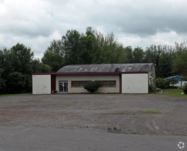
Property Record
173 County Route 57, Phoenix, NY 13135

NEARBY LISTINGS FOR SALE OR LEASE
Property Detail
173 County Route 57
Syracuse
Lahommedieu Location
Syracuse, NY
Oswego
355489-314-003-0001-017-000-0000
New York
Commercialacreage
0.96 AC
X
Oswego County
36067C0058F
DEMOGRAPHICS near 173 County Route 57
1 Mile
3 Mile
5 Mile
2024 Total Population
1,309
15,444
43,628
2029 Population
1,295
15,161
42,653
Pop Growth 2024-2029
(1.07%)
(1.83%)
(2.23%)
Average Age
45
43
42
2024 Total Households
524
6,740
17,732
HH Growth 2024-2029
(1.15%)
(2.00%)
(2.39%)
Median Household Inc
$90,555
$76,407
$83,178
Avg Household Size
2.40
2.20
2.40
2024 Avg HH Vehicles
2.00
2.00
2.00
Median Home Value
$231,600
$214,082
$199,014
Median Year Built
1981
1985
1983
Nearby Places
- Restaurants
- Banks
- Shops
- Fitness
- Groceries
PUBLIC TRANSPORTATION
AIRPORT
Syracuse Hancock International
DRIVE
WALK
Distance
Syracuse Hancock International
21 min
14.9 mi
Freight Ports
Albany, NY Port
DRIVE
WALK
Distance
Albany, NY Port
184 min
155.0 mi
Nearby Properties
Address
Land Use
TOTAL SIZE
Lot Size
Zoning
Address
Land Use
TOTAL SIZE
Lot Size
Zoning
442,970 SF
33.63 AC
PUD
Address
Land Use
TOTAL SIZE
Lot Size
Zoning
247,864 SF
39.34 AC
PUD
Address
Land Use
TOTAL SIZE
Lot Size
Zoning
107,336 SF
28.62 AC
PUD
Address
Land Use
TOTAL SIZE
Lot Size
Zoning
126,699 SF
15.40 AC
R-1
Address
Land Use
TOTAL SIZE
Lot Size
Zoning
4,066 SF
34.38 AC
R-1
Address
Land Use
TOTAL SIZE
Lot Size
Zoning
169,829 SF
15.46 AC
PUD
Address
Land Use
TOTAL SIZE
Lot Size
Zoning
108,066 SF
25.57 AC
R-1
Address
Land Use
TOTAL SIZE
Lot Size
Zoning
94,738 SF
32.90 AC
R-1
Address
Land Use
TOTAL SIZE
Lot Size
Zoning
5,400 SF
6.47 AC
PUD
Address
Land Use
TOTAL SIZE
Lot Size
Zoning
6,983 SF
9.21 AC
PUD
Address
Land Use
TOTAL SIZE
Lot Size
Zoning
2,520 SF
16.28 AC
FED
Address
Land Use
TOTAL SIZE
Lot Size
Zoning
6.98 AC
R-2
Address
Land Use
TOTAL SIZE
Lot Size
Zoning
34,535 SF
5 AC
PUD
Address
Land Use
TOTAL SIZE
Lot Size
Zoning
9,198 SF
6.59 AC
PUD
Address
Land Use
TOTAL SIZE
Lot Size
Zoning
219.80 AC
PUD
Address
Land Use
TOTAL SIZE
Lot Size
Zoning
6,724 SF
10.05 AC
PUD
Address
Land Use
TOTAL SIZE
Lot Size
Zoning
17,628 SF
2.76 AC
PUD
Address
Land Use
TOTAL SIZE
Lot Size
Zoning
5,371 SF
154.56 AC
PUD
Address
Land Use
TOTAL SIZE
Lot Size
Zoning
3,600 SF
1.19 AC
IND
Address
Land Use
TOTAL SIZE
Lot Size
Zoning
4,483 SF
0.74 AC
B
Address
Land Use
TOTAL SIZE
Lot Size
Zoning
65,320 SF
12.97 AC
C-1
Address
Land Use
TOTAL SIZE
Lot Size
Zoning
20,000 SF
4.35 AC
I
Address
Land Use
TOTAL SIZE
Lot Size
Zoning
40,634 SF
3.80 AC
PUD
Address
Land Use
TOTAL SIZE
Lot Size
Zoning
30,000 SF
34.12 AC
R-2
Address
Land Use
TOTAL SIZE
Lot Size
Zoning
79.90 AC
PUD
Address
Land Use
TOTAL SIZE
Lot Size
Zoning
12,636 SF
1.58 AC
PUD
Address
Land Use
TOTAL SIZE
Lot Size
Zoning
1,044.15 AC
OSP
Address
Land Use
TOTAL SIZE
Lot Size
Zoning
9,350 SF
4.97 AC
PUD
Address
Land Use
TOTAL SIZE
Lot Size
Zoning
6,880 SF
2.03 AC
C-1
Address
Land Use
TOTAL SIZE
Lot Size
Zoning
1.32 AC
R-2
The World's #1 Commercial Real Estate Marketplace
Connect with us
© 2025 CoStar Group
The information above has been obtained from sources believed reliable. While we do not doubt its accuracy we have not verified it and make no guarantee, warranty or representation about it. It is your responsibility to independently confirm its accuracy and completeness. Any projections, opinions, assumptions, or estimates used are for example only and do not represent the current or future performance of the property. The value of this transaction to you depends on tax and other factors which should be evaluated by your tax, financial, and legal advisors. You and your advisors should conduct a careful, independent investigation of the property to determine to your satisfaction the suitability of the property for your needs.