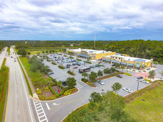
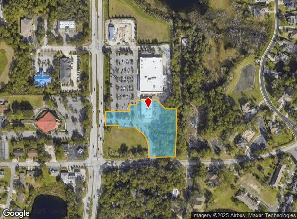
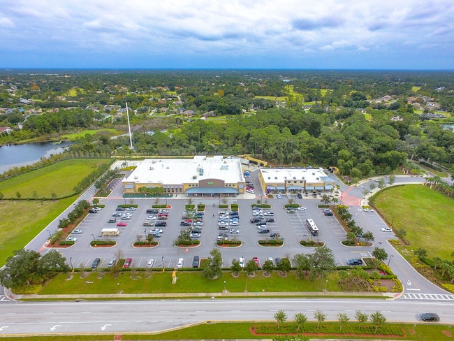
Property Record
173 N Charles Richard Beall Blvd, Debary, FL 32713
NEARBY LISTINGS FOR SALE OR LEASE
Property Detail
173 N Charles Richard Beall Blvd
Deltona-Daytona Beach-Ormond Beach, FL
Shoppes At Pine Meadow Mb
8027-15-00-0020
27-18-30 LOT 2 SHOPPES AT PINE MEADOW MB 57 PGS 28-31 INC PER OR 7634 PG 1221
Regionalshoppingcenterormallwithanchorstore
Volusia
X
Florida
12127C0620K
2
2025
2.70 AC
2025
Deltona
090905
Deltona/Daytona Beach
12,166 SF
DEMOGRAPHICS near 173 N Charles Richard Beall Blvd
1 Mile
3 Mile
5 Mile
2024 Total Population
7,719
39,180
89,591
2029 Population
8,422
43,270
98,685
Pop Growth 2024-2029
+ 9.11%
+ 10.44%
+ 10.15%
Average Age
47
43
42
2024 Total Households
3,187
15,560
34,643
HH Growth 2024-2029
+ 9.16%
+ 10.56%
+ 10.25%
Median Household Inc
$77,628
$61,655
$64,408
Avg Household Size
2.40
2.50
2.50
2024 Avg HH Vehicles
2.00
2.00
2.00
Median Home Value
$270,067
$241,713
$228,109
Median Year Built
1993
1990
1987
Nearby Places
Map Layers
Map Styles
 Street
 Aerial
- Restaurants
- Banks
- Shops
- Fitness
- Groceries
PUBLIC TRANSPORTATION
AIRPORT
Orlando Sanford International
DRIVE
WALK
Distance
Orlando Sanford International
27 min
14.1 mi
Daytona Beach International
DRIVE
WALK
Distance
Daytona Beach International
37 min
27.7 mi
Orlando International
DRIVE
WALK
Distance
Orlando International
56 min
42.3 mi
SALE & LEASE HISTORY
LISTING DATE
SALE/LEASE

Jan 17, 2024
For Lease
Dec 23, 2019
For Lease
Nearby Properties
Address
Land Use
TOTAL SIZE
Lot Size
Zoning
Address
Land Use
TOTAL SIZE
Lot Size
Zoning
485,392 SF
69.83 AC
ROW
Address
Land Use
TOTAL SIZE
Lot Size
Zoning
381,678 SF
15.85 AC
Address
Land Use
TOTAL SIZE
Lot Size
Zoning
409,021 SF
38.53 AC
ROW
Address
Land Use
TOTAL SIZE
Lot Size
Zoning
369,949 SF
13.70 AC
Address
Land Use
TOTAL SIZE
Lot Size
Zoning
258,869 SF
38.34 AC
P
Address
Land Use
TOTAL SIZE
Lot Size
Zoning
299,423 SF
88.63 AC
12R1
Address
Land Use
TOTAL SIZE
Lot Size
Zoning
350,763 SF
60 AC
12R1
Address
Land Use
TOTAL SIZE
Lot Size
Zoning
232,605 SF
15.03 AC
12B4
Address
Land Use
TOTAL SIZE
Lot Size
Zoning
9,460 SF
208.56 AC
Address
Land Use
TOTAL SIZE
Lot Size
Zoning
136,761 SF
17.77 AC
Address
Land Use
TOTAL SIZE
Lot Size
Zoning
121,380 SF
2.33 AC
Address
Land Use
TOTAL SIZE
Lot Size
Zoning
50,005 SF
5.60 AC
Address
Land Use
TOTAL SIZE
Lot Size
Zoning
170,850 SF
17.82 AC
Address
Land Use
TOTAL SIZE
Lot Size
Zoning
229,109 SF
11.54 AC
Address
Land Use
TOTAL SIZE
Lot Size
Zoning
11,016 SF
13 AC
01MH1
Address
Land Use
TOTAL SIZE
Lot Size
Zoning
213,506 SF
21 AC
12R2
Address
Land Use
TOTAL SIZE
Lot Size
Zoning
193,964 SF
23.50 AC
Address
Land Use
TOTAL SIZE
Lot Size
Zoning
135,845 SF
18.34 AC
Address
Land Use
TOTAL SIZE
Lot Size
Zoning
117,406 SF
17.58 AC
Address
Land Use
TOTAL SIZE
Lot Size
Zoning
169,634 SF
12.97 AC
01B
Address
Land Use
TOTAL SIZE
Lot Size
Zoning
11,509 SF
10 AC
01MH1
Address
Land Use
TOTAL SIZE
Lot Size
Zoning
147,759 SF
19.64 AC
Address
Land Use
TOTAL SIZE
Lot Size
Zoning
214,666 SF
9 AC
Address
Land Use
TOTAL SIZE
Lot Size
Zoning
174,640 SF
13.46 AC
Address
Land Use
TOTAL SIZE
Lot Size
Zoning
44,975 SF
7.98 AC
Address
Land Use
TOTAL SIZE
Lot Size
Zoning
115,271 SF
17.08 AC
R4
Address
Land Use
TOTAL SIZE
Lot Size
Zoning
127,891 SF
10.58 AC
Address
Land Use
TOTAL SIZE
Lot Size
Zoning
87,981 SF
4.43 AC
Address
Land Use
TOTAL SIZE
Lot Size
Zoning
109,060 SF
13.21 AC
ROW
Address
Land Use
TOTAL SIZE
Lot Size
Zoning
130,665 SF
9.20 AC
01B9
The World's #1 Commercial Real Estate Marketplace
Connect with us
© 2025 CoStar Group
The information above has been obtained from sources believed reliable. While we do not doubt its accuracy we have not verified it and make no guarantee, warranty or representation about it. It is your responsibility to independently confirm its accuracy and completeness. Any projections, opinions, assumptions, or estimates used are for example only and do not represent the current or future performance of the property. The value of this transaction to you depends on tax and other factors which should be evaluated by your tax, financial, and legal advisors. You and your advisors should conduct a careful, independent investigation of the property to determine to your satisfaction the suitability of the property for your needs.