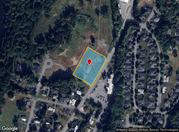
Property Record
River Park Dr, Lebanon, NH 03766

NEARBY LISTINGS FOR SALE OR LEASE
Property Detail
River Park Dr
LBAN M:44 B:21 L:
Grafton
Residentialacreage
New Hampshire
X
1.47 AC
33009C0893E
Concord/New Hampshire North Area
2024
Other Market Areas
2024
Claremont-Lebanon, NH-VT
961802
DEMOGRAPHICS near River Park Dr
1 Mile
3 Mile
5 Mile
2024 Total Population
4,434
16,393
32,327
2029 Population
4,553
16,983
33,475
Pop Growth 2024-2029
+ 2.68%
+ 3.60%
+ 3.55%
Average Age
43
42
41
2024 Total Households
2,112
7,823
13,623
HH Growth 2024-2029
+ 2.56%
+ 3.52%
+ 3.71%
Median Household Inc
$69,753
$77,155
$89,070
Avg Household Size
2.00
2.00
2.10
2024 Avg HH Vehicles
2.00
2.00
2.00
Median Home Value
$258,454
$263,505
$322,178
Median Year Built
1971
1979
1979
Nearby Places
Map Layers
Map Styles
 Street
 Aerial
- Restaurants
- Banks
- Shops
- Fitness
- Groceries
PUBLIC TRANSPORTATION
COMMUTER RAIL
White River Junction Amtrak Station (Vermonter - Amtrak)
DRIVE
WALK
Distance
White River Junction Amtrak Station (Vermonter - Amtrak)
2 min
19 min
1.0 mi
Freight Ports
Albany, NY Port
DRIVE
WALK
Distance
Albany, NY Port
194 min
132.0 mi
SALE & LEASE HISTORY
LISTING DATE
SALE/LEASE

Oct 21, 2019
For Lease
Nearby Properties
Address
Land Use
TOTAL SIZE
Lot Size
Zoning
Address
Land Use
TOTAL SIZE
Lot Size
Zoning
163,845 SF
MC
Address
Land Use
TOTAL SIZE
Lot Size
Zoning
3,136 SF
53.32 AC
R1
Address
Land Use
TOTAL SIZE
Lot Size
Zoning
447.50 AC
INDL
Address
Land Use
TOTAL SIZE
Lot Size
Zoning
29.80 AC
GC
Address
Land Use
TOTAL SIZE
Lot Size
Zoning
3.76 AC
GC
Address
Land Use
TOTAL SIZE
Lot Size
Zoning
1,315 SF
16.35 AC
RL3
Address
Land Use
TOTAL SIZE
Lot Size
Zoning
356.40 AC
RL3
Address
Land Use
TOTAL SIZE
Lot Size
Zoning
191,951 SF
17.70 AC
R1
Address
Land Use
TOTAL SIZE
Lot Size
Zoning
86.78 AC
IC
Address
Land Use
TOTAL SIZE
Lot Size
Zoning
14.11 AC
INDL
Address
Land Use
TOTAL SIZE
Lot Size
Zoning
18.38 AC
R3
Address
Land Use
TOTAL SIZE
Lot Size
Zoning
22.14 AC
GC
Address
Land Use
TOTAL SIZE
Lot Size
Zoning
10.20 AC
R3
Address
Land Use
TOTAL SIZE
Lot Size
Zoning
Address
Land Use
TOTAL SIZE
Lot Size
Zoning
23.33 AC
R3
Address
Land Use
TOTAL SIZE
Lot Size
Zoning
22.88 AC
GC
Address
Land Use
TOTAL SIZE
Lot Size
Zoning
Address
Land Use
TOTAL SIZE
Lot Size
Zoning
37.58 AC
R3
Address
Land Use
TOTAL SIZE
Lot Size
Zoning
169.73 AC
MC
Address
Land Use
TOTAL SIZE
Lot Size
Zoning
36.71 AC
GC
Address
Land Use
TOTAL SIZE
Lot Size
Zoning
81,160 SF
2.61 AC
INDL
Address
Land Use
TOTAL SIZE
Lot Size
Zoning
116.22 AC
MC
Address
Land Use
TOTAL SIZE
Lot Size
Zoning
78,986 SF
3.71 AC
INDL
Address
Land Use
TOTAL SIZE
Lot Size
Zoning
11.38 AC
MC
Address
Land Use
TOTAL SIZE
Lot Size
Zoning
20.61 AC
GC
Address
Land Use
TOTAL SIZE
Lot Size
Zoning
10.74 AC
INDL
Address
Land Use
TOTAL SIZE
Lot Size
Zoning
14,391 SF
27 AC
RR
Address
Land Use
TOTAL SIZE
Lot Size
Zoning
80,493 SF
7.39 AC
GC
Address
Land Use
TOTAL SIZE
Lot Size
Zoning
74,917 SF
7.97 AC
INDL
Address
Land Use
TOTAL SIZE
Lot Size
Zoning
7.89 AC
GC
The World's #1 Commercial Real Estate Marketplace
Connect with us
© 2025 CoStar Group
The information above has been obtained from sources believed reliable. While we do not doubt its accuracy we have not verified it and make no guarantee, warranty or representation about it. It is your responsibility to independently confirm its accuracy and completeness. Any projections, opinions, assumptions, or estimates used are for example only and do not represent the current or future performance of the property. The value of this transaction to you depends on tax and other factors which should be evaluated by your tax, financial, and legal advisors. You and your advisors should conduct a careful, independent investigation of the property to determine to your satisfaction the suitability of the property for your needs.