Property Record
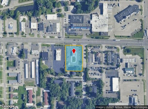
1730 28Th St Sw, Wyoming, MI 49519

NEARBY LISTINGS FOR SALE OR LEASE
Property Detail
1730 28Th St Sw
Grand Rapids-Wyoming-Kentwood, MI
28Th Street Office Plaza
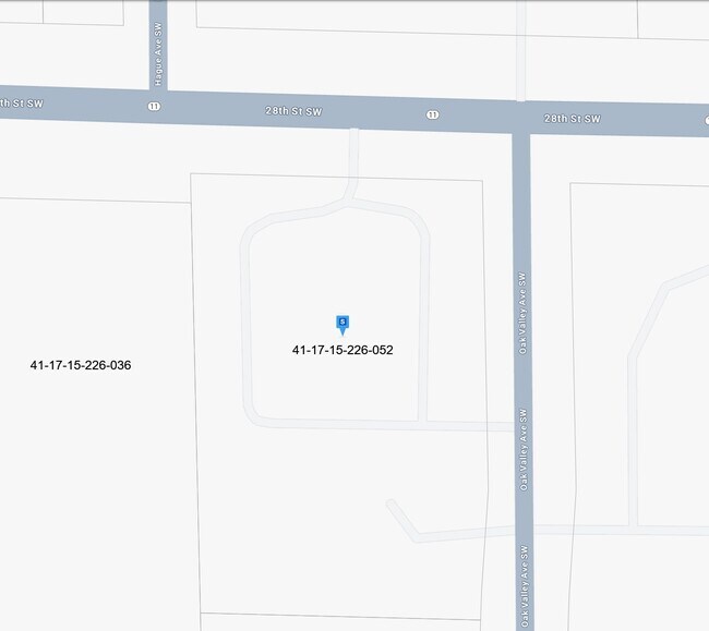
41-17-15-226-052
LOTS 9 & 10 * 28TH STREET OFFICE PLAZA
Commercialnec
Kent
X
Michigan
26081C0412D
9-10
2024
1.36 AC
2025
Southwestern Grand Rapids
013803
West Michigan
5,063 SF
DEMOGRAPHICS near 1730 28Th St Sw
1 Mile
3 Mile
5 Mile
2024 Total Population
14,763
91,911
250,783
2029 Population
14,893
92,253
252,797
Pop Growth 2024-2029
+ 0.88%
+ 0.37%
+ 0.80%
Average Age
36
36
37
2024 Total Households
5,732
33,224
97,850
HH Growth 2024-2029
+ 0.82%
+ 0.48%
+ 0.89%
Median Household Inc
$57,520
$59,416
$62,354
Avg Household Size
2.50
2.60
2.50
2024 Avg HH Vehicles
2.00
2.00
2.00
Median Home Value
$155,626
$161,830
$194,352
Median Year Built
1966
1960
1961
Nearby Places
Map Layers
Map Styles
 Street
 Aerial
- Restaurants
- Banks
- Shops
- Fitness
- Groceries
PUBLIC TRANSPORTATION
COMMUTER RAIL
DRIVE
WALK
Distance
9 min
4.9 mi
AIRPORT
Gerald R Ford International
DRIVE
WALK
Distance
Gerald R Ford International
23 min
12.0 mi
SALE & LEASE HISTORY
LISTING DATE
SALE/LEASE

Sep 17, 2020
For Sale
Sep 13, 2022
For Sale
Mar 07, 2023
For Sale
Jul 25, 2023
For Sale
Dec 03, 2019
For Sale
Aug 26, 2019
For Sale
Aug 11, 2022
For Sale
Nearby Properties
Address
Land Use
TOTAL SIZE
Lot Size
Zoning
Address
Land Use
TOTAL SIZE
Lot Size
Zoning
899,034 SF
78.93 AC
B1
Address
Land Use
TOTAL SIZE
Lot Size
Zoning
560,062 SF
55.39 AC
R4
Address
Land Use
TOTAL SIZE
Lot Size
Zoning
12.64 AC
PUD
Address
Land Use
TOTAL SIZE
Lot Size
Zoning
307,361 SF
16.60 AC
R1-A
Address
Land Use
TOTAL SIZE
Lot Size
Zoning
398,607 SF
33.51 AC
R4
Address
Land Use
TOTAL SIZE
Lot Size
Zoning
87.39 AC
I2
Address
Land Use
TOTAL SIZE
Lot Size
Zoning
13.53 AC
R1-A
Address
Land Use
TOTAL SIZE
Lot Size
Zoning
264,739 SF
26.56 AC
I2
Address
Land Use
TOTAL SIZE
Lot Size
Zoning
22.35 AC
Address
Land Use
TOTAL SIZE
Lot Size
Zoning
536,296 SF
26.16 AC
SD-IT
Address
Land Use
TOTAL SIZE
Lot Size
Zoning
179,436 SF
24.94 AC
I2
Address
Land Use
TOTAL SIZE
Lot Size
Zoning
212,353 SF
16.52 AC
R4
Address
Land Use
TOTAL SIZE
Lot Size
Zoning
20.30 AC
Address
Land Use
TOTAL SIZE
Lot Size
Zoning
29.13 AC
Address
Land Use
TOTAL SIZE
Lot Size
Zoning
293,441 SF
18 AC
I-1
Address
Land Use
TOTAL SIZE
Lot Size
Zoning
251,562 SF
15.56 AC
MZ
Address
Land Use
TOTAL SIZE
Lot Size
Zoning
162,228 SF
14.31 AC
R4
Address
Land Use
TOTAL SIZE
Lot Size
Zoning
Address
Land Use
TOTAL SIZE
Lot Size
Zoning
87,414 SF
14.72 AC
PUD
Address
Land Use
TOTAL SIZE
Lot Size
Zoning
248,360 SF
7.03 AC
SD-IT
Address
Land Use
TOTAL SIZE
Lot Size
Zoning
157,386 SF
13.11 AC
R4
Address
Land Use
TOTAL SIZE
Lot Size
Zoning
61 AC
R6
Address
Land Use
TOTAL SIZE
Lot Size
Zoning
155,304 SF
17.58 AC
R3-B
Address
Land Use
TOTAL SIZE
Lot Size
Zoning
116,832 SF
14.32 AC
R4
Address
Land Use
TOTAL SIZE
Lot Size
Zoning
246,880 SF
18.33 AC
I-2
Address
Land Use
TOTAL SIZE
Lot Size
Zoning
260,000 SF
10.49 AC
SD-IT
Address
Land Use
TOTAL SIZE
Lot Size
Zoning
124,800 SF
11.19 AC
R4
Address
Land Use
TOTAL SIZE
Lot Size
Zoning
121,842 SF
9.42 AC
R4
Address
Land Use
TOTAL SIZE
Lot Size
Zoning
143,447 SF
10.72 AC
R4
Address
Land Use
TOTAL SIZE
Lot Size
Zoning
76.68 AC
I2
The World's #1 Commercial Real Estate Marketplace
Connect with us
© 2026 CoStar Group
The information above has been obtained from sources believed reliable. While we do not doubt its accuracy we have not verified it and make no guarantee, warranty or representation about it. It is your responsibility to independently confirm its accuracy and completeness. Any projections, opinions, assumptions, or estimates used are for example only and do not represent the current or future performance of the property. The value of this transaction to you depends on tax and other factors which should be evaluated by your tax, financial, and legal advisors. You and your advisors should conduct a careful, independent investigation of the property to determine to your satisfaction the suitability of the property for your needs.