Property Record
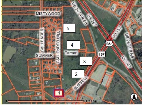
481 Russell Ln, Mansfield, TX 76063

Property Detail
481 Russell Ln
Dallas-Fort Worth-Arlington, TX
OAKDALE ADDITION-MANSFIELD BLOCK 2 LOT 5
01993550
Tarrant
Residentialacreage
Texas
B and X Area of moderate flood hazard, usually the area between the limits of the 100-year and 500-year floods.
5
2024
1.14 AC
2025
Arlington/Mansfield
111406
Dallas/Ft Worth
1,399 SF
NEARBY LISTINGS FOR SALE OR LEASE
-
-
Farm to Market Road 157 Hwy @ Watson Branch Lane
Mansfield, TX 76063
Rent Upon Request
1.38 AC Lots
Land
-
-
-
-
-
-
View all Mansfield listings for sale on LoopNet.com
DEMOGRAPHICS near 481 Russell Ln
1 mile
3 mile
5 mile
2025 Total Population
7,935
65,849
185,944
2030 Population
8,448
69,667
196,658
Pop Growth 2025-2030
+ 6.47%
+ 5.80%
+ 5.76%
Average Age
37
38
38
2025 Total Households
3,016
22,054
61,641
HH Growth 2025-2030
+ 6.90%
+ 6.07%
+ 5.91%
Median Household Inc
$83,506
$103,958
$102,814
Avg Household Size
2.60
2.90
3.00
2025 Avg HH Vehicles
2.00
2.00
2.00
Median Home Value
$374,601
$380,119
$367,924
Median Year Built
2003
2001
2000
Nearby Places
Map Layers
Map Styles
 Street
 Aerial
Transit
 Traffic
 Biking
Places
Listings with unknown addresses are not visible on the map
- Restaurants
- Banks
- Shops
- Fitness
- Groceries
PUBLIC TRANSPORTATION
AIRPORT
Dallas-Fort Worth International
Drive
Walk
Distance
Dallas-Fort Worth International
41 min
27.1 mi
Dallas Love Field
Drive
Walk
Distance
Dallas Love Field
51 min
36.0 mi
SALE & LEASE HISTORY
LISTING DATE
SALE/LEASE

Sep 24, 2016
For Sale
Dec 31, 2020
For Sale
Nearby Properties
Address
Land Use
TOTAL SIZE
Lot Size
Zoning
Address
Land Use
TOTAL SIZE
Lot Size
Zoning
348,951 SF
18.66 AC
Address
Land Use
TOTAL SIZE
Lot Size
Zoning
317,142 SF
11.40 AC
Address
Land Use
TOTAL SIZE
Lot Size
Zoning
160,000 SF
26.90 AC
Address
Land Use
TOTAL SIZE
Lot Size
Zoning
413,000 SF
19.16 AC
Address
Land Use
TOTAL SIZE
Lot Size
Zoning
298,988 SF
7.16 AC
Address
Land Use
TOTAL SIZE
Lot Size
Zoning
276,467 SF
7.61 AC
Address
Land Use
TOTAL SIZE
Lot Size
Zoning
246,204 SF
15.16 AC
Address
Land Use
TOTAL SIZE
Lot Size
Zoning
249,922 SF
17.26 AC
Address
Land Use
TOTAL SIZE
Lot Size
Zoning
255,134 SF
21.62 AC
Address
Land Use
TOTAL SIZE
Lot Size
Zoning
170,082 SF
36.49 AC
Address
Land Use
TOTAL SIZE
Lot Size
Zoning
724,286 SF
48.41 AC
Address
Land Use
TOTAL SIZE
Lot Size
Zoning
208,630 SF
8.62 AC
Address
Land Use
TOTAL SIZE
Lot Size
Zoning
231,551 SF
25.69 AC
Address
Land Use
TOTAL SIZE
Lot Size
Zoning
171,820 SF
59.63 AC
Address
Land Use
TOTAL SIZE
Lot Size
Zoning
98,664 SF
5.47 AC
Address
Land Use
TOTAL SIZE
Lot Size
Zoning
234,580 SF
65.82 AC
Address
Land Use
TOTAL SIZE
Lot Size
Zoning
229,168 SF
6.13 AC
Address
Land Use
TOTAL SIZE
Lot Size
Zoning
399,496 SF
23.29 AC
Address
Land Use
TOTAL SIZE
Lot Size
Zoning
149,494 SF
3.73 AC
Address
Land Use
TOTAL SIZE
Lot Size
Zoning
125,000 SF
18.37 AC
Address
Land Use
TOTAL SIZE
Lot Size
Zoning
663,733 SF
7.77 AC
Address
Land Use
TOTAL SIZE
Lot Size
Zoning
79,070 SF
11.98 AC
Address
Land Use
TOTAL SIZE
Lot Size
Zoning
92,456 SF
5.14 AC
Address
Land Use
TOTAL SIZE
Lot Size
Zoning
84,237 SF
22.89 AC
Address
Land Use
TOTAL SIZE
Lot Size
Zoning
275,337 SF
14 AC
Address
Land Use
TOTAL SIZE
Lot Size
Zoning
130,800 SF
19.61 AC
Address
Land Use
TOTAL SIZE
Lot Size
Zoning
85,000 SF
13.03 AC
Address
Land Use
TOTAL SIZE
Lot Size
Zoning
158,103 SF
13.27 AC
Address
Land Use
TOTAL SIZE
Lot Size
Zoning
1,300 SF
39.58 AC
Address
Land Use
TOTAL SIZE
Lot Size
Zoning
84,455 SF
12.24 AC
The World's #1 Commercial Real Estate Marketplace
Connect with us
© 2026 CoStar Group
The information above has been obtained from sources believed reliable. While we do not doubt its accuracy we have not verified it and make no guarantee, warranty or representation about it. It is your responsibility to independently confirm its accuracy and completeness. Any projections, opinions, assumptions, or estimates used are for example only and do not represent the current or future performance of the property. The value of this transaction to you depends on tax and other factors which should be evaluated by your tax, financial, and legal advisors. You and your advisors should conduct a careful, independent investigation of the property to determine to your satisfaction the suitability of the property for your needs.