Property Record
1730 E Logan Ave, Emporia, KS 66801


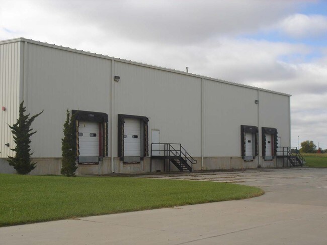

Property Detail
1730 E Logan Ave
196-14-0-00-00-012.00-0
WILSON-DAVIS 1ST, S14, T19S, R11E, LOT 12, ACRES 9.9, (643.0 X 680.0)
Heavyindustrial
Lyon
I1
Kansas
B and X Area of moderate flood hazard, usually the area between the limits of the 100-year and 500-year floods.
12
2025
9.99 AC
2025
Kansas Area
000500
Other Market Areas
28,689 SF
Emporia, KS
NEARBY LISTINGS FOR SALE OR LEASE
-
-
View all Emporia listings for sale on LoopNet.com
DEMOGRAPHICS near 1730 E Logan Ave
1 mile
3 mile
5 mile
2025 Total Population
1,545
17,924
25,796
2030 Population
1,579
18,294
26,288
Pop Growth 2025-2030
+ 2.20%
+ 2.06%
+ 1.91%
Average Age
39
35
37
2025 Total Households
621
7,351
10,548
HH Growth 2025-2030
+ 2.58%
+ 2.19%
+ 1.97%
Median Household Inc
$52,831
$49,411
$54,091
Avg Household Size
2.40
2.20
2.30
2025 Avg HH Vehicles
2.00
2.00
2.00
Median Home Value
$76,324
$107,222
$138,848
Median Year Built
1970
1960
1968
Nearby Places
Map Layers
Map Styles
 Street
 Aerial
Layers
 Traffic
 Biking
Places
Listings with unknown addresses are not visible on the map
- Restaurants
- Banks
- Shops
- Fitness
- Groceries
Nearby Properties
Address
Land Use
TOTAL SIZE
Lot Size
Zoning
Address
Land Use
TOTAL SIZE
Lot Size
Zoning
97,645 SF
116.32 AC
P
Address
Land Use
TOTAL SIZE
Lot Size
Zoning
91,154 SF
2.28 AC
R3
Address
Land Use
TOTAL SIZE
Lot Size
Zoning
60,239 SF
23.20 AC
P
Address
Land Use
TOTAL SIZE
Lot Size
Zoning
2,816 SF
10.57 AC
P
Address
Land Use
TOTAL SIZE
Lot Size
Zoning
102,522 SF
1.12 AC
P
Address
Land Use
TOTAL SIZE
Lot Size
Zoning
224,765 SF
10.51 AC
Address
Land Use
TOTAL SIZE
Lot Size
Zoning
530,015 SF
81.05 AC
I1
Address
Land Use
TOTAL SIZE
Lot Size
Zoning
36,648 SF
79.21 AC
P
Address
Land Use
TOTAL SIZE
Lot Size
Zoning
11,743 SF
4.63 AC
P
Address
Land Use
TOTAL SIZE
Lot Size
Zoning
574,171 SF
81.36 AC
I1
Address
Land Use
TOTAL SIZE
Lot Size
Zoning
34,403 SF
1.12 AC
P
Address
Land Use
TOTAL SIZE
Lot Size
Zoning
28,336 SF
0.37 AC
C4
Address
Land Use
TOTAL SIZE
Lot Size
Zoning
44,449 SF
3.90 AC
P
Address
Land Use
TOTAL SIZE
Lot Size
Zoning
0.92 AC
Address
Land Use
TOTAL SIZE
Lot Size
Zoning
23,316 SF
0.45 AC
R3
Address
Land Use
TOTAL SIZE
Lot Size
Zoning
63,004 SF
2.25 AC
P
Address
Land Use
TOTAL SIZE
Lot Size
Zoning
36,530 SF
7.08 AC
P
Address
Land Use
TOTAL SIZE
Lot Size
Zoning
16,800 SF
5.95 AC
AL
Address
Land Use
TOTAL SIZE
Lot Size
Zoning
25,596 SF
6.50 AC
R3
Address
Land Use
TOTAL SIZE
Lot Size
Zoning
2,450 SF
41 AC
AL
Address
Land Use
TOTAL SIZE
Lot Size
Zoning
382,437 SF
111.11 AC
I1
Address
Land Use
TOTAL SIZE
Lot Size
Zoning
7,058 SF
27.91 AC
I2
Address
Land Use
TOTAL SIZE
Lot Size
Zoning
6,924 SF
3.92 AC
R1
Address
Land Use
TOTAL SIZE
Lot Size
Zoning
8,771 SF
3.23 AC
Address
Land Use
TOTAL SIZE
Lot Size
Zoning
35,710 SF
2.57 AC
P
Address
Land Use
TOTAL SIZE
Lot Size
Zoning
32,799 SF
0.90 AC
C4
Address
Land Use
TOTAL SIZE
Lot Size
Zoning
9,764 SF
1.08 AC
R3
Address
Land Use
TOTAL SIZE
Lot Size
Zoning
19,568 SF
0.42 AC
C4
Address
Land Use
TOTAL SIZE
Lot Size
Zoning
318,602 SF
16.05 AC
I1
Address
Land Use
TOTAL SIZE
Lot Size
Zoning
30,921 SF
1.53 AC
P
The World's #1 Commercial Real Estate Marketplace
Connect with us
© 2026 CoStar Group
The information above has been obtained from sources believed reliable. While we do not doubt its accuracy we have not verified it and make no guarantee, warranty or representation about it. It is your responsibility to independently confirm its accuracy and completeness. Any projections, opinions, assumptions, or estimates used are for example only and do not represent the current or future performance of the property. The value of this transaction to you depends on tax and other factors which should be evaluated by your tax, financial, and legal advisors. You and your advisors should conduct a careful, independent investigation of the property to determine to your satisfaction the suitability of the property for your needs.