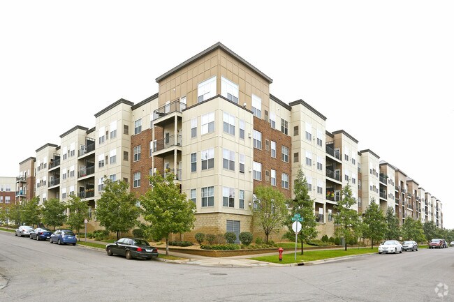
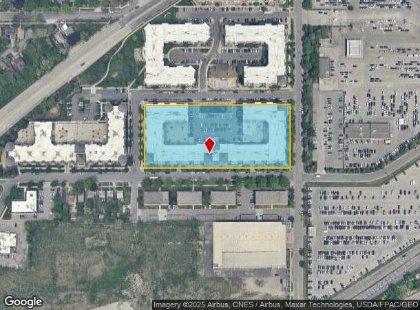
Property Record
1730 Graham Ave, Saint Paul, MN 55116
NEARBY LISTINGS FOR SALE OR LEASE
Property Detail
1730 Graham Ave
Minneapolis-St. Paul-Bloomington, MN-WI
Gateway Village
21-28-23-13-0141
GATEWAY VILLAGE LOT 1 BLK 2
Apartment
Ramsey
X
Minnesota
27053C0393F
1
2024
3.42 AC
2025
Highland
037604
Minneapolis/St Paul
378,880 SF
DEMOGRAPHICS near 1730 Graham Ave
1 Mile
3 Mile
5 Mile
2024 Total Population
10,089
79,277
277,898
2029 Population
9,891
77,841
274,561
Pop Growth 2024-2029
(1.96%)
(1.81%)
(1.20%)
Average Age
41
42
39
2024 Total Households
4,702
34,964
119,211
HH Growth 2024-2029
(2.13%)
(2.03%)
(1.27%)
Median Household Inc
$61,296
$85,201
$77,118
Avg Household Size
2.10
2.10
2.20
2024 Avg HH Vehicles
1.00
2.00
2.00
Median Home Value
$341,621
$364,541
$326,179
Median Year Built
1972
1953
1951
Nearby Places
Map Layers
Map Styles
 Street
 Aerial
- Restaurants
- Banks
- Shops
- Fitness
- Groceries
PUBLIC TRANSPORTATION
COMMUTER RAIL
St. Paul-Minneapolis (Empire Builder - Amtrak)
DRIVE
WALK
Distance
St. Paul-Minneapolis (Empire Builder - Amtrak)
9 min
6.2 mi
Target Field Station (Northstar Corridor - Northstar Commuter Rail)
DRIVE
WALK
Distance
Target Field Station (Northstar Corridor - Northstar Commuter Rail)
21 min
9.7 mi
AIRPORT
Minneapolis-St Paul International/Wold-Chamberlain
DRIVE
WALK
Distance
Minneapolis-St Paul International/Wold-Chamberlain
7 min
3.8 mi
Freight Ports
Port Milwaukee
DRIVE
WALK
Distance
Port Milwaukee
369 min
334.8 mi
Nearby Properties
Address
Land Use
TOTAL SIZE
Lot Size
Zoning
Address
Land Use
TOTAL SIZE
Lot Size
Zoning
84,316 SF
40.83 AC
Address
Land Use
TOTAL SIZE
Lot Size
Zoning
504,049 SF
75.43 AC
Address
Land Use
TOTAL SIZE
Lot Size
Zoning
2.65 AC
Address
Land Use
TOTAL SIZE
Lot Size
Zoning
267,530 SF
28.60 AC
Address
Land Use
TOTAL SIZE
Lot Size
Zoning
173.22 AC
Address
Land Use
TOTAL SIZE
Lot Size
Zoning
Address
Land Use
TOTAL SIZE
Lot Size
Zoning
387,902 SF
14.81 AC
Address
Land Use
TOTAL SIZE
Lot Size
Zoning
429,720 SF
6.02 AC
Address
Land Use
TOTAL SIZE
Lot Size
Zoning
247,470 SF
2.21 AC
Address
Land Use
TOTAL SIZE
Lot Size
Zoning
279,247 SF
1.65 AC
Address
Land Use
TOTAL SIZE
Lot Size
Zoning
233,578 SF
9.56 AC
Address
Land Use
TOTAL SIZE
Lot Size
Zoning
237,685 SF
2.22 AC
Address
Land Use
TOTAL SIZE
Lot Size
Zoning
Address
Land Use
TOTAL SIZE
Lot Size
Zoning
437,524 SF
6.11 AC
Address
Land Use
TOTAL SIZE
Lot Size
Zoning
233,588 SF
2.35 AC
Address
Land Use
TOTAL SIZE
Lot Size
Zoning
288,834 SF
1.72 AC
Address
Land Use
TOTAL SIZE
Lot Size
Zoning
2.18 AC
Address
Land Use
TOTAL SIZE
Lot Size
Zoning
Address
Land Use
TOTAL SIZE
Lot Size
Zoning
Address
Land Use
TOTAL SIZE
Lot Size
Zoning
44,672 SF
63.51 AC
Address
Land Use
TOTAL SIZE
Lot Size
Zoning
165,618 SF
12.37 AC
Address
Land Use
TOTAL SIZE
Lot Size
Zoning
223,680 SF
2.61 AC
R5
Address
Land Use
TOTAL SIZE
Lot Size
Zoning
196,178 SF
1.26 AC
C3A
Address
Land Use
TOTAL SIZE
Lot Size
Zoning
16,075 SF
177.89 AC
Address
Land Use
TOTAL SIZE
Lot Size
Zoning
305,011 SF
8.61 AC
Address
Land Use
TOTAL SIZE
Lot Size
Zoning
Address
Land Use
TOTAL SIZE
Lot Size
Zoning
8,208 SF
0.71 AC
Address
Land Use
TOTAL SIZE
Lot Size
Zoning
Address
Land Use
TOTAL SIZE
Lot Size
Zoning
169,522 SF
1.45 AC
C3A
The World's #1 Commercial Real Estate Marketplace
Connect with us
© 2025 CoStar Group
The information above has been obtained from sources believed reliable. While we do not doubt its accuracy we have not verified it and make no guarantee, warranty or representation about it. It is your responsibility to independently confirm its accuracy and completeness. Any projections, opinions, assumptions, or estimates used are for example only and do not represent the current or future performance of the property. The value of this transaction to you depends on tax and other factors which should be evaluated by your tax, financial, and legal advisors. You and your advisors should conduct a careful, independent investigation of the property to determine to your satisfaction the suitability of the property for your needs.