Property Record
1730 N Goodman St, Rochester, NY 14609
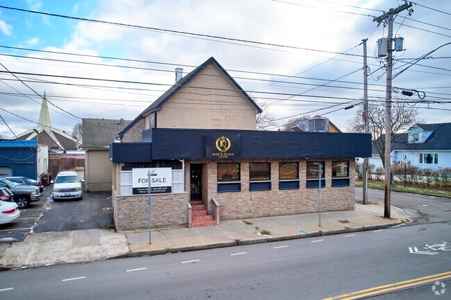
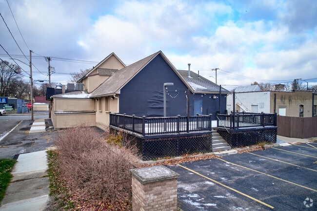
This Property Is For Sale
NEARBY LISTINGS FOR SALE OR LEASE
Property Detail
1730 N Goodman St
261400-092-610-0002-065-000-0000
0082.00 104 22 03134 5 & PT 4 SCHAEFFER TER
Restaurantbuilding
Monroe
X
New York
36055C0212G
65.000
2025
0.14 AC
2024
Greater Rochester
008200
Rochester
4,271 SF
Rochester, NY
DEMOGRAPHICS near 1730 N Goodman St
1 Mile
3 Mile
5 Mile
2024 Total Population
22,431
141,082
302,807
2029 Population
22,024
139,013
298,095
Pop Growth 2024-2029
(1.81%)
(1.47%)
(1.56%)
Average Age
38
39
39
2024 Total Households
8,842
64,021
133,245
HH Growth 2024-2029
(1.83%)
(1.43%)
(1.58%)
Median Household Inc
$42,066
$49,835
$52,478
Avg Household Size
2.40
2.10
2.20
2024 Avg HH Vehicles
1.00
1.00
1.00
Median Home Value
$76,462
$138,577
$148,344
Median Year Built
1950
1949
1949
Nearby Places
- Restaurants
- Banks
- Shops
- Fitness
- Groceries
PUBLIC TRANSPORTATION
COMMUTER RAIL
Rochester (Empire Service - VIA Rail, Lake Shore Limited - VIA Rail, Maple Leaf - VIA Rail, Toronto - New York - VIA Rail)
DRIVE
WALK
Distance
Rochester (Empire Service - VIA Rail, Lake Shore Limited - VIA Rail, Maple Leaf - VIA Rail, Toronto - New York - VIA Rail)
5 min
2.8 mi
AIRPORT
Frederick Douglass/Greater Rochester International
DRIVE
WALK
Distance
Frederick Douglass/Greater Rochester International
14 min
8.0 mi
Freight Ports
Albany, NY Port
DRIVE
WALK
Distance
Albany, NY Port
268 min
227.7 mi
Nearby Properties
Address
Land Use
TOTAL SIZE
Lot Size
Zoning
Address
Land Use
TOTAL SIZE
Lot Size
Zoning
847,728 SF
41.57 AC
Address
Land Use
TOTAL SIZE
Lot Size
Zoning
0.47 AC
Address
Land Use
TOTAL SIZE
Lot Size
Zoning
0.13 AC
Address
Land Use
TOTAL SIZE
Lot Size
Zoning
270,150 SF
34.40 AC
02 - SINGL
Address
Land Use
TOTAL SIZE
Lot Size
Zoning
13.10 AC
Address
Land Use
TOTAL SIZE
Lot Size
Zoning
373,200 SF
5.42 AC
Address
Land Use
TOTAL SIZE
Lot Size
Zoning
178,321 SF
3.10 AC
Address
Land Use
TOTAL SIZE
Lot Size
Zoning
0.01 AC
Address
Land Use
TOTAL SIZE
Lot Size
Zoning
302,484 SF
2.53 AC
Address
Land Use
TOTAL SIZE
Lot Size
Zoning
473,876 SF
1.49 AC
Address
Land Use
TOTAL SIZE
Lot Size
Zoning
342,266 SF
1.44 AC
Address
Land Use
TOTAL SIZE
Lot Size
Zoning
7,200 SF
12.35 AC
Address
Land Use
TOTAL SIZE
Lot Size
Zoning
0.41 AC
Address
Land Use
TOTAL SIZE
Lot Size
Zoning
0.01 AC
Address
Land Use
TOTAL SIZE
Lot Size
Zoning
416,083 SF
0.94 AC
Address
Land Use
TOTAL SIZE
Lot Size
Zoning
323,264 SF
21.06 AC
06 - INDUS
Address
Land Use
TOTAL SIZE
Lot Size
Zoning
0.01 AC
Address
Land Use
TOTAL SIZE
Lot Size
Zoning
0.65 AC
Address
Land Use
TOTAL SIZE
Lot Size
Zoning
491,375 SF
5.90 AC
Address
Land Use
TOTAL SIZE
Lot Size
Zoning
161,812 SF
5.18 AC
06 - INDUS
Address
Land Use
TOTAL SIZE
Lot Size
Zoning
273,900 SF
0.74 AC
Address
Land Use
TOTAL SIZE
Lot Size
Zoning
336,447 SF
1.38 AC
Address
Land Use
TOTAL SIZE
Lot Size
Zoning
335,918 SF
10.19 AC
Address
Land Use
TOTAL SIZE
Lot Size
Zoning
151,590 SF
1.14 AC
Address
Land Use
TOTAL SIZE
Lot Size
Zoning
233,579 SF
1.13 AC
Address
Land Use
TOTAL SIZE
Lot Size
Zoning
410,400 SF
2.88 AC
Address
Land Use
TOTAL SIZE
Lot Size
Zoning
193,892 SF
18.62 AC
05 - COMME
Address
Land Use
TOTAL SIZE
Lot Size
Zoning
261,960 SF
3.73 AC
Address
Land Use
TOTAL SIZE
Lot Size
Zoning
203,306 SF
3.91 AC
Address
Land Use
TOTAL SIZE
Lot Size
Zoning
1.06 AC
The World's #1 Commercial Real Estate Marketplace
Connect with us
© 2025 CoStar Group
The information above has been obtained from sources believed reliable. While we do not doubt its accuracy we have not verified it and make no guarantee, warranty or representation about it. It is your responsibility to independently confirm its accuracy and completeness. Any projections, opinions, assumptions, or estimates used are for example only and do not represent the current or future performance of the property. The value of this transaction to you depends on tax and other factors which should be evaluated by your tax, financial, and legal advisors. You and your advisors should conduct a careful, independent investigation of the property to determine to your satisfaction the suitability of the property for your needs.