Property Record
1730 Us Highway 22, Bound Brook, NJ 08805
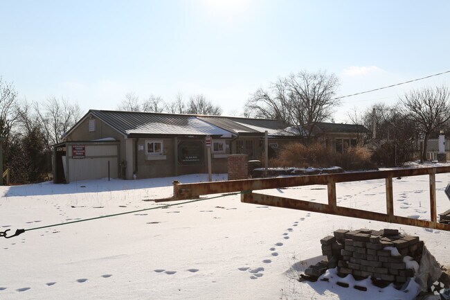

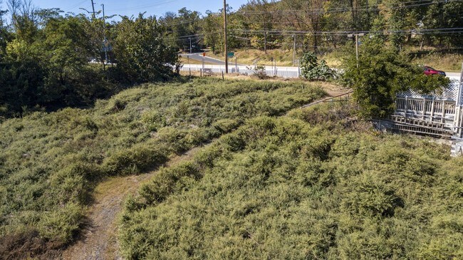
Property Detail
1730 Us Highway 22
06-00367-0000-00024
SOMERSET
Horticulturegrowinghousesagricultural
New Jersey
R20
24
B and X Area of moderate flood hazard, usually the area between the limits of the 100-year and 500-year floods.
2.84 AC
2024
Route 78 East
2025
Northern New Jersey
051000
Lakewood-New Brunswick, NJ
NEARBY LISTINGS FOR SALE OR LEASE
DEMOGRAPHICS near 1730 Us Highway 22
1 mile
3 mile
5 mile
2025 Total Population
10,013
59,770
168,369
2030 Population
10,246
61,882
175,056
Pop Growth 2025-2030
+ 2.33%
+ 3.53%
+ 3.97%
Average Age
40
41
42
2025 Total Households
3,552
21,472
61,269
HH Growth 2025-2030
+ 2.53%
+ 3.75%
+ 4.18%
Median Household Inc
$109,787
$123,360
$124,993
Avg Household Size
2.80
2.70
2.70
2025 Avg HH Vehicles
2.00
2.00
2.00
Median Home Value
$452,669
$469,367
$482,647
Median Year Built
1956
1967
1969
Nearby Places
Map Layers
Map Styles
 Street
 Aerial
Layers
 Traffic
 Biking
Places
Listings with unknown addresses are not visible on the map
- Restaurants
- Banks
- Shops
- Fitness
- Groceries
PUBLIC TRANSPORTATION
COMMUTER RAIL
Bound Brook (Raritan Valley Line - NJ Transit Commuter Rail (NJ Transit))
Drive
Walk
Distance
Bound Brook (Raritan Valley Line - NJ Transit Commuter Rail (NJ Transit))
5 min
2.1 mi
Bridgewater (Raritan Valley Line - NJ Transit Commuter Rail (NJ Transit))
Drive
Walk
Distance
Bridgewater (Raritan Valley Line - NJ Transit Commuter Rail (NJ Transit))
8 min
3.2 mi
AIRPORT
Newark Liberty International
Drive
Walk
Distance
Newark Liberty International
37 min
26.8 mi
Trenton Mercer
Drive
Walk
Distance
Trenton Mercer
58 min
36.2 mi
Freight Ports
Maher Terminal
Drive
Walk
Distance
Maher Terminal
41 min
25.5 mi
SALE & LEASE HISTORY
LISTING DATE
SALE/LEASE

Sep 28, 2019
For Sale
Jan 19, 2021
For Sale
Nearby Properties
Address
Land Use
TOTAL SIZE
Lot Size
Zoning
Address
Land Use
TOTAL SIZE
Lot Size
Zoning
13.59 AC
H
Address
Land Use
TOTAL SIZE
Lot Size
Zoning
6,625 SF
22.51 AC
B-I
Address
Land Use
TOTAL SIZE
Lot Size
Zoning
70.22 AC
B-I
Address
Land Use
TOTAL SIZE
Lot Size
Zoning
17.01 AC
B-I
Address
Land Use
TOTAL SIZE
Lot Size
Zoning
19.46 AC
B-I
Address
Land Use
TOTAL SIZE
Lot Size
Zoning
39.10 AC
C3
Address
Land Use
TOTAL SIZE
Lot Size
Zoning
31.50 AC
B-I
Address
Land Use
TOTAL SIZE
Lot Size
Zoning
22.75 AC
LC
Address
Land Use
TOTAL SIZE
Lot Size
Zoning
310,200 SF
26.23 AC
B-I
Address
Land Use
TOTAL SIZE
Lot Size
Zoning
32.92 AC
B-I
Address
Land Use
TOTAL SIZE
Lot Size
Zoning
Address
Land Use
TOTAL SIZE
Lot Size
Zoning
24.34 AC
IND
Address
Land Use
TOTAL SIZE
Lot Size
Zoning
82.79 AC
M2
Address
Land Use
TOTAL SIZE
Lot Size
Zoning
4.05 AC
Address
Land Use
TOTAL SIZE
Lot Size
Zoning
13.38 AC
B2
Address
Land Use
TOTAL SIZE
Lot Size
Zoning
237,360 SF
14.48 AC
B-I
Address
Land Use
TOTAL SIZE
Lot Size
Zoning
19.90 AC
IND
Address
Land Use
TOTAL SIZE
Lot Size
Zoning
19.63 AC
B-I
Address
Land Use
TOTAL SIZE
Lot Size
Zoning
237,580 SF
22 AC
B-I
Address
Land Use
TOTAL SIZE
Lot Size
Zoning
394 SF
36.05 AC
M105
Address
Land Use
TOTAL SIZE
Lot Size
Zoning
43.63 AC
M1B
Address
Land Use
TOTAL SIZE
Lot Size
Zoning
19.95 AC
M1B
Address
Land Use
TOTAL SIZE
Lot Size
Zoning
30.43 AC
M1A
Address
Land Use
TOTAL SIZE
Lot Size
Zoning
Address
Land Use
TOTAL SIZE
Lot Size
Zoning
190,708 SF
10.73 AC
B-I
Address
Land Use
TOTAL SIZE
Lot Size
Zoning
14.24 AC
RM
Address
Land Use
TOTAL SIZE
Lot Size
Zoning
8.33 AC
GCM
Address
Land Use
TOTAL SIZE
Lot Size
Zoning
51 AC
R40
Address
Land Use
TOTAL SIZE
Lot Size
Zoning
10.95 AC
LC
Address
Land Use
TOTAL SIZE
Lot Size
Zoning
The World's #1 Commercial Real Estate Marketplace
Connect with us
© 2026 CoStar Group
The information above has been obtained from sources believed reliable. While we do not doubt its accuracy we have not verified it and make no guarantee, warranty or representation about it. It is your responsibility to independently confirm its accuracy and completeness. Any projections, opinions, assumptions, or estimates used are for example only and do not represent the current or future performance of the property. The value of this transaction to you depends on tax and other factors which should be evaluated by your tax, financial, and legal advisors. You and your advisors should conduct a careful, independent investigation of the property to determine to your satisfaction the suitability of the property for your needs.