Property Record
17301 Kanis Rd, Little Rock, AR 72223
NEARBY LISTINGS FOR SALE OR LEASE
-
-
-
-
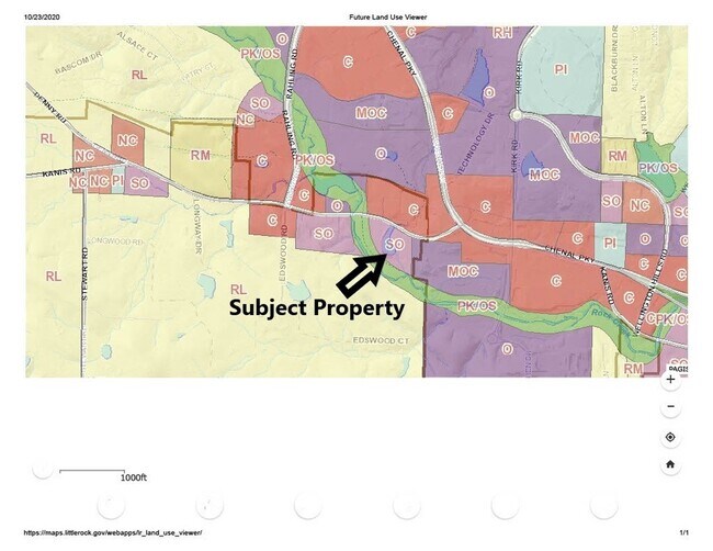
Rahling Road and Chenal Valley Drive
Little Rock, AR 72223
Rent Upon Request
2.01 - 2.76 AC Lot
Land
-
-
-
-
View all Little Rock listings for sale on LoopNet.com
Property Detail
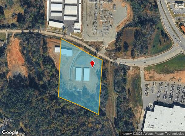
17301 Kanis Rd
Little Rock-North Little Rock-Conway, AR
Independence Farms
54R-001-25-043-00
INDEPENDENCE FARMS TR 37-38 5 78AC
Commercialacreage
Pulaski
AE
Arkansas
05119C0314H
37
2025
5.39 AC
2025
Outlying Pulaski County
004225
Little Rock/N Little Rock
2,162 SF
DEMOGRAPHICS near 17301 Kanis Rd
1 Mile
3 Mile
5 Mile
2024 Total Population
4,031
36,230
79,575
2029 Population
4,048
36,197
79,280
Pop Growth 2024-2029
+ 0.42%
(0.09%)
(0.37%)
Average Age
39
41
40
2024 Total Households
1,659
15,324
34,868
HH Growth 2024-2029
+ 0.24%
(0.14%)
(0.43%)
Median Household Inc
$103,995
$96,985
$77,265
Avg Household Size
2.40
2.30
2.20
2024 Avg HH Vehicles
2.00
2.00
2.00
Median Home Value
$442,473
$321,015
$277,522
Median Year Built
2004
1995
1989
Nearby Places
Map Layers
Map Styles
 Street
 Aerial
- Restaurants
- Banks
- Shops
- Fitness
- Groceries
PUBLIC TRANSPORTATION
AIRPORT
Bill and Hillary Clinton Ntl/Adams Field
DRIVE
WALK
Distance
Bill and Hillary Clinton Ntl/Adams Field
23 min
15.3 mi
SALE & LEASE HISTORY
LISTING DATE
SALE/LEASE

Oct 26, 2020
For Sale
Feb 05, 2018
For Sale
Feb 03, 2020
For Sale
Aug 18, 2017
For Sale
Nearby Properties
Address
Land Use
TOTAL SIZE
Lot Size
Zoning
Address
Land Use
TOTAL SIZE
Lot Size
Zoning
333,636 SF
13.50 AC
Address
Land Use
TOTAL SIZE
Lot Size
Zoning
286,440 SF
10.79 AC
Address
Land Use
TOTAL SIZE
Lot Size
Zoning
115,378 SF
30.50 AC
Address
Land Use
TOTAL SIZE
Lot Size
Zoning
201,059 SF
49.76 AC
Address
Land Use
TOTAL SIZE
Lot Size
Zoning
54,594 SF
16.79 AC
Address
Land Use
TOTAL SIZE
Lot Size
Zoning
48,982 SF
9.06 AC
Address
Land Use
TOTAL SIZE
Lot Size
Zoning
216,869 SF
20.84 AC
Address
Land Use
TOTAL SIZE
Lot Size
Zoning
172,261 SF
5.48 AC
Address
Land Use
TOTAL SIZE
Lot Size
Zoning
127,020 SF
13.56 AC
Address
Land Use
TOTAL SIZE
Lot Size
Zoning
102,600 SF
17.29 AC
Address
Land Use
TOTAL SIZE
Lot Size
Zoning
125,107 SF
22.09 AC
Address
Land Use
TOTAL SIZE
Lot Size
Zoning
168,221 SF
12.02 AC
Address
Land Use
TOTAL SIZE
Lot Size
Zoning
32,562 SF
13.40 AC
Address
Land Use
TOTAL SIZE
Lot Size
Zoning
210,924 SF
22.66 AC
Address
Land Use
TOTAL SIZE
Lot Size
Zoning
91,384 SF
8.34 AC
Address
Land Use
TOTAL SIZE
Lot Size
Zoning
115,062 SF
10.04 AC
Address
Land Use
TOTAL SIZE
Lot Size
Zoning
86,186 SF
13.24 AC
Address
Land Use
TOTAL SIZE
Lot Size
Zoning
160,068 SF
18.91 AC
Address
Land Use
TOTAL SIZE
Lot Size
Zoning
238,164 SF
34.25 AC
Address
Land Use
TOTAL SIZE
Lot Size
Zoning
155,943 SF
10.59 AC
Address
Land Use
TOTAL SIZE
Lot Size
Zoning
21,640 SF
20 AC
Address
Land Use
TOTAL SIZE
Lot Size
Zoning
40,803 SF
18.48 AC
Address
Land Use
TOTAL SIZE
Lot Size
Zoning
129,239 SF
9.01 AC
Address
Land Use
TOTAL SIZE
Lot Size
Zoning
30,040 SF
10.80 AC
Address
Land Use
TOTAL SIZE
Lot Size
Zoning
93,175 SF
4.74 AC
Address
Land Use
TOTAL SIZE
Lot Size
Zoning
123,661 SF
14.71 AC
Address
Land Use
TOTAL SIZE
Lot Size
Zoning
19,471 SF
11.29 AC
Address
Land Use
TOTAL SIZE
Lot Size
Zoning
87,464 SF
9.27 AC
Address
Land Use
TOTAL SIZE
Lot Size
Zoning
93,449 SF
15.21 AC
Address
Land Use
TOTAL SIZE
Lot Size
Zoning
56,912 SF
12.22 AC
The World's #1 Commercial Real Estate Marketplace
Connect with us
© 2026 CoStar Group
The information above has been obtained from sources believed reliable. While we do not doubt its accuracy we have not verified it and make no guarantee, warranty or representation about it. It is your responsibility to independently confirm its accuracy and completeness. Any projections, opinions, assumptions, or estimates used are for example only and do not represent the current or future performance of the property. The value of this transaction to you depends on tax and other factors which should be evaluated by your tax, financial, and legal advisors. You and your advisors should conduct a careful, independent investigation of the property to determine to your satisfaction the suitability of the property for your needs.