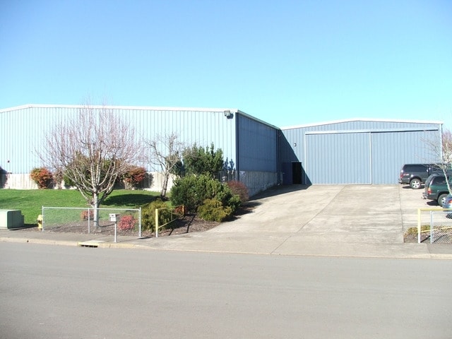
Property Record
1731 Industrial Way, Philomath, OR 97370


Save to a Folder
{{folder.Name}}
{{folder.ListingIds.length}} Properties
{{folder.ListingIds.length}} Property
Create a New Folder
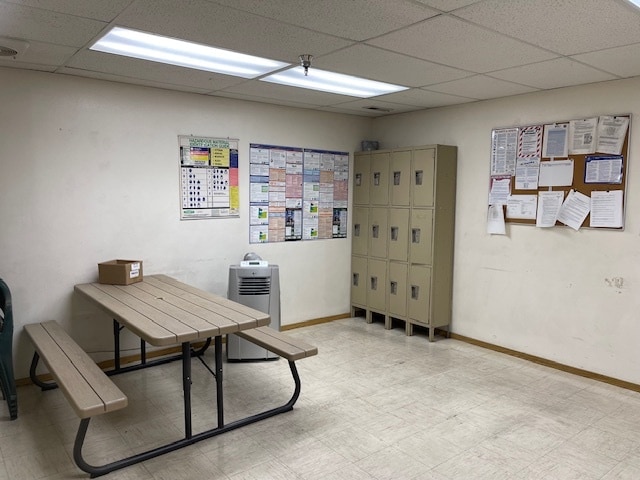
Property Detail
1731 Industrial Way
279491
PHILOMATH INDUSTRIAL PARK
Commercialbuilding
Benton
IL
Oregon
AE The base floodplain where base flood elevations are provided. AE Zones are now used on new format FIRMs instead of A1-A30 Zones.
4.87 AC
2025
Oregon West Area
2025
Other Market Areas
010800
Corvallis, OR
NEARBY LISTINGS FOR SALE OR LEASE
-
-
View all Philomath listings for lease on LoopNet.com
DEMOGRAPHICS near 1731 Industrial Way
1 mile
3 mile
5 mile
2025 Total Population
3,735
13,770
59,908
2030 Population
3,810
14,094
62,578
Pop Growth 2025-2030
+ 2.01%
+ 2.35%
+ 4.46%
Average Age
41
42
37
2025 Total Households
1,448
5,643
23,441
HH Growth 2025-2030
+ 1.93%
+ 2.39%
+ 4.89%
Median Household Inc
$79,167
$90,404
$64,135
Avg Household Size
2.50
2.40
2.20
2025 Avg HH Vehicles
2.00
2.00
2.00
Median Home Value
$406,190
$564,767
$562,685
Median Year Built
1977
1992
1982
Nearby Places
Map Layers
Map Styles
 Street
 Aerial
Layers
 Traffic
 Biking
Places
Listings with unknown addresses are not visible on the map
- Restaurants
- Banks
- Shops
- Fitness
- Groceries
PUBLIC TRANSPORTATION
AIRPORT
Mahlon Sweet Field
Drive
Walk
Distance
Mahlon Sweet Field
63 min
39.1 mi
SALE & LEASE HISTORY
LISTING DATE
SALE/LEASE

Sep 18, 2025
For Sale
Oct 27, 2025
For Lease
Nearby Properties
Address
Land Use
TOTAL SIZE
Lot Size
Zoning
Address
Land Use
TOTAL SIZE
Lot Size
Zoning
241,599 SF
14.33 AC
R-3
Address
Land Use
TOTAL SIZE
Lot Size
Zoning
107,412 SF
9.16 AC
RTC
Address
Land Use
TOTAL SIZE
Lot Size
Zoning
235,104 SF
9.96 AC
PD(RS-20)
Address
Land Use
TOTAL SIZE
Lot Size
Zoning
67,923 SF
4.84 AC
RTC
Address
Land Use
TOTAL SIZE
Lot Size
Zoning
121,330 SF
10.62 AC
PD(RS-12)
Address
Land Use
TOTAL SIZE
Lot Size
Zoning
15.04 AC
RI
Address
Land Use
TOTAL SIZE
Lot Size
Zoning
94,542 SF
10.96 AC
PD(NC-MAJO
Address
Land Use
TOTAL SIZE
Lot Size
Zoning
123,198 SF
6.12 AC
PD(RS-20)
Address
Land Use
TOTAL SIZE
Lot Size
Zoning
111,577 SF
4.72 AC
RS-20
Address
Land Use
TOTAL SIZE
Lot Size
Zoning
106,912 SF
4.05 AC
PD(RS-12)
Address
Land Use
TOTAL SIZE
Lot Size
Zoning
76,624 SF
3.40 AC
PD(RS-12)
Address
Land Use
TOTAL SIZE
Lot Size
Zoning
103,024 SF
4.53 AC
PD(RS-20)
Address
Land Use
TOTAL SIZE
Lot Size
Zoning
Address
Land Use
TOTAL SIZE
Lot Size
Zoning
44,125 SF
2.36 AC
PD(RS-12)
Address
Land Use
TOTAL SIZE
Lot Size
Zoning
Address
Land Use
TOTAL SIZE
Lot Size
Zoning
151,681 SF
17.22 AC
IO
Address
Land Use
TOTAL SIZE
Lot Size
Zoning
Address
Land Use
TOTAL SIZE
Lot Size
Zoning
33,465 SF
1.22 AC
RS-12
Address
Land Use
TOTAL SIZE
Lot Size
Zoning
75,776 SF
3.18 AC
MURM
Address
Land Use
TOTAL SIZE
Lot Size
Zoning
40,239 SF
2.51 AC
RS-20
Address
Land Use
TOTAL SIZE
Lot Size
Zoning
Address
Land Use
TOTAL SIZE
Lot Size
Zoning
Address
Land Use
TOTAL SIZE
Lot Size
Zoning
Address
Land Use
TOTAL SIZE
Lot Size
Zoning
1 SF
27.73 AC
IH
Address
Land Use
TOTAL SIZE
Lot Size
Zoning
Address
Land Use
TOTAL SIZE
Lot Size
Zoning
33,150 SF
1.91 AC
RTC
Address
Land Use
TOTAL SIZE
Lot Size
Zoning
15,964 SF
0.85 AC
RS-12
Address
Land Use
TOTAL SIZE
Lot Size
Zoning
1 SF
19.64 AC
UI
Address
Land Use
TOTAL SIZE
Lot Size
Zoning
Address
Land Use
TOTAL SIZE
Lot Size
Zoning
22.90 AC
RI
The World's #1 Commercial Real Estate Marketplace
Connect with us
© 2026 CoStar Group
The information above has been obtained from sources believed reliable. While we do not doubt its accuracy we have not verified it and make no guarantee, warranty or representation about it. It is your responsibility to independently confirm its accuracy and completeness. Any projections, opinions, assumptions, or estimates used are for example only and do not represent the current or future performance of the property. The value of this transaction to you depends on tax and other factors which should be evaluated by your tax, financial, and legal advisors. You and your advisors should conduct a careful, independent investigation of the property to determine to your satisfaction the suitability of the property for your needs.