Property Record
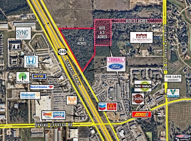
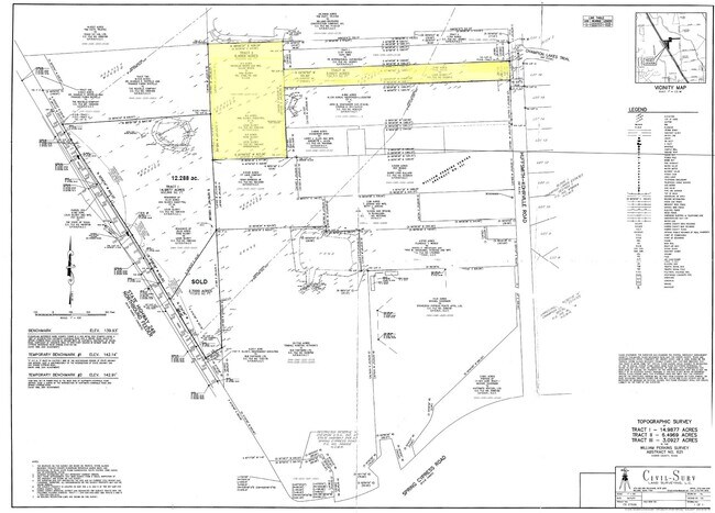
17319 Hufsmith Kohrville Rd, Tomball, TX 77375
NEARBY LISTINGS FOR SALE OR LEASE
Property Detail
17319 Hufsmith Kohrville Rd
Houston-The Woodlands-Sugar Land, TX
Abst 621 W Perkins
0440460000138
TR 26E ABST 621 W PERKINS
Commercialacreage
Harris
AE
Texas
48201C0240M
3.19 AC
2024
Northwest Outlier
2025
Houston
554807
DEMOGRAPHICS near 17319 Hufsmith Kohrville Rd
1 Mile
3 Mile
5 Mile
2024 Total Population
6,940
100,938
229,215
2029 Population
7,040
102,474
233,241
Pop Growth 2024-2029
+ 1.44%
+ 1.52%
+ 1.76%
Average Age
36
38
38
2024 Total Households
2,254
34,627
80,696
HH Growth 2024-2029
+ 1.46%
+ 1.55%
+ 1.73%
Median Household Inc
$103,008
$108,708
$95,024
Avg Household Size
3.00
2.90
2.80
2024 Avg HH Vehicles
2.00
2.00
2.00
Median Home Value
$273,723
$279,954
$286,152
Median Year Built
2006
2001
2000
Nearby Places
- Restaurants
- Banks
- Shops
- Fitness
- Groceries
PUBLIC TRANSPORTATION
AIRPORT
George Bush Intcntl/Houston
DRIVE
WALK
Distance
George Bush Intcntl/Houston
29 min
22.0 mi
William P Hobby
DRIVE
WALK
Distance
William P Hobby
57 min
37.1 mi
Freight Ports
Port of Houston
DRIVE
WALK
Distance
Port of Houston
49 min
32.7 mi
SALE & LEASE HISTORY
LISTING DATE
SALE/LEASE

Feb 04, 2020
For Sale
Nearby Properties
Address
Land Use
TOTAL SIZE
Lot Size
Zoning
Address
Land Use
TOTAL SIZE
Lot Size
Zoning
1,648,539 SF
28.70 AC
Address
Land Use
TOTAL SIZE
Lot Size
Zoning
339,067 SF
34.40 AC
Address
Land Use
TOTAL SIZE
Lot Size
Zoning
427,317 SF
14.16 AC
Address
Land Use
TOTAL SIZE
Lot Size
Zoning
1,073,104 SF
4.74 AC
Address
Land Use
TOTAL SIZE
Lot Size
Zoning
227,400 SF
2.77 AC
Address
Land Use
TOTAL SIZE
Lot Size
Zoning
386,754 SF
17.99 AC
Address
Land Use
TOTAL SIZE
Lot Size
Zoning
507,035 SF
24.90 AC
Address
Land Use
TOTAL SIZE
Lot Size
Zoning
398,856 SF
12.76 AC
Address
Land Use
TOTAL SIZE
Lot Size
Zoning
263,640 SF
36.62 AC
Address
Land Use
TOTAL SIZE
Lot Size
Zoning
332,688 SF
24.57 AC
Address
Land Use
TOTAL SIZE
Lot Size
Zoning
333,337 SF
21.66 AC
Address
Land Use
TOTAL SIZE
Lot Size
Zoning
351,343 SF
12.82 AC
Address
Land Use
TOTAL SIZE
Lot Size
Zoning
262,163 SF
8.63 AC
Address
Land Use
TOTAL SIZE
Lot Size
Zoning
387,938 SF
16.05 AC
Address
Land Use
TOTAL SIZE
Lot Size
Zoning
256,761 SF
8.78 AC
Address
Land Use
TOTAL SIZE
Lot Size
Zoning
393,751 SF
17.08 AC
Address
Land Use
TOTAL SIZE
Lot Size
Zoning
371,761 SF
12.71 AC
Address
Land Use
TOTAL SIZE
Lot Size
Zoning
181,542 SF
8 AC
Address
Land Use
TOTAL SIZE
Lot Size
Zoning
231,734 SF
8.48 AC
Address
Land Use
TOTAL SIZE
Lot Size
Zoning
335,954 SF
35.27 AC
Address
Land Use
TOTAL SIZE
Lot Size
Zoning
80,004 SF
4.41 AC
Address
Land Use
TOTAL SIZE
Lot Size
Zoning
300,080 SF
13.86 AC
Address
Land Use
TOTAL SIZE
Lot Size
Zoning
245,453 SF
10.11 AC
Address
Land Use
TOTAL SIZE
Lot Size
Zoning
314,385 SF
13.78 AC
Address
Land Use
TOTAL SIZE
Lot Size
Zoning
127,408 SF
3.08 AC
Address
Land Use
TOTAL SIZE
Lot Size
Zoning
177,104 SF
14.30 AC
Address
Land Use
TOTAL SIZE
Lot Size
Zoning
127,570 SF
33.51 AC
Address
Land Use
TOTAL SIZE
Lot Size
Zoning
64,284 SF
4.06 AC
Address
Land Use
TOTAL SIZE
Lot Size
Zoning
235,992 SF
15.94 AC
Address
Land Use
TOTAL SIZE
Lot Size
Zoning
129,174 SF
13.65 AC
The World's #1 Commercial Real Estate Marketplace
Connect with us
© 2025 CoStar Group
The information above has been obtained from sources believed reliable. While we do not doubt its accuracy we have not verified it and make no guarantee, warranty or representation about it. It is your responsibility to independently confirm its accuracy and completeness. Any projections, opinions, assumptions, or estimates used are for example only and do not represent the current or future performance of the property. The value of this transaction to you depends on tax and other factors which should be evaluated by your tax, financial, and legal advisors. You and your advisors should conduct a careful, independent investigation of the property to determine to your satisfaction the suitability of the property for your needs.