Property Record
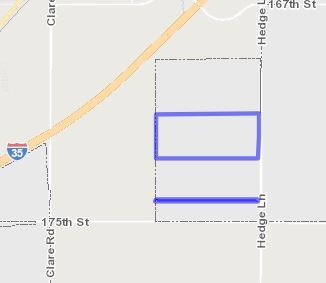
17320 S Hedge Ln, Olathe, KS 66062

Property Detail
17320 S Hedge Ln
Kansas City, MO-KS
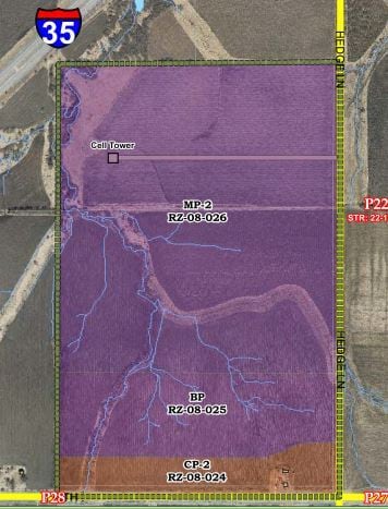
175TH STREET COMMERCE CENTRE, LOT 1
DP55550000-0001
JOHNSON
Warehouse
Kansas
MP-2
1
2024
57.62 AC
2025
South Johnson County
053507
Kansas City
1,060,732 SF
NEARBY LISTINGS FOR SALE OR LEASE
DEMOGRAPHICS near 17320 S Hedge Ln
1 mile
3 mile
5 mile
2025 Total Population
426
8,698
75,646
2030 Population
439
9,080
78,612
Pop Growth 2025-2030
+ 3.05%
+ 4.39%
+ 3.92%
Average Age
41
37
37
2025 Total Households
151
2,770
25,688
HH Growth 2025-2030
+ 3.31%
+ 4.84%
+ 4.12%
Median Household Inc
$100,463
$88,095
$107,256
Avg Household Size
2.80
2.80
2.80
2025 Avg HH Vehicles
2.00
2.00
2.00
Median Home Value
$419,149
$291,257
$346,875
Median Year Built
1988
2000
1998
Nearby Places
Map Layers
Map Styles
 Street
 Aerial
Transit
 Traffic
 Biking
Places
Listings with unknown addresses are not visible on the map
- Restaurants
- Banks
- Shops
- Fitness
- Groceries
Nearby Properties
Address
Land Use
TOTAL SIZE
Lot Size
Zoning
Address
Land Use
TOTAL SIZE
Lot Size
Zoning
71,086 SF
22.76 AC
R-3
Address
Land Use
TOTAL SIZE
Lot Size
Zoning
720,320 SF
39.19 AC
MP-2
Address
Land Use
TOTAL SIZE
Lot Size
Zoning
746,120 SF
PEC3
Address
Land Use
TOTAL SIZE
Lot Size
Zoning
130,576 SF
15.20 AC
RP-4
Address
Land Use
TOTAL SIZE
Lot Size
Zoning
648,070 SF
33.46 AC
MP-1
Address
Land Use
TOTAL SIZE
Lot Size
Zoning
522,478 SF
45.72 AC
PEC3
Address
Land Use
TOTAL SIZE
Lot Size
Zoning
569,960 SF
26.86 AC
M-2
Address
Land Use
TOTAL SIZE
Lot Size
Zoning
565,272 SF
24.79 AC
RUR
Address
Land Use
TOTAL SIZE
Lot Size
Zoning
508,664 SF
29.46 AC
MP-2
Address
Land Use
TOTAL SIZE
Lot Size
Zoning
320,835 SF
57.95 AC
M-2
Address
Land Use
TOTAL SIZE
Lot Size
Zoning
499,084 SF
28.99 AC
RUR
Address
Land Use
TOTAL SIZE
Lot Size
Zoning
106,819 SF
14.43 AC
PEC3
Address
Land Use
TOTAL SIZE
Lot Size
Zoning
236,108 SF
12.38 AC
R-1
Address
Land Use
TOTAL SIZE
Lot Size
Zoning
70,643 SF
18.45 AC
RP-1
Address
Land Use
TOTAL SIZE
Lot Size
Zoning
331,712 SF
PEC3
Address
Land Use
TOTAL SIZE
Lot Size
Zoning
1,107,600 SF
50.97 AC
MP-1
Address
Land Use
TOTAL SIZE
Lot Size
Zoning
75,560 SF
32.62 AC
CTY RUR
Address
Land Use
TOTAL SIZE
Lot Size
Zoning
320,891 SF
39.07 AC
M-2
Address
Land Use
TOTAL SIZE
Lot Size
Zoning
11,271 SF
4.26 AC
PEC3
Address
Land Use
TOTAL SIZE
Lot Size
Zoning
244,992 SF
15.75 AC
MP-2
Address
Land Use
TOTAL SIZE
Lot Size
Zoning
33,045 SF
15.25 AC
CP-2
Address
Land Use
TOTAL SIZE
Lot Size
Zoning
212,032 SF
9.53 AC
RUR
Address
Land Use
TOTAL SIZE
Lot Size
Zoning
141,540 SF
9.23 AC
R-1
Address
Land Use
TOTAL SIZE
Lot Size
Zoning
821,570 SF
44.78 AC
M-2
Address
Land Use
TOTAL SIZE
Lot Size
Zoning
88,250 SF
9.82 AC
PEC3
Address
Land Use
TOTAL SIZE
Lot Size
Zoning
73,451 SF
12.58 AC
A
Address
Land Use
TOTAL SIZE
Lot Size
Zoning
189,334 SF
12.19 AC
PEC3
The World's #1 Commercial Real Estate Marketplace
Connect with us
© 2026 CoStar Group
The information above has been obtained from sources believed reliable. While we do not doubt its accuracy we have not verified it and make no guarantee, warranty or representation about it. It is your responsibility to independently confirm its accuracy and completeness. Any projections, opinions, assumptions, or estimates used are for example only and do not represent the current or future performance of the property. The value of this transaction to you depends on tax and other factors which should be evaluated by your tax, financial, and legal advisors. You and your advisors should conduct a careful, independent investigation of the property to determine to your satisfaction the suitability of the property for your needs.