Property Record
1733 W 2Nd St, Pomona, CA 91766
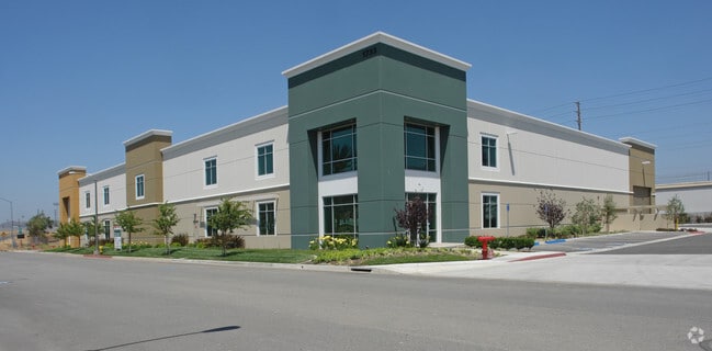

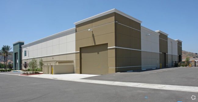

Property Detail
1733 W 2Nd St
8348-022-011
TR=61428 LOT 11
Warehouse
Los Angeles
POM1*
California
B and X Area of moderate flood hazard, usually the area between the limits of the 100-year and 500-year floods.
11
2025
0.83 AC
2025
East San Gabriel Valley
409000
Los Angeles
17,922 SF
Los Angeles-Long Beach-Glendale, CA
NEARBY LISTINGS FOR SALE OR LEASE
DEMOGRAPHICS near 1733 W 2Nd St
1 mile
3 mile
5 mile
2025 Total Population
21,467
129,798
344,986
2030 Population
21,248
128,761
343,225
Pop Growth 2025-2030
(1.02%)
(0.80%)
(0.51%)
Average Age
37
38
40
2025 Total Households
5,538
36,027
105,061
HH Growth 2025-2030
(1.26%)
(1.05%)
(0.69%)
Median Household Inc
$75,513
$83,095
$94,929
Avg Household Size
3.70
3.40
3.10
2025 Avg HH Vehicles
2.00
2.00
2.00
Median Home Value
$561,973
$689,932
$743,058
Median Year Built
1963
1970
1974
Nearby Places
Map Layers
Map Styles
 Street
 Aerial
Layers
 Traffic
 Biking
Places
Listings with unknown addresses are not visible on the map
- Restaurants
- Banks
- Shops
- Fitness
- Groceries
PUBLIC TRANSPORTATION
COMMUTER RAIL
Downtown Pomona (Riverside Line - Southern California Regional Rail Authority (Metrolink))
Drive
Walk
Distance
Downtown Pomona (Riverside Line - Southern California Regional Rail Authority (Metrolink))
6 min
2.2 mi
Pomona (North) (San Bernardino Line - Southern California Regional Rail Authority (Metrolink))
Drive
Walk
Distance
Pomona (North) (San Bernardino Line - Southern California Regional Rail Authority (Metrolink))
11 min
5.0 mi
AIRPORT
Ontario International
Drive
Walk
Distance
Ontario International
22 min
11.3 mi
John Wayne/Orange County
Drive
Walk
Distance
John Wayne/Orange County
41 min
32.3 mi
Long Beach (Daugherty Field)
Drive
Walk
Distance
Long Beach (Daugherty Field)
52 min
37.5 mi
Freight Ports
Port of Long Beach
Drive
Walk
Distance
Port of Long Beach
58 min
43.3 mi
SALE & LEASE HISTORY
LISTING DATE
SALE/LEASE

Sep 25, 2016
For Lease
Feb 06, 2020
For Sale
Aug 07, 2019
For Sale
Nearby Properties
Address
Land Use
TOTAL SIZE
Lot Size
Zoning
Address
Land Use
TOTAL SIZE
Lot Size
Zoning
369,745 SF
22.12 AC
LVO
Address
Land Use
TOTAL SIZE
Lot Size
Zoning
491,876 SF
22.46 AC
Address
Land Use
TOTAL SIZE
Lot Size
Zoning
749,184 SF
32.26 AC
POM1
Address
Land Use
TOTAL SIZE
Lot Size
Zoning
418,820 SF
4.42 AC
Address
Land Use
TOTAL SIZE
Lot Size
Zoning
172,108 SF
7.77 AC
POR31500S*
Address
Land Use
TOTAL SIZE
Lot Size
Zoning
271,974 SF
7.33 AC
POM2*
Address
Land Use
TOTAL SIZE
Lot Size
Zoning
176,482 SF
2.31 AC
POMU
Address
Land Use
TOTAL SIZE
Lot Size
Zoning
70,400 SF
11.04 AC
POM1*
Address
Land Use
TOTAL SIZE
Lot Size
Zoning
157,736 SF
8.14 AC
POC1
Address
Land Use
TOTAL SIZE
Lot Size
Zoning
272,258 SF
1.41 AC
POMU
Address
Land Use
TOTAL SIZE
Lot Size
Zoning
90,009 SF
6.22 AC
SDAP*
Address
Land Use
TOTAL SIZE
Lot Size
Zoning
378,980 SF
8.03 AC
POM2*
Address
Land Use
TOTAL SIZE
Lot Size
Zoning
95,267 SF
3.12 AC
POR17200-R
Address
Land Use
TOTAL SIZE
Lot Size
Zoning
355,816 SF
16.59 AC
POC4*
Address
Land Use
TOTAL SIZE
Lot Size
Zoning
155,697 SF
1.82 AC
POC3*
Address
Land Use
TOTAL SIZE
Lot Size
Zoning
280,624 SF
12.45 AC
POM2
Address
Land Use
TOTAL SIZE
Lot Size
Zoning
100,332 SF
10.13 AC
Address
Land Use
TOTAL SIZE
Lot Size
Zoning
201,940 SF
9.41 AC
POM2*
Address
Land Use
TOTAL SIZE
Lot Size
Zoning
99,456 SF
5.38 AC
LCA17000*
Address
Land Use
TOTAL SIZE
Lot Size
Zoning
238,268 SF
19.95 AC
POM1*
Address
Land Use
TOTAL SIZE
Lot Size
Zoning
95,109 SF
7.24 AC
LCCPD*
Address
Land Use
TOTAL SIZE
Lot Size
Zoning
72,707 SF
0.78 AC
POMUI*
Address
Land Use
TOTAL SIZE
Lot Size
Zoning
236,226 SF
9.88 AC
POM1*
Address
Land Use
TOTAL SIZE
Lot Size
Zoning
63,284 SF
3.27 AC
POM2*
Address
Land Use
TOTAL SIZE
Lot Size
Zoning
146,016 SF
7.08 AC
POM2*
Address
Land Use
TOTAL SIZE
Lot Size
Zoning
138,627 SF
10.32 AC
POR17200-R
Address
Land Use
TOTAL SIZE
Lot Size
Zoning
201,715 SF
4.53 AC
POM2*
Address
Land Use
TOTAL SIZE
Lot Size
Zoning
109,728 SF
5.57 AC
LCA17000*
Address
Land Use
TOTAL SIZE
Lot Size
Zoning
186,223 SF
1.58 AC
POC3*
Address
Land Use
TOTAL SIZE
Lot Size
Zoning
282,264 SF
13.55 AC
IDMA*
The World's #1 Commercial Real Estate Marketplace
Connect with us
© 2026 CoStar Group
The information above has been obtained from sources believed reliable. While we do not doubt its accuracy we have not verified it and make no guarantee, warranty or representation about it. It is your responsibility to independently confirm its accuracy and completeness. Any projections, opinions, assumptions, or estimates used are for example only and do not represent the current or future performance of the property. The value of this transaction to you depends on tax and other factors which should be evaluated by your tax, financial, and legal advisors. You and your advisors should conduct a careful, independent investigation of the property to determine to your satisfaction the suitability of the property for your needs.