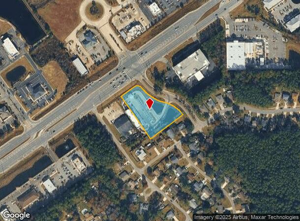
Property Record
1734 Blanding Blvd, Middleburg, FL 32068
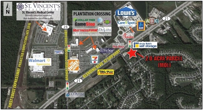
NEARBY LISTINGS FOR SALE OR LEASE
Property Detail
1734 Blanding Blvd
32-04-25-008101-040-57
Coppergate Unit 2A Replat 1
Servicestation
PT SW1/4 S32T4R25 AS REC OR 4014 PG 884
X
Clay
12019C0155E
Florida
2024
1.99 AC
2025
Orange Park/Clay County
030204
Jacksonville (Florida)
5,066 SF
Jacksonville, FL
DEMOGRAPHICS near 1734 Blanding Blvd
1 Mile
3 Mile
5 Mile
2024 Total Population
6,145
29,974
87,161
2029 Population
6,735
32,790
95,526
Pop Growth 2024-2029
+ 9.60%
+ 9.39%
+ 9.60%
Average Age
36
39
39
2024 Total Households
2,174
10,615
30,257
HH Growth 2024-2029
+ 9.52%
+ 9.39%
+ 9.60%
Median Household Inc
$73,580
$83,050
$84,545
Avg Household Size
2.80
2.80
2.80
2024 Avg HH Vehicles
2.00
2.00
2.00
Median Home Value
$215,574
$229,731
$259,498
Median Year Built
2001
1995
1999
Nearby Places
Map Layers
Map Styles
 Street
 Aerial
- Restaurants
- Banks
- Shops
- Fitness
- Groceries
PUBLIC TRANSPORTATION
AIRPORT
Jacksonville International
DRIVE
WALK
Distance
Jacksonville International
51 min
34.7 mi
Freight Ports
Jacksonville Port
DRIVE
WALK
Distance
Jacksonville Port
45 min
28.5 mi
SALE & LEASE HISTORY
LISTING DATE
SALE/LEASE

Mar 30, 2017
For Lease
Nearby Properties
Address
Land Use
TOTAL SIZE
Lot Size
Zoning
Address
Land Use
TOTAL SIZE
Lot Size
Zoning
340,385 SF
28.98 AC
Address
Land Use
TOTAL SIZE
Lot Size
Zoning
799,320 SF
150.55 AC
Address
Land Use
TOTAL SIZE
Lot Size
Zoning
241,396 SF
37.78 AC
Address
Land Use
TOTAL SIZE
Lot Size
Zoning
257,608 SF
27.17 AC
Address
Land Use
TOTAL SIZE
Lot Size
Zoning
233,551 SF
18.96 AC
PUD
Address
Land Use
TOTAL SIZE
Lot Size
Zoning
235,679 SF
53.26 AC
PO-1
Address
Land Use
TOTAL SIZE
Lot Size
Zoning
297,028 SF
16.78 AC
PUD
Address
Land Use
TOTAL SIZE
Lot Size
Zoning
83,621 SF
26.35 AC
Address
Land Use
TOTAL SIZE
Lot Size
Zoning
141,441 SF
82.05 AC
Address
Land Use
TOTAL SIZE
Lot Size
Zoning
105,657 SF
28.86 AC
Address
Land Use
TOTAL SIZE
Lot Size
Zoning
174,016 SF
8.12 AC
Address
Land Use
TOTAL SIZE
Lot Size
Zoning
106,486 SF
24.23 AC
PS-1
Address
Land Use
TOTAL SIZE
Lot Size
Zoning
67,490 SF
1.40 AC
Address
Land Use
TOTAL SIZE
Lot Size
Zoning
89,513 SF
19.76 AC
Address
Land Use
TOTAL SIZE
Lot Size
Zoning
221,247 SF
27.30 AC
Address
Land Use
TOTAL SIZE
Lot Size
Zoning
70,640 SF
7.15 AC
Address
Land Use
TOTAL SIZE
Lot Size
Zoning
113,473 SF
14.90 AC
Address
Land Use
TOTAL SIZE
Lot Size
Zoning
59,700 SF
0.58 AC
Address
Land Use
TOTAL SIZE
Lot Size
Zoning
140,280 SF
10.74 AC
Address
Land Use
TOTAL SIZE
Lot Size
Zoning
83,680 SF
7.86 AC
Address
Land Use
TOTAL SIZE
Lot Size
Zoning
60.13 AC
Address
Land Use
TOTAL SIZE
Lot Size
Zoning
110,457 SF
4.07 AC
BB
Address
Land Use
TOTAL SIZE
Lot Size
Zoning
101,582 SF
36.73 AC
Address
Land Use
TOTAL SIZE
Lot Size
Zoning
105,513 SF
3.55 AC
Address
Land Use
TOTAL SIZE
Lot Size
Zoning
29.98 AC
Address
Land Use
TOTAL SIZE
Lot Size
Zoning
125,604 SF
23.77 AC
Address
Land Use
TOTAL SIZE
Lot Size
Zoning
79,740 SF
26.99 AC
Address
Land Use
TOTAL SIZE
Lot Size
Zoning
92,250 SF
3.14 AC
Address
Land Use
TOTAL SIZE
Lot Size
Zoning
94,293 SF
40 AC
PS-1
Address
Land Use
TOTAL SIZE
Lot Size
Zoning
47,920 SF
3.50 AC
The World's #1 Commercial Real Estate Marketplace
Connect with us
© 2025 CoStar Group
The information above has been obtained from sources believed reliable. While we do not doubt its accuracy we have not verified it and make no guarantee, warranty or representation about it. It is your responsibility to independently confirm its accuracy and completeness. Any projections, opinions, assumptions, or estimates used are for example only and do not represent the current or future performance of the property. The value of this transaction to you depends on tax and other factors which should be evaluated by your tax, financial, and legal advisors. You and your advisors should conduct a careful, independent investigation of the property to determine to your satisfaction the suitability of the property for your needs.