Property Record
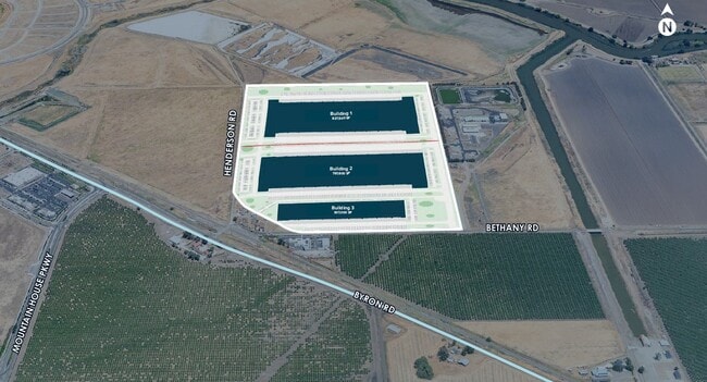
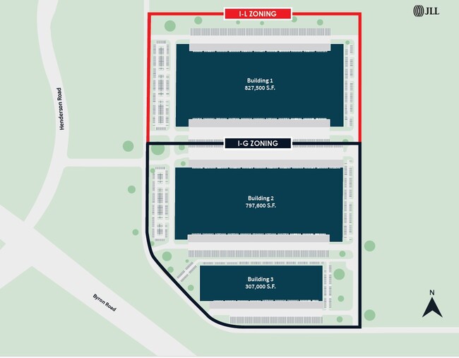
17353 W Bethany Rd, Tracy, CA 95391
This Property Is For Sale
Property Detail
17353 W Bethany Rd
209-160-12
02-FM PT OF 209-160-02/PT TO 12/14/15 PM 21-161
Industrialacreage
SAN JOAQUIN
IL
California
B and X Area of moderate flood hazard, usually the area between the limits of the 100-year and 500-year floods.
48.14 AC
2025
Tracy/Manteca
2025
Stockton/Modesto
005223
Stockton-Lodi, CA
NEARBY LISTINGS FOR SALE OR LEASE
DEMOGRAPHICS near 17353 W Bethany Rd
1 mile
3 mile
5 mile
2025 Total Population
1,368
31,270
58,050
2030 Population
1,473
33,418
61,337
Pop Growth 2025-2030
+ 7.68%
+ 6.87%
+ 5.66%
Average Age
35
34
36
2025 Total Households
354
8,774
16,417
HH Growth 2025-2030
+ 7.91%
+ 7.02%
+ 5.76%
Median Household Inc
$171,226
$176,297
$150,495
Avg Household Size
3.80
3.50
3.50
2025 Avg HH Vehicles
3.00
2.00
3.00
Median Home Value
$733,812
$858,142
$806,203
Median Year Built
2006
2010
2006
Nearby Places
Map Layers
Map Styles
 Street
 Aerial
Transit
 Traffic
 Biking
Places
Listings with unknown addresses are not visible on the map
- Restaurants
- Banks
- Shops
- Fitness
- Groceries
PUBLIC TRANSPORTATION
COMMUTER RAIL
Tracy Station (ACE Train - Altamont Corridor Express)
Drive
Walk
Distance
Tracy Station (ACE Train - Altamont Corridor Express)
17 min
9.4 mi
AIRPORT
Stockton Metro
Drive
Walk
Distance
Stockton Metro
33 min
24.5 mi
Freight Ports
Port of Stockton
Drive
Walk
Distance
Port of Stockton
36 min
27.8 mi
Nearby Properties
Address
Land Use
TOTAL SIZE
Lot Size
Zoning
Address
Land Use
TOTAL SIZE
Lot Size
Zoning
15.20 AC
RH
Address
Land Use
TOTAL SIZE
Lot Size
Zoning
407.40 AC
RL
Address
Land Use
TOTAL SIZE
Lot Size
Zoning
Address
Land Use
TOTAL SIZE
Lot Size
Zoning
960 SF
31.71 AC
RL
Address
Land Use
TOTAL SIZE
Lot Size
Zoning
148,645 SF
7.15 AC
IP
Address
Land Use
TOTAL SIZE
Lot Size
Zoning
249.59 AC
PF
Address
Land Use
TOTAL SIZE
Lot Size
Zoning
139,273 SF
7.34 AC
IP
Address
Land Use
TOTAL SIZE
Lot Size
Zoning
91,612 SF
6.20 AC
IP
Address
Land Use
TOTAL SIZE
Lot Size
Zoning
8.80 AC
RH
Address
Land Use
TOTAL SIZE
Lot Size
Zoning
80.44 AC
AG40
Address
Land Use
TOTAL SIZE
Lot Size
Zoning
82,567 SF
4.45 AC
IP
Address
Land Use
TOTAL SIZE
Lot Size
Zoning
1,320 SF
96.99 AC
AG40
Address
Land Use
TOTAL SIZE
Lot Size
Zoning
157.60 AC
AG40
Address
Land Use
TOTAL SIZE
Lot Size
Zoning
28,250 SF
1.95 AC
CO
Address
Land Use
TOTAL SIZE
Lot Size
Zoning
1,452 SF
39.73 AC
AG40
Address
Land Use
TOTAL SIZE
Lot Size
Zoning
13,500 SF
16.39 AC
AG40
Address
Land Use
TOTAL SIZE
Lot Size
Zoning
900 SF
1,171.28 AC
AG80
Address
Land Use
TOTAL SIZE
Lot Size
Zoning
55,545 SF
1.28 AC
Address
Land Use
TOTAL SIZE
Lot Size
Zoning
135.44 AC
IP
Address
Land Use
TOTAL SIZE
Lot Size
Zoning
5,126 SF
349 AC
Address
Land Use
TOTAL SIZE
Lot Size
Zoning
1.36 AC
Address
Land Use
TOTAL SIZE
Lot Size
Zoning
50,990 SF
2.59 AC
IP
Address
Land Use
TOTAL SIZE
Lot Size
Zoning
15.59 AC
Address
Land Use
TOTAL SIZE
Lot Size
Zoning
11,881 SF
1 AC
CN
The World's #1 Commercial Real Estate Marketplace
Connect with us
© 2026 CoStar Group
The information above has been obtained from sources believed reliable. While we do not doubt its accuracy we have not verified it and make no guarantee, warranty or representation about it. It is your responsibility to independently confirm its accuracy and completeness. Any projections, opinions, assumptions, or estimates used are for example only and do not represent the current or future performance of the property. The value of this transaction to you depends on tax and other factors which should be evaluated by your tax, financial, and legal advisors. You and your advisors should conduct a careful, independent investigation of the property to determine to your satisfaction the suitability of the property for your needs.