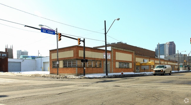
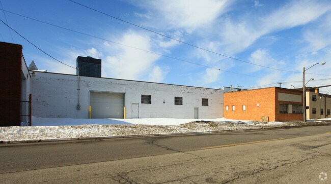
Property Record
1740 Saint Clair Ave Ne, Cleveland, OH 44114
NEARBY LISTINGS FOR SALE OR LEASE
Property Detail
1740 Saint Clair Ave Ne
Cleveland-Elyria, OH
H B Paynes
102-08-059
104 PAYNE 0002 NP
Officebuilding
Cuyahoga
X
Ohio
39035C0068F
2
2024
0.10 AC
2024
Downtown
107802
Cleveland
4,425 SF
DEMOGRAPHICS near 1740 Saint Clair Ave Ne
1 Mile
3 Mile
5 Mile
2024 Total Population
16,011
72,476
222,173
2029 Population
16,302
71,914
218,647
Pop Growth 2024-2029
+ 1.82%
(0.78%)
(1.59%)
Average Age
34
37
38
2024 Total Households
9,082
35,865
103,339
HH Growth 2024-2029
+ 2.94%
(0.42%)
(1.46%)
Median Household Inc
$51,014
$38,213
$33,102
Avg Household Size
1.50
1.80
2.00
2024 Avg HH Vehicles
1.00
1.00
1.00
Median Home Value
$135,333
$170,407
$89,814
Median Year Built
1968
1949
1947
Nearby Places
- Restaurants
- Banks
- Shops
- Fitness
- Groceries
PUBLIC TRANSPORTATION
TRANSIT/SUBWAY
North Coast Station (Blue/Green/Waterfront Lines - Greater Cleveland Regional Transit Authority)
DRIVE
WALK
Distance
North Coast Station (Blue/Green/Waterfront Lines - Greater Cleveland Regional Transit Authority)
6 min
18 min
0.9 mi
Tower City - Public Square (Blue Line - Greater Cleveland Regional Transit Authority Rapid Transit (The Rapid), Green Line - Greater Cleveland Regional Transit Authority Rapid Transit (The Rapid), Red Line - Greater Cleveland Regional Transit Authority Rapid Transit (The Rapid))
DRIVE
WALK
Distance
Tower City - Public Square (Blue Line - Greater Cleveland Regional Transit Authority Rapid Transit (The Rapid), Green Line - Greater Cleveland Regional Transit Authority Rapid Transit (The Rapid), Red Line - Greater Cleveland Regional Transit Authority Rapid Transit (The Rapid))
3 min
20 min
1.0 mi
COMMUTER RAIL
Cleveland Lakefront Station (Blue Line - Greater Cleveland Regional Transit Authority Rapid Transit (The Rapid), Green Line - Greater Cleveland Regional Transit Authority Rapid Transit (The Rapid))
DRIVE
WALK
Distance
Cleveland Lakefront Station (Blue Line - Greater Cleveland Regional Transit Authority Rapid Transit (The Rapid), Green Line - Greater Cleveland Regional Transit Authority Rapid Transit (The Rapid))
7 min
19 min
1.0 mi
Rockside (National Park Scenic Railway - Cuyahoga Valley Scenic Railroad)
DRIVE
WALK
Distance
Rockside (National Park Scenic Railway - Cuyahoga Valley Scenic Railroad)
17 min
9.6 mi
AIRPORT
Cleveland-Hopkins International
DRIVE
WALK
Distance
Cleveland-Hopkins International
23 min
14.1 mi
Freight Ports
Port of Toledo
DRIVE
WALK
Distance
Port of Toledo
137 min
114.5 mi
SALE & LEASE HISTORY
LISTING DATE
SALE/LEASE

Apr 06, 2022
For Lease
Nearby Properties
Address
Land Use
TOTAL SIZE
Lot Size
Zoning
Address
Land Use
TOTAL SIZE
Lot Size
Zoning
753,970 SF
9.31 AC
GR
Address
Land Use
TOTAL SIZE
Lot Size
Zoning
1,570,958 SF
1.33 AC
GR
Address
Land Use
TOTAL SIZE
Lot Size
Zoning
17.45 AC
GI
Address
Land Use
TOTAL SIZE
Lot Size
Zoning
16.78 AC
SI
Address
Land Use
TOTAL SIZE
Lot Size
Zoning
710,780 SF
4.33 AC
GR
Address
Land Use
TOTAL SIZE
Lot Size
Zoning
765,607 SF
12.15 AC
GR
Address
Land Use
TOTAL SIZE
Lot Size
Zoning
788,580 SF
4.85 AC
GR
Address
Land Use
TOTAL SIZE
Lot Size
Zoning
1,227,793 SF
6.80 AC
GR
Address
Land Use
TOTAL SIZE
Lot Size
Zoning
434,475 SF
0.53 AC
Address
Land Use
TOTAL SIZE
Lot Size
Zoning
1,191,268 SF
3.94 AC
SI
Address
Land Use
TOTAL SIZE
Lot Size
Zoning
6.98 AC
SI
Address
Land Use
TOTAL SIZE
Lot Size
Zoning
148,486 SF
489.21 AC
GI
Address
Land Use
TOTAL SIZE
Lot Size
Zoning
5,100 SF
9.41 AC
GI
Address
Land Use
TOTAL SIZE
Lot Size
Zoning
652,455 SF
2.04 AC
GR
Address
Land Use
TOTAL SIZE
Lot Size
Zoning
263,723 SF
7.48 AC
GI
Address
Land Use
TOTAL SIZE
Lot Size
Zoning
1,130,924 SF
4.02 AC
SI
Address
Land Use
TOTAL SIZE
Lot Size
Zoning
299,515 SF
1.30 AC
GR
Address
Land Use
TOTAL SIZE
Lot Size
Zoning
1,181,536 SF
27.82 AC
RO
Address
Land Use
TOTAL SIZE
Lot Size
Zoning
228,154 SF
0.48 AC
GR
Address
Land Use
TOTAL SIZE
Lot Size
Zoning
3.23 AC
LLR
Address
Land Use
TOTAL SIZE
Lot Size
Zoning
2.74 AC
Address
Land Use
TOTAL SIZE
Lot Size
Zoning
1,003,787 SF
2.12 AC
GR
Address
Land Use
TOTAL SIZE
Lot Size
Zoning
1,467,599 SF
1.66 AC
GR
Address
Land Use
TOTAL SIZE
Lot Size
Zoning
758,394 SF
2.25 AC
GR
Address
Land Use
TOTAL SIZE
Lot Size
Zoning
493,911 SF
1.88 AC
LLR
Address
Land Use
TOTAL SIZE
Lot Size
Zoning
1.53 AC
LLR
Address
Land Use
TOTAL SIZE
Lot Size
Zoning
299,507 SF
2.14 AC
LR
Address
Land Use
TOTAL SIZE
Lot Size
Zoning
194,478 SF
9.61 AC
SI
Address
Land Use
TOTAL SIZE
Lot Size
Zoning
2.83 AC
LLR
Address
Land Use
TOTAL SIZE
Lot Size
Zoning
723,254 SF
1.28 AC
SI
The World's #1 Commercial Real Estate Marketplace
Connect with us
© 2025 CoStar Group
The information above has been obtained from sources believed reliable. While we do not doubt its accuracy we have not verified it and make no guarantee, warranty or representation about it. It is your responsibility to independently confirm its accuracy and completeness. Any projections, opinions, assumptions, or estimates used are for example only and do not represent the current or future performance of the property. The value of this transaction to you depends on tax and other factors which should be evaluated by your tax, financial, and legal advisors. You and your advisors should conduct a careful, independent investigation of the property to determine to your satisfaction the suitability of the property for your needs.