Property Record
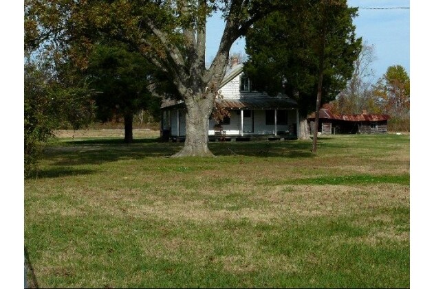
1736 Mount Pleasant Rd, Chesapeake, VA 23322
NEARBY LISTINGS FOR SALE OR LEASE
-
-
View all Chesapeake listings for sale on LoopNet.com
Property Detail
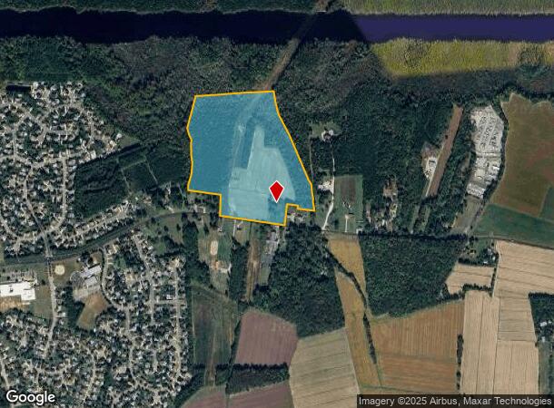
1736 Mount Pleasant Rd
Virginia Beach-Norfolk-Newport News, VA-NC
Whole Map 049, 050
0500000000550
BOUNDARY SURVEY CITY OF CHESAPEAKE PROP 54.253 AC
Taxexempt
Chesapeake
AE
Virginia
5155310160G
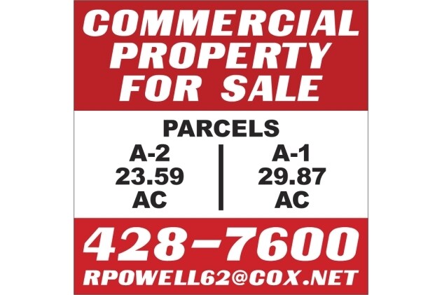
54.25 AC
0
Southern Chesapeake
2025
Hampton Roads
021103
DEMOGRAPHICS near 1736 Mount Pleasant Rd
1 Mile
3 Mile
5 Mile
2024 Total Population
2,066
18,108
108,444
2029 Population
2,115
18,607
109,668
Pop Growth 2024-2029
+ 2.37%
+ 2.76%
+ 1.13%
Average Age
39
40
39
2024 Total Households
650
5,978
38,644
HH Growth 2024-2029
+ 2.62%
+ 2.89%
+ 1.28%
Median Household Inc
$142,382
$136,247
$106,519
Avg Household Size
3.10
3.00
2.70
2024 Avg HH Vehicles
3.00
3.00
2.00
Median Home Value
$461,270
$431,022
$356,654
Median Year Built
1996
1994
1990
Nearby Places
Map Layers
Map Styles
 Street
 Aerial
- Restaurants
- Banks
- Shops
- Fitness
- Groceries
PUBLIC TRANSPORTATION
AIRPORT
Norfolk International
DRIVE
WALK
Distance
Norfolk International
30 min
20.0 mi
Freight Ports
Virginia Port Authority - Portsmouth
DRIVE
WALK
Distance
Virginia Port Authority - Portsmouth
29 min
19.0 mi
Nearby Properties
Address
Land Use
TOTAL SIZE
Lot Size
Zoning
Address
Land Use
TOTAL SIZE
Lot Size
Zoning
2,592.19 AC
A1: AGRICU
Address
Land Use
TOTAL SIZE
Lot Size
Zoning
422.43 AC
PUD: PLANN
Address
Land Use
TOTAL SIZE
Lot Size
Zoning
269.85 AC
MULTI: MUL
Address
Land Use
TOTAL SIZE
Lot Size
Zoning
35,962 SF
15.91 AC
B2: GENERA
Address
Land Use
TOTAL SIZE
Lot Size
Zoning
88,567 SF
15 AC
R15S: RESI
Address
Land Use
TOTAL SIZE
Lot Size
Zoning
66,978 SF
14.61 AC
RMF1: MULT
Address
Land Use
TOTAL SIZE
Lot Size
Zoning
40,337 SF
23.62 AC
AC: ASSEMB
Address
Land Use
TOTAL SIZE
Lot Size
Zoning
24,004 SF
13.56 AC
R15S: RESI
Address
Land Use
TOTAL SIZE
Lot Size
Zoning
13,915 SF
5.46 AC
O-I: OFFIC
Address
Land Use
TOTAL SIZE
Lot Size
Zoning
64,829 SF
16.33 AC
R15S: RESI
Address
Land Use
TOTAL SIZE
Lot Size
Zoning
98.44 AC
R10S: RESI
Address
Land Use
TOTAL SIZE
Lot Size
Zoning
8.26 AC
A1: AGRICU
Address
Land Use
TOTAL SIZE
Lot Size
Zoning
20,770 SF
12.05 AC
AC: ASSEMB
Address
Land Use
TOTAL SIZE
Lot Size
Zoning
39.91 AC
PUD: PLANN
Address
Land Use
TOTAL SIZE
Lot Size
Zoning
40,068 SF
11.98 AC
R15S: RESI
Address
Land Use
TOTAL SIZE
Lot Size
Zoning
11,171 SF
31.44 AC
M2: GENERA
Address
Land Use
TOTAL SIZE
Lot Size
Zoning
46,564 SF
5.51 AC
B2: GENERA
Address
Land Use
TOTAL SIZE
Lot Size
Zoning
115 AC
MULTI: MUL
Address
Land Use
TOTAL SIZE
Lot Size
Zoning
1,680 SF
18.91 AC
M1: LIGHT
Address
Land Use
TOTAL SIZE
Lot Size
Zoning
5,160 SF
5.93 AC
PUD: PLANN
Address
Land Use
TOTAL SIZE
Lot Size
Zoning
18,939 SF
2.84 AC
B2: GENERA
Address
Land Use
TOTAL SIZE
Lot Size
Zoning
18,135 SF
6.69 AC
B2: GENERA
Address
Land Use
TOTAL SIZE
Lot Size
Zoning
39,868 SF
3.78 AC
B1: NEIGHB
Address
Land Use
TOTAL SIZE
Lot Size
Zoning
20,539 SF
12 AC
A1: AGRICU
Address
Land Use
TOTAL SIZE
Lot Size
Zoning
22,165 SF
5.95 AC
PUD: PLANN
Address
Land Use
TOTAL SIZE
Lot Size
Zoning
15,488 SF
4.97 AC
B2: GENERA
Address
Land Use
TOTAL SIZE
Lot Size
Zoning
20 AC
R15AS: RES
Address
Land Use
TOTAL SIZE
Lot Size
Zoning
18,575 SF
3.59 AC
PUD: PLANN
Address
Land Use
TOTAL SIZE
Lot Size
Zoning
14,563 SF
1.71 AC
B2: GENERA
Address
Land Use
TOTAL SIZE
Lot Size
Zoning
912 SF
249.03 AC
A1: AGRICU
The World's #1 Commercial Real Estate Marketplace
Connect with us
© 2025 CoStar Group
The information above has been obtained from sources believed reliable. While we do not doubt its accuracy we have not verified it and make no guarantee, warranty or representation about it. It is your responsibility to independently confirm its accuracy and completeness. Any projections, opinions, assumptions, or estimates used are for example only and do not represent the current or future performance of the property. The value of this transaction to you depends on tax and other factors which should be evaluated by your tax, financial, and legal advisors. You and your advisors should conduct a careful, independent investigation of the property to determine to your satisfaction the suitability of the property for your needs.