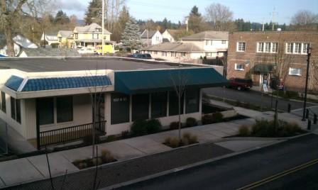
Property Record
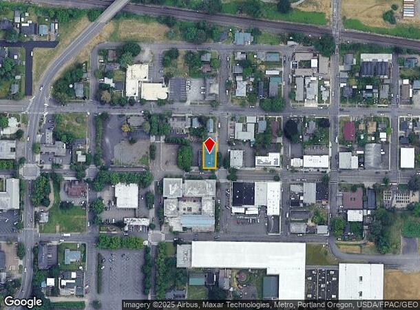
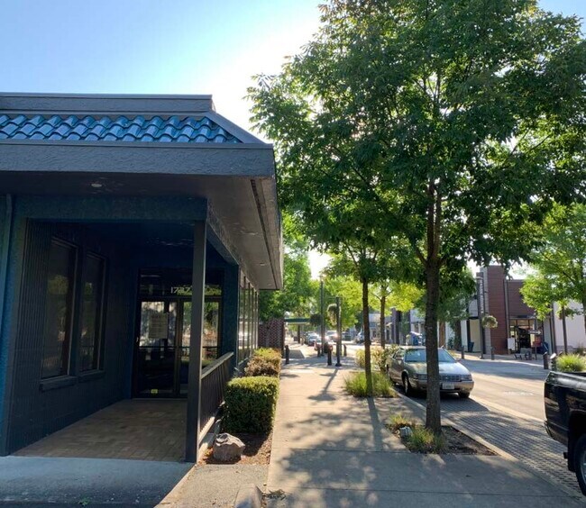
1737 Main St, Washougal, WA 98671

NEARBY LISTINGS FOR SALE OR LEASE
-
-
View all Washougal listings for lease on LoopNet.com
Property Detail
1737 Main St
Portland-Vancouver-Hillsboro, OR-WA
Washougal
073760-000
WASHOUGAL LOT 8 BLK 9 FOR ASSESSOR USE ONLY WASHOUGAL LOT 8 BLK 9
Officebuilding
Clark
X
Washington
41051C0228J
8
2025
0.12 AC
2025
Camas/Washougal
040509
Portland
1,922 SF
DEMOGRAPHICS near 1737 Main St
1 Mile
3 Mile
5 Mile
2024 Total Population
7,323
26,092
73,352
2029 Population
7,869
28,130
76,353
Pop Growth 2024-2029
+ 7.46%
+ 7.81%
+ 4.09%
Average Age
41
40
40
2024 Total Households
2,858
9,561
25,710
HH Growth 2024-2029
+ 7.56%
+ 7.91%
+ 4.05%
Median Household Inc
$81,887
$94,868
$96,239
Avg Household Size
2.60
2.70
2.80
2024 Avg HH Vehicles
2.00
2.00
2.00
Median Home Value
$442,125
$489,782
$476,596
Median Year Built
1979
1995
1992
Nearby Places
Map Layers
Map Styles
 Street
 Aerial
- Restaurants
- Banks
- Shops
- Fitness
- Groceries
PUBLIC TRANSPORTATION
AIRPORT
Portland International
DRIVE
WALK
Distance
Portland International
25 min
15.6 mi
SALE & LEASE HISTORY
LISTING DATE
SALE/LEASE

Nov 04, 2019
For Lease
Mar 30, 2023
For Lease
Nearby Properties
Address
Land Use
TOTAL SIZE
Lot Size
Zoning
Address
Land Use
TOTAL SIZE
Lot Size
Zoning
1,500,000 SF
189.27 AC
HI
Address
Land Use
TOTAL SIZE
Lot Size
Zoning
Address
Land Use
TOTAL SIZE
Lot Size
Zoning
478,472 SF
77.86 AC
GI
Address
Land Use
TOTAL SIZE
Lot Size
Zoning
857,470 SF
73.72 AC
GI
Address
Land Use
TOTAL SIZE
Lot Size
Zoning
262,320 SF
25.24 AC
IP
Address
Land Use
TOTAL SIZE
Lot Size
Zoning
14,059 SF
12.83 AC
GI
Address
Land Use
TOTAL SIZE
Lot Size
Zoning
224,500 SF
12.30 AC
R-7.5
Address
Land Use
TOTAL SIZE
Lot Size
Zoning
123,157 SF
24.23 AC
GR 5
Address
Land Use
TOTAL SIZE
Lot Size
Zoning
114,696 SF
2.29 AC
MF-18
Address
Land Use
TOTAL SIZE
Lot Size
Zoning
142,571 SF
1.73 AC
TC-C
Address
Land Use
TOTAL SIZE
Lot Size
Zoning
65,604 SF
11.35 AC
R-7.5
Address
Land Use
TOTAL SIZE
Lot Size
Zoning
Address
Land Use
TOTAL SIZE
Lot Size
Zoning
4,490 SF
75.54 AC
GI
Address
Land Use
TOTAL SIZE
Lot Size
Zoning
85,150 SF
16.32 AC
R-7.5
Address
Land Use
TOTAL SIZE
Lot Size
Zoning
83,139 SF
7.36 AC
HI
Address
Land Use
TOTAL SIZE
Lot Size
Zoning
256,888 SF
18.91 AC
TC-C
Address
Land Use
TOTAL SIZE
Lot Size
Zoning
108,108 SF
5.35 AC
IP
Address
Land Use
TOTAL SIZE
Lot Size
Zoning
64,400 SF
3.30 AC
MF-18
Address
Land Use
TOTAL SIZE
Lot Size
Zoning
10,000 SF
13.63 AC
R-7.5
Address
Land Use
TOTAL SIZE
Lot Size
Zoning
75,360 SF
4.46 AC
RC
Address
Land Use
TOTAL SIZE
Lot Size
Zoning
51,600 SF
2.35 AC
AR-16
Address
Land Use
TOTAL SIZE
Lot Size
Zoning
68,130 SF
9.19 AC
R-7.5
Address
Land Use
TOTAL SIZE
Lot Size
Zoning
18,368 SF
21.40 AC
GI
Address
Land Use
TOTAL SIZE
Lot Size
Zoning
56,376 SF
4.04 AC
CC
Address
Land Use
TOTAL SIZE
Lot Size
Zoning
69,043 SF
0.92 AC
TC-C
Address
Land Use
TOTAL SIZE
Lot Size
Zoning
661.52 AC
GSO
Address
Land Use
TOTAL SIZE
Lot Size
Zoning
49,500 SF
6.48 AC
HI
Address
Land Use
TOTAL SIZE
Lot Size
Zoning
53,663 SF
3.40 AC
CH
Address
Land Use
TOTAL SIZE
Lot Size
Zoning
97,260 SF
4.70 AC
CH
The World's #1 Commercial Real Estate Marketplace
Connect with us
© 2025 CoStar Group
The information above has been obtained from sources believed reliable. While we do not doubt its accuracy we have not verified it and make no guarantee, warranty or representation about it. It is your responsibility to independently confirm its accuracy and completeness. Any projections, opinions, assumptions, or estimates used are for example only and do not represent the current or future performance of the property. The value of this transaction to you depends on tax and other factors which should be evaluated by your tax, financial, and legal advisors. You and your advisors should conduct a careful, independent investigation of the property to determine to your satisfaction the suitability of the property for your needs.