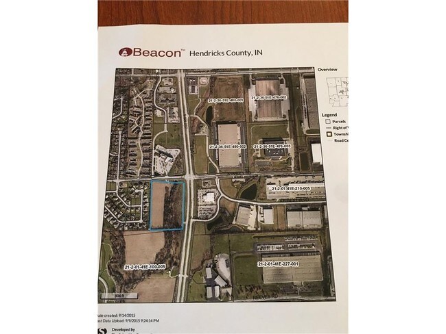
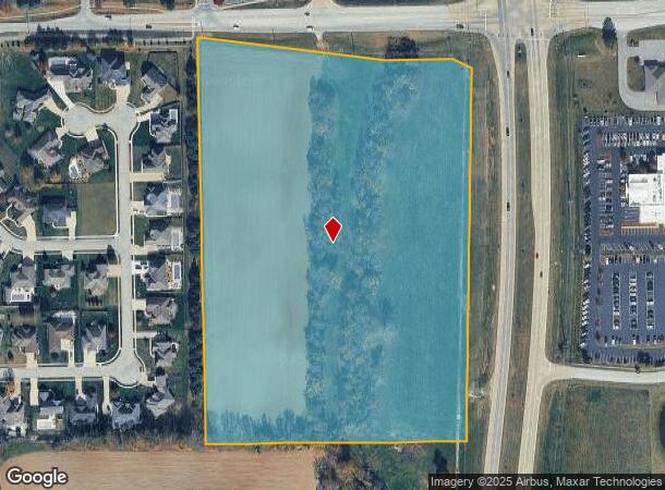
Property Record
1737 Stanley Rd, Plainfield, IN 46168
NEARBY LISTINGS FOR SALE OR LEASE
Property Detail
1737 Stanley Rd
32-15-01-100-002.000-012
PT N NW 1-14-1E 17.62AC
Agriculturalland
Hendricks
A
Indiana
18097C0205F
17.62 AC
2024
Hendricks County
2024
Indianapolis
210802
Indianapolis-Carmel-Anderson, IN
DEMOGRAPHICS near 1737 Stanley Rd
1 Mile
3 Mile
5 Mile
2024 Total Population
4,438
33,288
78,624
2029 Population
4,966
37,194
85,600
Pop Growth 2024-2029
+ 11.90%
+ 11.73%
+ 8.87%
Average Age
40
39
38
2024 Total Households
1,865
12,362
28,466
HH Growth 2024-2029
+ 11.96%
+ 11.90%
+ 9.06%
Median Household Inc
$70,451
$74,723
$80,162
Avg Household Size
2.30
2.40
2.60
2024 Avg HH Vehicles
2.00
2.00
2.00
Median Home Value
$209,880
$229,664
$221,751
Median Year Built
1978
1990
1996
Nearby Places
Map Layers
Map Styles
 Street
 Aerial
- Restaurants
- Banks
- Shops
- Fitness
- Groceries
PUBLIC TRANSPORTATION
AIRPORT
Indianapolis International
DRIVE
WALK
Distance
Indianapolis International
13 min
7.1 mi
Freight Ports
Port of Toledo
DRIVE
WALK
Distance
Port of Toledo
292 min
242.0 mi
SALE & LEASE HISTORY
LISTING DATE
SALE/LEASE

Apr 05, 2017
For Sale
Apr 03, 2017
For Sale
Nearby Properties
Address
Land Use
TOTAL SIZE
Lot Size
Zoning
Address
Land Use
TOTAL SIZE
Lot Size
Zoning
796,988 SF
48.51 AC
Address
Land Use
TOTAL SIZE
Lot Size
Zoning
950,625 SF
58.11 AC
Address
Land Use
TOTAL SIZE
Lot Size
Zoning
41.50 AC
Address
Land Use
TOTAL SIZE
Lot Size
Zoning
923,980 SF
60.08 AC
Address
Land Use
TOTAL SIZE
Lot Size
Zoning
811,536 SF
42.04 AC
Address
Land Use
TOTAL SIZE
Lot Size
Zoning
822,500 SF
45.66 AC
Address
Land Use
TOTAL SIZE
Lot Size
Zoning
9,728 SF
23.10 AC
Address
Land Use
TOTAL SIZE
Lot Size
Zoning
813,054 SF
45.32 AC
Address
Land Use
TOTAL SIZE
Lot Size
Zoning
770,712 SF
56.53 AC
Address
Land Use
TOTAL SIZE
Lot Size
Zoning
799,264 SF
43.44 AC
Address
Land Use
TOTAL SIZE
Lot Size
Zoning
629,200 SF
39.74 AC
Address
Land Use
TOTAL SIZE
Lot Size
Zoning
702,000 SF
42.11 AC
Address
Land Use
TOTAL SIZE
Lot Size
Zoning
702,000 SF
36.88 AC
Address
Land Use
TOTAL SIZE
Lot Size
Zoning
5,064 SF
25.50 AC
Address
Land Use
TOTAL SIZE
Lot Size
Zoning
750,820 SF
64.15 AC
Address
Land Use
TOTAL SIZE
Lot Size
Zoning
747,256 SF
41.32 AC
Address
Land Use
TOTAL SIZE
Lot Size
Zoning
720,000 SF
39.03 AC
Address
Land Use
TOTAL SIZE
Lot Size
Zoning
595,938 SF
35.31 AC
Address
Land Use
TOTAL SIZE
Lot Size
Zoning
51,884 SF
14.73 AC
Address
Land Use
TOTAL SIZE
Lot Size
Zoning
650,960 SF
31.95 AC
Address
Land Use
TOTAL SIZE
Lot Size
Zoning
651,610 SF
63.52 AC
Address
Land Use
TOTAL SIZE
Lot Size
Zoning
292,315 SF
28.97 AC
Address
Land Use
TOTAL SIZE
Lot Size
Zoning
635,585 SF
28.37 AC
Address
Land Use
TOTAL SIZE
Lot Size
Zoning
24.62 AC
Address
Land Use
TOTAL SIZE
Lot Size
Zoning
10,953 SF
18.52 AC
Address
Land Use
TOTAL SIZE
Lot Size
Zoning
518,536 SF
25.66 AC
Address
Land Use
TOTAL SIZE
Lot Size
Zoning
37.04 AC
Address
Land Use
TOTAL SIZE
Lot Size
Zoning
551,424 SF
31.39 AC
Address
Land Use
TOTAL SIZE
Lot Size
Zoning
599,744 SF
34.65 AC
Address
Land Use
TOTAL SIZE
Lot Size
Zoning
500,192 SF
33.15 AC
The World's #1 Commercial Real Estate Marketplace
Connect with us
© 2025 CoStar Group
The information above has been obtained from sources believed reliable. While we do not doubt its accuracy we have not verified it and make no guarantee, warranty or representation about it. It is your responsibility to independently confirm its accuracy and completeness. Any projections, opinions, assumptions, or estimates used are for example only and do not represent the current or future performance of the property. The value of this transaction to you depends on tax and other factors which should be evaluated by your tax, financial, and legal advisors. You and your advisors should conduct a careful, independent investigation of the property to determine to your satisfaction the suitability of the property for your needs.