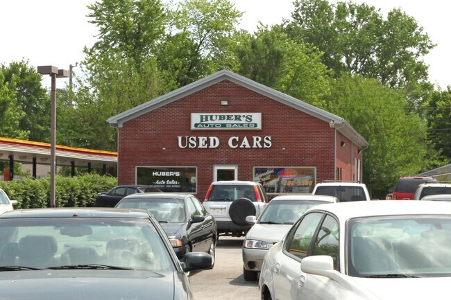
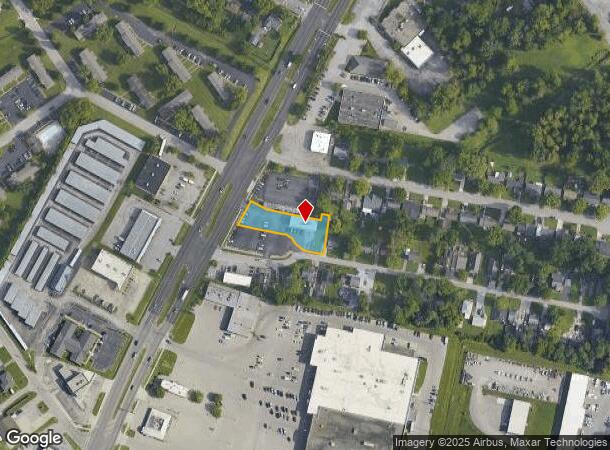
Property Record
1738 E 10Th St E, Jeffersonville, IN 47130
NEARBY LISTINGS FOR SALE OR LEASE
Property Detail
1738 E 10Th St E
10-20-01-000-008.000-010
AVONDALE CT REM. OF LOT 1 & 6
Commercialnec
Clark
X
Indiana
18019C0286E
1,6
2024
0.46 AC
2024
South Clark County
050304
Louisville
2,542 SF
Louisville-Jefferson County, KY-IN
DEMOGRAPHICS near 1738 E 10Th St E
1 Mile
3 Mile
5 Mile
2024 Total Population
8,886
61,272
170,186
2029 Population
9,441
65,011
175,377
Pop Growth 2024-2029
+ 6.25%
+ 6.10%
+ 3.05%
Average Age
38
40
41
2024 Total Households
3,760
26,740
76,423
HH Growth 2024-2029
+ 6.22%
+ 6.12%
+ 2.95%
Median Household Inc
$47,612
$53,916
$53,829
Avg Household Size
2.30
2.20
2.10
2024 Avg HH Vehicles
2.00
2.00
2.00
Median Home Value
$149,607
$162,592
$197,287
Median Year Built
1970
1974
1966
Nearby Places
Map Layers
Map Styles
 Street
 Aerial
- Restaurants
- Banks
- Shops
- Fitness
- Groceries
PUBLIC TRANSPORTATION
AIRPORT
Louisville Muhammad Ali International
DRIVE
WALK
Distance
Louisville Muhammad Ali International
22 min
11.9 mi
Nearby Properties
Address
Land Use
TOTAL SIZE
Lot Size
Zoning
Address
Land Use
TOTAL SIZE
Lot Size
Zoning
13,240 SF
20.84 AC
Address
Land Use
TOTAL SIZE
Lot Size
Zoning
2.07 AC
Address
Land Use
TOTAL SIZE
Lot Size
Zoning
4,361 SF
18.18 AC
Address
Land Use
TOTAL SIZE
Lot Size
Zoning
400 SF
13.92 AC
R6-RESIDEN
Address
Land Use
TOTAL SIZE
Lot Size
Zoning
4,402 SF
9.99 AC
Address
Land Use
TOTAL SIZE
Lot Size
Zoning
79,039 SF
26.39 AC
Address
Land Use
TOTAL SIZE
Lot Size
Zoning
15.29 AC
Address
Land Use
TOTAL SIZE
Lot Size
Zoning
2.81 AC
Address
Land Use
TOTAL SIZE
Lot Size
Zoning
176,448 SF
2.45 AC
Address
Land Use
TOTAL SIZE
Lot Size
Zoning
109,470 SF
2.27 AC
Address
Land Use
TOTAL SIZE
Lot Size
Zoning
4,178 SF
10.39 AC
Address
Land Use
TOTAL SIZE
Lot Size
Zoning
Address
Land Use
TOTAL SIZE
Lot Size
Zoning
Address
Land Use
TOTAL SIZE
Lot Size
Zoning
14,720 SF
13 AC
Address
Land Use
TOTAL SIZE
Lot Size
Zoning
120,337 SF
18.20 AC
Address
Land Use
TOTAL SIZE
Lot Size
Zoning
8,752 SF
19.78 AC
Address
Land Use
TOTAL SIZE
Lot Size
Zoning
534,140 SF
33 AC
Address
Land Use
TOTAL SIZE
Lot Size
Zoning
16,221 SF
2.40 AC
Address
Land Use
TOTAL SIZE
Lot Size
Zoning
303,047 SF
7.21 AC
Address
Land Use
TOTAL SIZE
Lot Size
Zoning
2,208 SF
26.20 AC
Address
Land Use
TOTAL SIZE
Lot Size
Zoning
11,404 SF
19.68 AC
Address
Land Use
TOTAL SIZE
Lot Size
Zoning
2,000 SF
13.11 AC
Address
Land Use
TOTAL SIZE
Lot Size
Zoning
136,949 SF
36.89 AC
Address
Land Use
TOTAL SIZE
Lot Size
Zoning
128,269 SF
10.18 AC
Address
Land Use
TOTAL SIZE
Lot Size
Zoning
17,520 SF
12.62 AC
Address
Land Use
TOTAL SIZE
Lot Size
Zoning
56,775 SF
5.30 AC
Address
Land Use
TOTAL SIZE
Lot Size
Zoning
12,752 SF
13.56 AC
Address
Land Use
TOTAL SIZE
Lot Size
Zoning
1,276 SF
3.78 AC
Address
Land Use
TOTAL SIZE
Lot Size
Zoning
75,560 SF
8.18 AC
Address
Land Use
TOTAL SIZE
Lot Size
Zoning
173,121 SF
15.82 AC
The World's #1 Commercial Real Estate Marketplace
Connect with us
© 2025 CoStar Group
The information above has been obtained from sources believed reliable. While we do not doubt its accuracy we have not verified it and make no guarantee, warranty or representation about it. It is your responsibility to independently confirm its accuracy and completeness. Any projections, opinions, assumptions, or estimates used are for example only and do not represent the current or future performance of the property. The value of this transaction to you depends on tax and other factors which should be evaluated by your tax, financial, and legal advisors. You and your advisors should conduct a careful, independent investigation of the property to determine to your satisfaction the suitability of the property for your needs.