Property Record
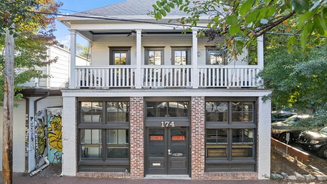
174 Carroll St Se, Atlanta, GA 30312


Current Lease Availabilities
NEARBY LISTINGS FOR SALE OR LEASE
Property Detail
174 Carroll St Se
Atlanta-Sandy Springs-Roswell, GA
Gravel Park
14-0020-0004-022-7
OFFICE BUILDING WITH GRAVEL PARKING KA: OFFICE BLDG 8/21 FC: VERIFIED USE 8/21
Officebuilding
Fulton
X
Georgia
13121C0376G
20
2024
0.17 AC
2025
Downtown Atlanta
003200
Atlanta
3,136 SF
DEMOGRAPHICS near 174 Carroll St Se
1 Mile
3 Mile
5 Mile
2024 Total Population
26,539
194,360
387,143
2029 Population
27,658
201,279
399,101
Pop Growth 2024-2029
+ 4.22%
+ 3.56%
+ 3.09%
Average Age
35
36
36
2024 Total Households
14,035
90,903
176,321
HH Growth 2024-2029
+ 4.68%
+ 3.92%
+ 3.37%
Median Household Inc
$94,835
$85,794
$78,832
Avg Household Size
1.70
1.80
2.00
2024 Avg HH Vehicles
1.00
1.00
1.00
Median Home Value
$531,836
$468,604
$442,241
Median Year Built
2000
1995
1987
Nearby Places
- Restaurants
- Banks
- Shops
- Fitness
- Groceries
PUBLIC TRANSPORTATION
TRANSIT/SUBWAY
King Memorial (Blue Line - Metropolitan Atlanta Rapid Transit Authority (MARTA), Green Line - Metropolitan Atlanta Rapid Transit Authority (MARTA))
DRIVE
WALK
Distance
King Memorial (Blue Line - Metropolitan Atlanta Rapid Transit Authority (MARTA), Green Line - Metropolitan Atlanta Rapid Transit Authority (MARTA))
3 min
18 min
1.0 mi
AIRPORT
Hartsfield - Jackson Atlanta International
DRIVE
WALK
Distance
Hartsfield - Jackson Atlanta International
14 min
10.5 mi
Freight Ports
Georgia Ports - Savannah
DRIVE
WALK
Distance
Georgia Ports - Savannah
1 min
217.9 mi
Nearby Properties
Address
Land Use
TOTAL SIZE
Lot Size
Zoning
Address
Land Use
TOTAL SIZE
Lot Size
Zoning
19.94 AC
SPI1
Address
Land Use
TOTAL SIZE
Lot Size
Zoning
1,585,451 SF
1.97 AC
SPI2
Address
Land Use
TOTAL SIZE
Lot Size
Zoning
2,283,599 SF
12.93 AC
I1
Address
Land Use
TOTAL SIZE
Lot Size
Zoning
9.80 AC
C5
Address
Land Use
TOTAL SIZE
Lot Size
Zoning
179.40 AC
R4
Address
Land Use
TOTAL SIZE
Lot Size
Zoning
3.16 AC
SPI1
Address
Land Use
TOTAL SIZE
Lot Size
Zoning
9 AC
C5
Address
Land Use
TOTAL SIZE
Lot Size
Zoning
10.27 AC
C5
Address
Land Use
TOTAL SIZE
Lot Size
Zoning
1,039,831 SF
0.31 AC
C4
Address
Land Use
TOTAL SIZE
Lot Size
Zoning
1,227,912 SF
2.15 AC
SPI4
Address
Land Use
TOTAL SIZE
Lot Size
Zoning
1,736,017 SF
3.63 AC
SPI2
Address
Land Use
TOTAL SIZE
Lot Size
Zoning
1,300,309 SF
4.81 AC
SPI1
Address
Land Use
TOTAL SIZE
Lot Size
Zoning
1,434,872 SF
1.89 AC
SPI1
Address
Land Use
TOTAL SIZE
Lot Size
Zoning
61.57 AC
C5
Address
Land Use
TOTAL SIZE
Lot Size
Zoning
1,116,157 SF
1.48 AC
SPI3
Address
Land Use
TOTAL SIZE
Lot Size
Zoning
1,467,469 SF
0.07 AC
C4
Address
Land Use
TOTAL SIZE
Lot Size
Zoning
10,954,869 SF
28.88 AC
C3
Address
Land Use
TOTAL SIZE
Lot Size
Zoning
1.55 AC
SPI1
Address
Land Use
TOTAL SIZE
Lot Size
Zoning
1,646,011 SF
3.74 AC
SPI4
Address
Land Use
TOTAL SIZE
Lot Size
Zoning
7 AC
C3
Address
Land Use
TOTAL SIZE
Lot Size
Zoning
342,275 SF
0.70 AC
SPI3
Address
Land Use
TOTAL SIZE
Lot Size
Zoning
467,847 SF
1.62 AC
I2
Address
Land Use
TOTAL SIZE
Lot Size
Zoning
1,314,183 SF
2.61 AC
SPI1
Address
Land Use
TOTAL SIZE
Lot Size
Zoning
2,577,342 SF
2.04 AC
SPI1
Address
Land Use
TOTAL SIZE
Lot Size
Zoning
1,356,182 SF
2.52 AC
SPI4
Address
Land Use
TOTAL SIZE
Lot Size
Zoning
1,121,700 SF
2.21 AC
I2
Address
Land Use
TOTAL SIZE
Lot Size
Zoning
13,340,229 SF
3.68 AC
SPI1
Address
Land Use
TOTAL SIZE
Lot Size
Zoning
415,551 SF
1.13 AC
C4
Address
Land Use
TOTAL SIZE
Lot Size
Zoning
7,420 SF
0.13 AC
RG6
Address
Land Use
TOTAL SIZE
Lot Size
Zoning
899,982 SF
2.91 AC
C4
The World's #1 Commercial Real Estate Marketplace
Connect with us
© 2025 CoStar Group
The information above has been obtained from sources believed reliable. While we do not doubt its accuracy we have not verified it and make no guarantee, warranty or representation about it. It is your responsibility to independently confirm its accuracy and completeness. Any projections, opinions, assumptions, or estimates used are for example only and do not represent the current or future performance of the property. The value of this transaction to you depends on tax and other factors which should be evaluated by your tax, financial, and legal advisors. You and your advisors should conduct a careful, independent investigation of the property to determine to your satisfaction the suitability of the property for your needs.