Property Record
174 Middlesex Tpke, Bedford, MA 01730
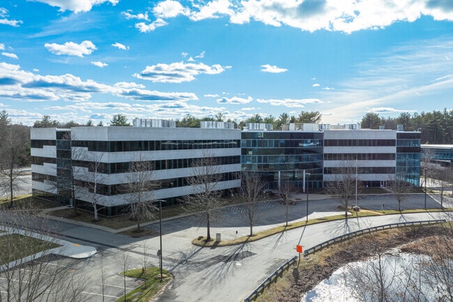

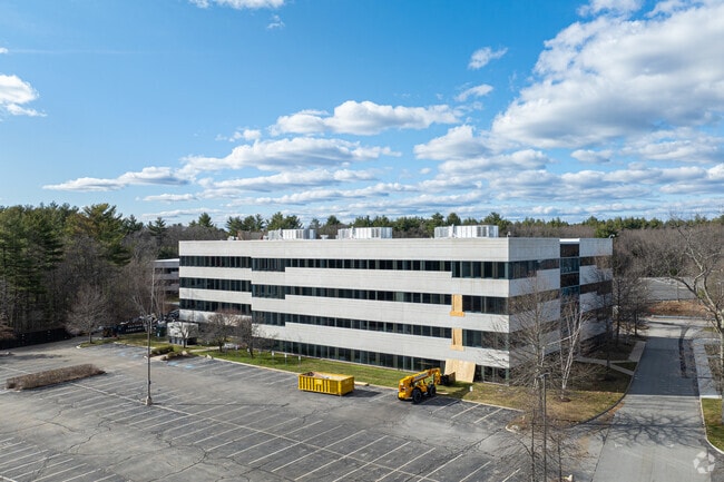

Property Detail
174 Middlesex Tpke
Officebuilding
MIDDLESEX
COM
Massachusetts
B and X Area of moderate flood hazard, usually the area between the limits of the 100-year and 500-year floods.
32.31 AC
2025
Lowell/Chelmsford
2025
Boston
359100
Boston-Cambridge-Newton, MA-NH
188,042 SF
BEDF-000012-000000-000017-000003
NEARBY LISTINGS FOR SALE OR LEASE
DEMOGRAPHICS near 174 Middlesex Tpke
1 mile
3 mile
5 mile
2025 Total Population
2,836
49,258
129,815
2030 Population
2,991
51,167
134,955
Pop Growth 2025-2030
+ 5.47%
+ 3.88%
+ 3.96%
Average Age
43
43
42
2025 Total Households
1,119
17,791
46,856
HH Growth 2025-2030
+ 5.90%
+ 4.02%
+ 4.11%
Median Household Inc
$141,236
$143,428
$147,905
Avg Household Size
2.40
2.70
2.70
2025 Avg HH Vehicles
2.00
2.00
2.00
Median Home Value
$756,322
$748,671
$760,957
Median Year Built
1992
1971
1972
Nearby Places
Map Layers
Map Styles
 Street
 Aerial
Transit
 Traffic
 Biking
Places
Listings with unknown addresses are not visible on the map
- Restaurants
- Banks
- Shops
- Fitness
- Groceries
PUBLIC TRANSPORTATION
COMMUTER RAIL
North Billerica (Lowell Line - Massachusetts Bay Transportation Authority Commuter Rail (Purple Line))
Drive
Walk
Distance
North Billerica (Lowell Line - Massachusetts Bay Transportation Authority Commuter Rail (Purple Line))
14 min
5.9 mi
Wilmington (Lowell Line - Massachusetts Bay Transportation Authority Commuter Rail (Purple Line))
Drive
Walk
Distance
Wilmington (Lowell Line - Massachusetts Bay Transportation Authority Commuter Rail (Purple Line))
16 min
7.6 mi
AIRPORT
General Edward Lawrence Logan International
Drive
Walk
Distance
General Edward Lawrence Logan International
37 min
22.4 mi
Freight Ports
Port of Boston
Drive
Walk
Distance
Port of Boston
38 min
22.1 mi
SALE & LEASE HISTORY
LISTING DATE
SALE/LEASE

Jan 16, 2026
For Lease
Feb 22, 2021
For Lease
Feb 02, 2021
For Lease
Nearby Properties
Address
Land Use
TOTAL SIZE
Lot Size
Zoning
Address
Land Use
TOTAL SIZE
Lot Size
Zoning
72,799 SF
69.22 AC
IND
Address
Land Use
TOTAL SIZE
Lot Size
Zoning
135,300 SF
30.85 AC
PD
Address
Land Use
TOTAL SIZE
Lot Size
Zoning
35.90 AC
5
Address
Land Use
TOTAL SIZE
Lot Size
Zoning
253,078 SF
4.18 AC
5
Address
Land Use
TOTAL SIZE
Lot Size
Zoning
32.07 AC
PD
Address
Land Use
TOTAL SIZE
Lot Size
Zoning
262,278 SF
3.80 AC
PD
Address
Land Use
TOTAL SIZE
Lot Size
Zoning
325,799 SF
21.70 AC
IND
Address
Land Use
TOTAL SIZE
Lot Size
Zoning
30,480 SF
179 AC
A
Address
Land Use
TOTAL SIZE
Lot Size
Zoning
225,792 SF
9.90 AC
4
Address
Land Use
TOTAL SIZE
Lot Size
Zoning
9.50 AC
Address
Land Use
TOTAL SIZE
Lot Size
Zoning
27.48 AC
5
Address
Land Use
TOTAL SIZE
Lot Size
Zoning
25.50 AC
BG
Address
Land Use
TOTAL SIZE
Lot Size
Zoning
20,382 SF
11.61 AC
IND
Address
Land Use
TOTAL SIZE
Lot Size
Zoning
244,756 SF
15.91 AC
5
Address
Land Use
TOTAL SIZE
Lot Size
Zoning
216,224 SF
5.71 AC
NPD
Address
Land Use
TOTAL SIZE
Lot Size
Zoning
102,899 SF
28.88 AC
IND
Address
Land Use
TOTAL SIZE
Lot Size
Zoning
16.63 AC
2
Address
Land Use
TOTAL SIZE
Lot Size
Zoning
30,578 SF
13.22 AC
R
Address
Land Use
TOTAL SIZE
Lot Size
Zoning
110,162 SF
16.67 AC
5
Address
Land Use
TOTAL SIZE
Lot Size
Zoning
6.36 AC
5
Address
Land Use
TOTAL SIZE
Lot Size
Zoning
264,936 SF
23.16 AC
IND
Address
Land Use
TOTAL SIZE
Lot Size
Zoning
44,528 SF
23.01 AC
IND
Address
Land Use
TOTAL SIZE
Lot Size
Zoning
120,600 SF
4.75 AC
NPD
Address
Land Use
TOTAL SIZE
Lot Size
Zoning
2,432 SF
26.58 AC
B
Address
Land Use
TOTAL SIZE
Lot Size
Zoning
201,763 SF
25.39 AC
COM
Address
Land Use
TOTAL SIZE
Lot Size
Zoning
189,450 SF
20.18 AC
IND
Address
Land Use
TOTAL SIZE
Lot Size
Zoning
14,398 SF
29.19 AC
B
Address
Land Use
TOTAL SIZE
Lot Size
Zoning
85,490 SF
59.36 AC
A
The World's #1 Commercial Real Estate Marketplace
Connect with us
© 2026 CoStar Group
The information above has been obtained from sources believed reliable. While we do not doubt its accuracy we have not verified it and make no guarantee, warranty or representation about it. It is your responsibility to independently confirm its accuracy and completeness. Any projections, opinions, assumptions, or estimates used are for example only and do not represent the current or future performance of the property. The value of this transaction to you depends on tax and other factors which should be evaluated by your tax, financial, and legal advisors. You and your advisors should conduct a careful, independent investigation of the property to determine to your satisfaction the suitability of the property for your needs.