Property Record
174 Oxbo Rd, Roswell, GA 30075
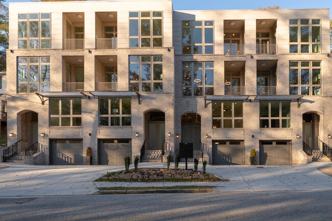
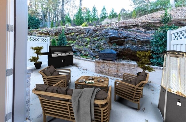
This Property Is For Sale
NEARBY LISTINGS FOR SALE OR LEASE
-
-
View all Roswell listings for sale on LoopNet.com
Property Detail
174 Oxbo Rd
Atlanta-Sandy Springs-Roswell, GA
Fulton
12-2012-0423-058-4
Georgia
Townhouserowhouse
0.07 AC
X
Downtown Roswell
13121C0063G
Atlanta
3,096 SF
DEMOGRAPHICS near 174 Oxbo Rd
1 Mile
3 Mile
5 Mile
2024 Total Population
8,182
67,488
185,394
2029 Population
8,443
68,782
188,098
Pop Growth 2024-2029
+ 3.19%
+ 1.92%
+ 1.46%
Average Age
43
40
40
2024 Total Households
3,573
28,026
73,687
HH Growth 2024-2029
+ 3.36%
+ 2.00%
+ 1.58%
Median Household Inc
$107,916
$97,967
$115,500
Avg Household Size
2.20
2.30
2.50
2024 Avg HH Vehicles
2.00
2.00
2.00
Median Home Value
$438,436
$440,641
$493,072
Median Year Built
1987
1985
1986
Nearby Places
- Restaurants
- Banks
- Shops
- Fitness
- Groceries
PUBLIC TRANSPORTATION
AIRPORT
Hartsfield - Jackson Atlanta International
DRIVE
WALK
Distance
Hartsfield - Jackson Atlanta International
45 min
30.8 mi
Freight Ports
Georgia Ports - Savannah
DRIVE
WALK
Distance
Georgia Ports - Savannah
308 min
270.1 mi
Nearby Properties
Address
Land Use
TOTAL SIZE
Lot Size
Zoning
Address
Land Use
TOTAL SIZE
Lot Size
Zoning
683,219 SF
48.04 AC
R4C
Address
Land Use
TOTAL SIZE
Lot Size
Zoning
1,078,010 SF
3.80 AC
OPC
Address
Land Use
TOTAL SIZE
Lot Size
Zoning
415,701 SF
6.75 AC
OI
Address
Land Use
TOTAL SIZE
Lot Size
Zoning
5,892,558 SF
33.38 AC
R4
Address
Land Use
TOTAL SIZE
Lot Size
Zoning
11.82 AC
Address
Land Use
TOTAL SIZE
Lot Size
Zoning
380,453 SF
10.28 AC
R4
Address
Land Use
TOTAL SIZE
Lot Size
Zoning
1,672,146 SF
21.21 AC
R4
Address
Land Use
TOTAL SIZE
Lot Size
Zoning
7,258,269 SF
38.75 AC
AC
Address
Land Use
TOTAL SIZE
Lot Size
Zoning
7,788,760 SF
46.55 AC
R4
Address
Land Use
TOTAL SIZE
Lot Size
Zoning
792,356 SF
20.07 AC
R5
Address
Land Use
TOTAL SIZE
Lot Size
Zoning
1,909,285 SF
22.39 AC
OI
Address
Land Use
TOTAL SIZE
Lot Size
Zoning
10,614,240 SF
24.05 AC
A
Address
Land Use
TOTAL SIZE
Lot Size
Zoning
2,109,527 SF
70.17 AC
OP
Address
Land Use
TOTAL SIZE
Lot Size
Zoning
8,014,916 SF
28.58 AC
R4
Address
Land Use
TOTAL SIZE
Lot Size
Zoning
10,866,920 SF
31.48 AC
AC
Address
Land Use
TOTAL SIZE
Lot Size
Zoning
510,068 SF
64.18 AC
OPMS
Address
Land Use
TOTAL SIZE
Lot Size
Zoning
938,151 SF
21.22 AC
C3
Address
Land Use
TOTAL SIZE
Lot Size
Zoning
305,733 SF
10.93 AC
OIC
Address
Land Use
TOTAL SIZE
Lot Size
Zoning
1,957,333 SF
19.86 AC
AC
Address
Land Use
TOTAL SIZE
Lot Size
Zoning
5,499,045 SF
22.17 AC
AC
Address
Land Use
TOTAL SIZE
Lot Size
Zoning
1,791,710 SF
27 AC
ACOND
Address
Land Use
TOTAL SIZE
Lot Size
Zoning
1,185,316 SF
19.09 AC
R4
Address
Land Use
TOTAL SIZE
Lot Size
Zoning
1,071,370 SF
22.30 AC
R4
Address
Land Use
TOTAL SIZE
Lot Size
Zoning
1,069,100 SF
0.73 AC
A
Address
Land Use
TOTAL SIZE
Lot Size
Zoning
2,932,336 SF
20.37 AC
AC
Address
Land Use
TOTAL SIZE
Lot Size
Zoning
2,964,850 SF
38.74 AC
R4
Address
Land Use
TOTAL SIZE
Lot Size
Zoning
1,647,821 SF
10.90 AC
OIC
Address
Land Use
TOTAL SIZE
Lot Size
Zoning
3,326,939 SF
23.40 AC
OIC
Address
Land Use
TOTAL SIZE
Lot Size
Zoning
1,198,136 SF
30.94 AC
E2
Address
Land Use
TOTAL SIZE
Lot Size
Zoning
402,680 SF
35.81 AC
The World's #1 Commercial Real Estate Marketplace
Connect with us
© 2025 CoStar Group
The information above has been obtained from sources believed reliable. While we do not doubt its accuracy we have not verified it and make no guarantee, warranty or representation about it. It is your responsibility to independently confirm its accuracy and completeness. Any projections, opinions, assumptions, or estimates used are for example only and do not represent the current or future performance of the property. The value of this transaction to you depends on tax and other factors which should be evaluated by your tax, financial, and legal advisors. You and your advisors should conduct a careful, independent investigation of the property to determine to your satisfaction the suitability of the property for your needs.