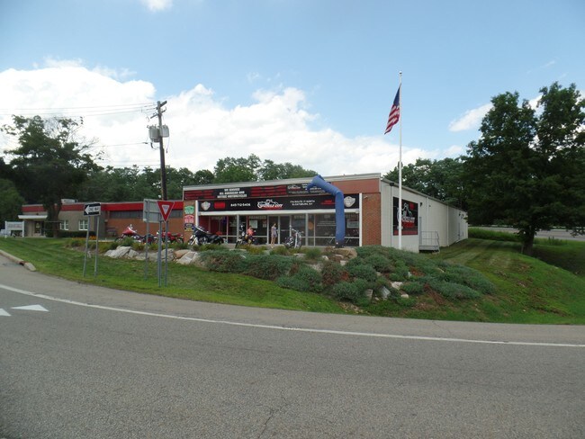
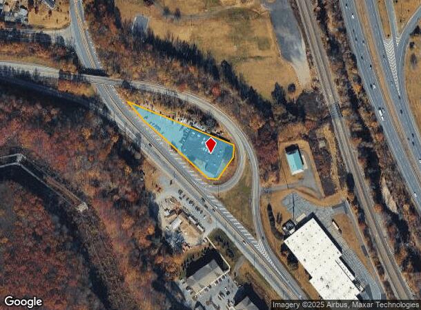
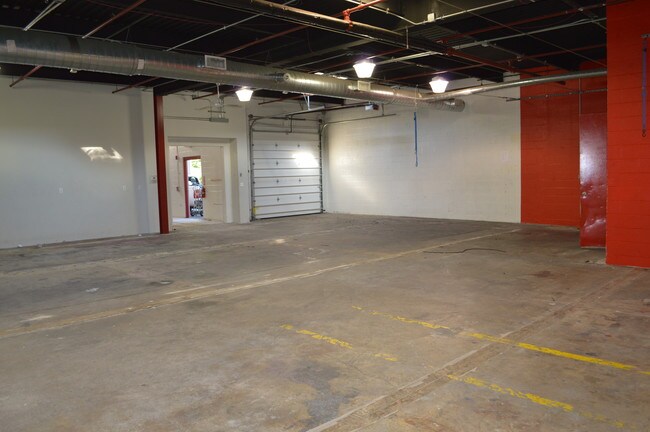
Property Record
174 Route 17, Sloatsburg, NY 10974
NEARBY LISTINGS FOR SALE OR LEASE
Property Detail
174 Route 17
392689-038-016-0001-003-000-0000
Rockland
Warehouse
New York
X
3.0
34003C0014H
1.14 AC
2023
Rockland County
2024
Northern New Jersey
011601
New York-Jersey City-White Plains, NY-NJ
20,210 SF
DEMOGRAPHICS near 174 Route 17
1 Mile
3 Mile
5 Mile
2024 Total Population
2,305
8,555
41,198
2029 Population
2,377
8,709
41,364
Pop Growth 2024-2029
+ 3.12%
+ 1.80%
+ 0.40%
Average Age
41
42
42
2024 Total Households
828
3,191
15,203
HH Growth 2024-2029
+ 3.14%
+ 1.94%
+ 0.41%
Median Household Inc
$108,941
$101,852
$110,799
Avg Household Size
2.80
2.70
2.60
2024 Avg HH Vehicles
2.00
2.00
2.00
Median Home Value
$643,695
$480,057
$447,004
Median Year Built
1968
1968
1969
Nearby Places
- Restaurants
- Banks
- Shops
- Fitness
- Groceries
PUBLIC TRANSPORTATION
COMMUTER RAIL
Sloatsburg (Bergen County/Port Jervis Line - NJ Transit Commuter Rail (NJ Transit), Main/Port Jervis Line - NJ Transit Commuter Rail (NJ Transit))
DRIVE
WALK
Distance
Sloatsburg (Bergen County/Port Jervis Line - NJ Transit Commuter Rail (NJ Transit), Main/Port Jervis Line - NJ Transit Commuter Rail (NJ Transit))
2 min
15 min
0.8 mi
Tuxedo (Bergen County/Port Jervis Line - NJ Transit Commuter Rail (NJ Transit), Main/Port Jervis Line - NJ Transit Commuter Rail (NJ Transit))
DRIVE
WALK
Distance
Tuxedo (Bergen County/Port Jervis Line - NJ Transit Commuter Rail (NJ Transit), Main/Port Jervis Line - NJ Transit Commuter Rail (NJ Transit))
8 min
3.4 mi
AIRPORT
Westchester County
DRIVE
WALK
Distance
Westchester County
47 min
34.1 mi
New York Stewart International
DRIVE
WALK
Distance
New York Stewart International
47 min
35.2 mi
LaGuardia
DRIVE
WALK
Distance
LaGuardia
61 min
41.7 mi
Freight Ports
Maher Terminal
DRIVE
WALK
Distance
Maher Terminal
61 min
41.6 mi
SALE & LEASE HISTORY
LISTING DATE
SALE/LEASE

Mar 26, 2019
For Lease
Feb 27, 2017
For Lease
Nearby Properties
Address
Land Use
TOTAL SIZE
Lot Size
Zoning
Address
Land Use
TOTAL SIZE
Lot Size
Zoning
Address
Land Use
TOTAL SIZE
Lot Size
Zoning
3,716 SF
981.20 AC
Address
Land Use
TOTAL SIZE
Lot Size
Zoning
928 AC
POS
Address
Land Use
TOTAL SIZE
Lot Size
Zoning
460.70 AC
Address
Land Use
TOTAL SIZE
Lot Size
Zoning
4,686 SF
33.17 AC
03
Address
Land Use
TOTAL SIZE
Lot Size
Zoning
7.33 AC
Address
Land Use
TOTAL SIZE
Lot Size
Zoning
200 AC
POS
Address
Land Use
TOTAL SIZE
Lot Size
Zoning
1,545 SF
1.53 AC
05
Address
Land Use
TOTAL SIZE
Lot Size
Zoning
343.02 AC
Address
Land Use
TOTAL SIZE
Lot Size
Zoning
548.90 AC
Address
Land Use
TOTAL SIZE
Lot Size
Zoning
1,389.23 AC
Address
Land Use
TOTAL SIZE
Lot Size
Zoning
237.20 AC
POS
Address
Land Use
TOTAL SIZE
Lot Size
Zoning
131.10 AC
POS
Address
Land Use
TOTAL SIZE
Lot Size
Zoning
22,292 SF
170.28 AC
RR-80
Address
Land Use
TOTAL SIZE
Lot Size
Zoning
123.39 AC
911
Address
Land Use
TOTAL SIZE
Lot Size
Zoning
Address
Land Use
TOTAL SIZE
Lot Size
Zoning
41,237 SF
10.69 AC
Address
Land Use
TOTAL SIZE
Lot Size
Zoning
105.41 AC
POS
Address
Land Use
TOTAL SIZE
Lot Size
Zoning
40.90 AC
911
Address
Land Use
TOTAL SIZE
Lot Size
Zoning
96.47 AC
C200
Address
Land Use
TOTAL SIZE
Lot Size
Zoning
19 AC
911
Address
Land Use
TOTAL SIZE
Lot Size
Zoning
13.30 AC
911
Address
Land Use
TOTAL SIZE
Lot Size
Zoning
12.60 AC
911
Address
Land Use
TOTAL SIZE
Lot Size
Zoning
10 AC
911
Address
Land Use
TOTAL SIZE
Lot Size
Zoning
9.40 AC
911
Address
Land Use
TOTAL SIZE
Lot Size
Zoning
56.17 AC
R-40
Address
Land Use
TOTAL SIZE
Lot Size
Zoning
90,622 SF
9.86 AC
R10
Address
Land Use
TOTAL SIZE
Lot Size
Zoning
107.44 AC
Address
Land Use
TOTAL SIZE
Lot Size
Zoning
72,084 SF
2.07 AC
05
Address
Land Use
TOTAL SIZE
Lot Size
Zoning
26.20 AC
C200
The World's #1 Commercial Real Estate Marketplace
Connect with us
© 2025 CoStar Group
The information above has been obtained from sources believed reliable. While we do not doubt its accuracy we have not verified it and make no guarantee, warranty or representation about it. It is your responsibility to independently confirm its accuracy and completeness. Any projections, opinions, assumptions, or estimates used are for example only and do not represent the current or future performance of the property. The value of this transaction to you depends on tax and other factors which should be evaluated by your tax, financial, and legal advisors. You and your advisors should conduct a careful, independent investigation of the property to determine to your satisfaction the suitability of the property for your needs.