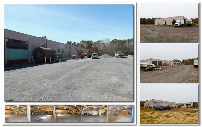
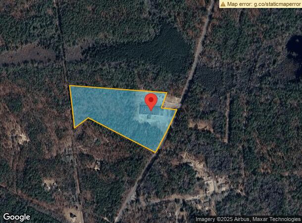
Property Record
176 Route 50, Estell Manor, NJ 08319
Current Lease Availabilities
NEARBY LISTINGS FOR SALE OR LEASE
Property Detail
176 Route 50
Atlantic City-Hammonton, NJ
Estell Manor
09-00043-05-00021
Atlantic
Industrialgeneral
New Jersey
ARE
21
34001C0288F
18 AC
2024
Atlantic City/Hammonton
2025
Philadelphia
011600
DEMOGRAPHICS near 176 Route 50
1 Mile
3 Mile
5 Mile
2024 Total Population
32
3,033
13,772
2029 Population
32
2,983
13,527
Pop Growth 2024-2029
0.00%
(1.65%)
(1.78%)
Average Age
42
47
43
2024 Total Households
12
1,228
5,169
HH Growth 2024-2029
0.00%
(2.28%)
(2.44%)
Median Household Inc
$99,999
$75,434
$77,727
Avg Household Size
2.50
2.40
2.50
2024 Avg HH Vehicles
2.00
2.00
2.00
Median Home Value
$266,666
$223,735
$231,756
Median Year Built
1987
1987
1982
Nearby Places
- Restaurants
- Banks
- Shops
- Fitness
- Groceries
PUBLIC TRANSPORTATION
AIRPORT
Atlantic City International
DRIVE
WALK
Distance
Atlantic City International
42 min
16.1 mi
Freight Ports
Broadway Terminal - Pier 5
DRIVE
WALK
Distance
Broadway Terminal - Pier 5
64 min
47.7 mi
Nearby Properties
Address
Land Use
TOTAL SIZE
Lot Size
Zoning
Address
Land Use
TOTAL SIZE
Lot Size
Zoning
460.68 AC
RA
Address
Land Use
TOTAL SIZE
Lot Size
Zoning
622 SF
142.51 AC
PFMH
Address
Land Use
TOTAL SIZE
Lot Size
Zoning
10,204 SF
4.82 AC
GA-L
Address
Land Use
TOTAL SIZE
Lot Size
Zoning
115.56 AC
RA
Address
Land Use
TOTAL SIZE
Lot Size
Zoning
128.30 AC
RA
Address
Land Use
TOTAL SIZE
Lot Size
Zoning
3,060 SF
2.14 AC
R-25
Address
Land Use
TOTAL SIZE
Lot Size
Zoning
5.37 AC
C
Address
Land Use
TOTAL SIZE
Lot Size
Zoning
1,188 SF
79 AC
R-10
Address
Land Use
TOTAL SIZE
Lot Size
Zoning
1.67 AC
C
Address
Land Use
TOTAL SIZE
Lot Size
Zoning
2,652 SF
30.86 AC
GA-L
Address
Land Use
TOTAL SIZE
Lot Size
Zoning
2.79 AC
R-25
Address
Land Use
TOTAL SIZE
Lot Size
Zoning
5,724 SF
42.24 AC
HC-5
Address
Land Use
TOTAL SIZE
Lot Size
Zoning
Address
Land Use
TOTAL SIZE
Lot Size
Zoning
264.75 AC
RA
Address
Land Use
TOTAL SIZE
Lot Size
Zoning
33.94 AC
HC-5
Address
Land Use
TOTAL SIZE
Lot Size
Zoning
1,540 SF
1.33 AC
RA
Address
Land Use
TOTAL SIZE
Lot Size
Zoning
0.86 AC
PVC
Address
Land Use
TOTAL SIZE
Lot Size
Zoning
2,657 SF
0.64 AC
R-1
Address
Land Use
TOTAL SIZE
Lot Size
Zoning
Address
Land Use
TOTAL SIZE
Lot Size
Zoning
3,626 SF
1.05 AC
GA-L
Address
Land Use
TOTAL SIZE
Lot Size
Zoning
378 AC
R-25
Address
Land Use
TOTAL SIZE
Lot Size
Zoning
2,516 SF
0.50 AC
GA-L
Address
Land Use
TOTAL SIZE
Lot Size
Zoning
Address
Land Use
TOTAL SIZE
Lot Size
Zoning
3,332 SF
20.65 AC
R-25
Address
Land Use
TOTAL SIZE
Lot Size
Zoning
3,049 SF
1.25 AC
GA-L
Address
Land Use
TOTAL SIZE
Lot Size
Zoning
0.52 AC
RA
Address
Land Use
TOTAL SIZE
Lot Size
Zoning
15,849 SF
6.20 AC
GA-L
Address
Land Use
TOTAL SIZE
Lot Size
Zoning
0.78 AC
R-2
Address
Land Use
TOTAL SIZE
Lot Size
Zoning
The World's #1 Commercial Real Estate Marketplace
Connect with us
© 2025 CoStar Group
The information above has been obtained from sources believed reliable. While we do not doubt its accuracy we have not verified it and make no guarantee, warranty or representation about it. It is your responsibility to independently confirm its accuracy and completeness. Any projections, opinions, assumptions, or estimates used are for example only and do not represent the current or future performance of the property. The value of this transaction to you depends on tax and other factors which should be evaluated by your tax, financial, and legal advisors. You and your advisors should conduct a careful, independent investigation of the property to determine to your satisfaction the suitability of the property for your needs.