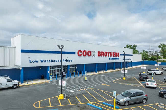
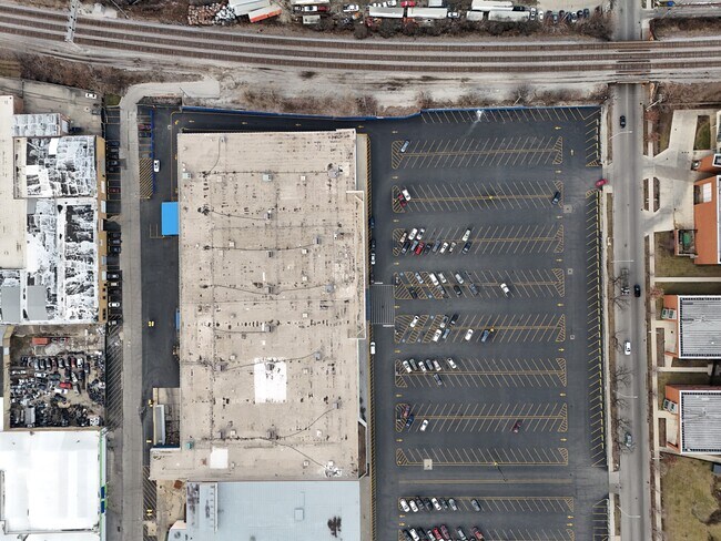
Property Record
1740 N Kostner Ave, Chicago, IL 60639

NEARBY LISTINGS FOR SALE OR LEASE
Property Detail
1740 N Kostner Ave
13-34-311-004-0000
Hamiltons
Commercialbuilding
Cook
X
Illinois
17031C0415J
6.54 AC
2023
Northwest City
2025
Chicago
230500
Chicago-Naperville-Elgin, IL-IN-WI
109,176 SF
DEMOGRAPHICS near 1740 N Kostner Ave
1 Mile
3 Mile
5 Mile
2024 Total Population
41,872
390,682
1,056,786
2029 Population
38,131
363,892
998,977
Pop Growth 2024-2029
(8.93%)
(6.86%)
(5.47%)
Average Age
37
37
37
2024 Total Households
13,310
145,906
416,431
HH Growth 2024-2029
(9.42%)
(7.11%)
(5.55%)
Median Household Inc
$51,312
$63,340
$78,364
Avg Household Size
3.00
2.60
2.40
2024 Avg HH Vehicles
1.00
1.00
1.00
Median Home Value
$265,923
$339,740
$373,968
Median Year Built
1946
1947
1948
Nearby Places
Map Layers
Map Styles
 Street
 Aerial
- Restaurants
- Banks
- Shops
- Fitness
- Groceries
PUBLIC TRANSPORTATION
COMMUTER RAIL
Grand/Cicero Station (Milwaukee District West Line - Northeast Illinois Regional Commuter Railroad (Metra), North Central Service - Northeast Illinois Regional Commuter Railroad (Metra))
DRIVE
WALK
Distance
Grand/Cicero Station (Milwaukee District West Line - Northeast Illinois Regional Commuter Railroad (Metra), North Central Service - Northeast Illinois Regional Commuter Railroad (Metra))
3 min
15 min
0.8 mi
Healy Station (Milwaukee District North Line - Northeast Illinois Regional Commuter Railroad (Metra))
DRIVE
WALK
Distance
Healy Station (Milwaukee District North Line - Northeast Illinois Regional Commuter Railroad (Metra))
3 min
1.3 mi
AIRPORT
Chicago Midway International
DRIVE
WALK
Distance
Chicago Midway International
19 min
10.2 mi
Chicago O'Hare International
DRIVE
WALK
Distance
Chicago O'Hare International
23 min
13.6 mi
Freight Ports
Port Milwaukee
DRIVE
WALK
Distance
Port Milwaukee
101 min
81.9 mi
SALE & LEASE HISTORY
LISTING DATE
SALE/LEASE

Jun 27, 2024
For Sale
Nearby Properties
Address
Land Use
TOTAL SIZE
Lot Size
Zoning
Address
Land Use
TOTAL SIZE
Lot Size
Zoning
73,700 SF
0.48 AC
RM-6.5
Address
Land Use
TOTAL SIZE
Lot Size
Zoning
192,365 SF
21.34 AC
PD 127
Address
Land Use
TOTAL SIZE
Lot Size
Zoning
0.66 AC
RS-3
Address
Land Use
TOTAL SIZE
Lot Size
Zoning
277,195 SF
1.78 AC
PD 1094
Address
Land Use
TOTAL SIZE
Lot Size
Zoning
110,806 SF
0.86 AC
POS-1,PD 9
Address
Land Use
TOTAL SIZE
Lot Size
Zoning
237,832 SF
14.04 AC
PD 418
Address
Land Use
TOTAL SIZE
Lot Size
Zoning
190,011 SF
5.90 AC
PD 353
Address
Land Use
TOTAL SIZE
Lot Size
Zoning
1.04 AC
PD 130
Address
Land Use
TOTAL SIZE
Lot Size
Zoning
6.31 AC
PD 1013
Address
Land Use
TOTAL SIZE
Lot Size
Zoning
55,559 SF
0.63 AC
RT-4
Address
Land Use
TOTAL SIZE
Lot Size
Zoning
32,500 SF
0.56 AC
RT-4
Address
Land Use
TOTAL SIZE
Lot Size
Zoning
382,635 SF
5.90 AC
M1-1
Address
Land Use
TOTAL SIZE
Lot Size
Zoning
15,600 SF
0.77 AC
M1-1
Address
Land Use
TOTAL SIZE
Lot Size
Zoning
3.33 AC
PD 1013
Address
Land Use
TOTAL SIZE
Lot Size
Zoning
340,838 SF
31 AC
PD 1411
Address
Land Use
TOTAL SIZE
Lot Size
Zoning
0.57 AC
PD 536
Address
Land Use
TOTAL SIZE
Lot Size
Zoning
194,582 SF
12.68 AC
PD 699
Address
Land Use
TOTAL SIZE
Lot Size
Zoning
0.58 AC
B3-2
Address
Land Use
TOTAL SIZE
Lot Size
Zoning
13.33 AC
PD 127
Address
Land Use
TOTAL SIZE
Lot Size
Zoning
10,400 SF
0.20 AC
B3-5
Address
Land Use
TOTAL SIZE
Lot Size
Zoning
226,155 SF
5.86 AC
PMD 9
Address
Land Use
TOTAL SIZE
Lot Size
Zoning
Address
Land Use
TOTAL SIZE
Lot Size
Zoning
78,410 SF
4.87 AC
PD 171
Address
Land Use
TOTAL SIZE
Lot Size
Zoning
0.66 AC
PD 852
Address
Land Use
TOTAL SIZE
Lot Size
Zoning
93,409 SF
2.05 AC
PD 146
Address
Land Use
TOTAL SIZE
Lot Size
Zoning
0.43 AC
RS-2
Address
Land Use
TOTAL SIZE
Lot Size
Zoning
123,185 SF
7.98 AC
PD 752
Address
Land Use
TOTAL SIZE
Lot Size
Zoning
389,400 SF
28.83 AC
PMD 9
Address
Land Use
TOTAL SIZE
Lot Size
Zoning
417,300 SF
2.84 AC
PD 621
Address
Land Use
TOTAL SIZE
Lot Size
Zoning
277,819 SF
10.58 AC
PD 127
The World's #1 Commercial Real Estate Marketplace
Connect with us
© 2026 CoStar Group
The information above has been obtained from sources believed reliable. While we do not doubt its accuracy we have not verified it and make no guarantee, warranty or representation about it. It is your responsibility to independently confirm its accuracy and completeness. Any projections, opinions, assumptions, or estimates used are for example only and do not represent the current or future performance of the property. The value of this transaction to you depends on tax and other factors which should be evaluated by your tax, financial, and legal advisors. You and your advisors should conduct a careful, independent investigation of the property to determine to your satisfaction the suitability of the property for your needs.